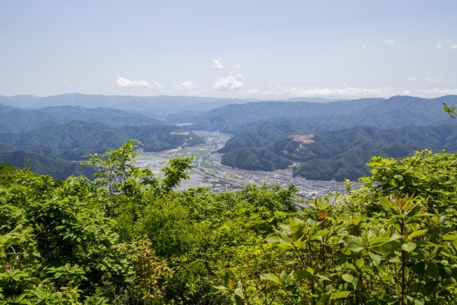
Mount Hino (日野山, Hinosan), laughably nicknamed “Mt. Fuji of Echizen”, is a day hike located in Echizen City, Fukui (福井県越前市).
The summit is 2,608 ft / 795 m above sea level which makes this more of a hill than a mountain, but the trek up Mount Hino will still get your blood pumping, and the summit offers decent views(?) as well.
A train station is located near the trailhead so Mount Hino can be reached even without your own transportation.
Mount Hino Facts
- Name: Mount Hino
- Japanese name: 日野山 (Hinosan)
- Location: Echizen City, Fukui, Japan (福井県越前市)
- Summit elevation: 2,608 ft / 795 m
- Elevation change: 2,346 ft / 715 m
- Round-trip distance from trailhead: 3.85 mi / 6.2 km
- Round-trip time from trailhead*: 3 hours
- Difficulty: Easy-Moderate
- Water on the trail: No
- Trailhead facilities: Parking
- Nihon Hyaku-meizan: No
*NOTE: The round-trip time listed above is based on my own experience. Please remember that your time may vary greatly.
Getting to Mount Hino
- Region: Chubu (中部地方)
- Accessible via public transportation: Yes
- Trailhead parking: Yes
- Trailhead coordinates: 35.864457, 136.188455
- Summit coordinates: 35.859686, 136.207146
BY CAR: Access to Mount Hino with a car is simple. You can find parking in a lot just down the road from the shrine where the trail begins. The coordinates for the parking lot are 35.864215, 136.183312. Its location (and the location of the trailhead) has been marked on the map below.
BY TRAIN: The nearest train station to Mount Hino is Oshio Station located on the JR Hokuriku Main Line. From the station, the trailhead is a 1.4 mi / 2.2 km walk to the east. Always double-check the train schedules on Hyperdia before committing to anything.
BY BUS: There is not any bus access to the trailhead that I could find. If you know otherwise, please let me know and I will update this information.
The Hike
The trek up Mount Hino begins by passing through (or just north of) Hino Shrine (don’t worry, you’re going the right way).
At the back of the shrine, you’ll find a chain link fence with a bunch of signage and a gate marking the beginning of the trail (don’t let the signs about bears scare you).
Mount Hino has both an “old” and a “new” trail. The new trail has a more gentle slope and slowly switchbacks its way up the mountain. The old trail climbs steeply, cutting through the newer trail many times on its way to the summit.
You can opt to take either, but don’t worry about choosing the “wrong one”. You will have more than a couple of times to change your mind on the way up the mountain (if you’re wondering how to tell, the old trail is the one that looks steeper and more difficult – you’ll know).
The old trail can be pretty steep at times, and it stays mostly hidden in the trees. Should you opt for the new trail you will be greeted by a much wider path and some views of the surrounding area.
No matter which trail you decide to take it’s climbing the entire way.
You’ll pass a few ladders and metal staircases affixed in the trail as you make your way up. About halfway to the top, there are two shelters to hang out at if you’re feeling tired. If not, save your break for the summit – it really isn’t that much farther.
The Summit
The summit of Mount Hino is home to a newly constructed shelter that could easily fit a dozen or more people (party time?).
A short walk (or staircase climb) up behind the shelter and you’ll find a small shrine and the summit marker. From here, if the weather cooperates, you can get some good views of Mount Haku and the surrounding mountains (kanji labeled map provided).
Just before the summit marker is a small spur trail to the right that will take you about a minute to walk down. Here you can find another summit marker – this one featuring the altitude as well (because Hino-san is a monster of a mountain).
When you’re finished, you can head back down the way you came, or you can head down an alternate trail on Mount Hino’s north side (it’s to your left when you first approach the summit).
The alternate will bring you back to the same place, but you’ll have to make a left (there are two opportunities to do this) later down the mountain to get back to the trailhead.
Conclusion
If you somehow find yourself in Fukui, and more specifically, Echizen City, then Mount Hino may be worth your time.
Otherwise, chances are that there are plenty of other hikes closer to you to tackle.
Have any questions about Mount Hino? Want another post about another one of Japan’s mountains? Have a suggestion to improve this information?
Leave a comment and let me know!


