Check out the most recent PCT Survey results here.
To provide more useful information to those looking to hike the Pacific Crest Trail, I surveyed over 100 people who attempted a thru-hike in 2013.
Demographics
So, who is the stereotypical Pacific Crest Trail hiker? According to the survey data, it is an unmarried 26-year-old white male from California with a bachelor’s degree (who smells like garbage).


- Sex: 65% Male, 35% Female
- Age: 26 Average (0% under 18, 28% 18-24, 52% 25-34, 16% 35-54, 4% 55+)
- Race: 88% White, 2% Asian, 2% Hispanic, 5% Multi-Racial, 3% No Response
- Education: 50% Bachelor’s Degree, 23% Some College, 15% Graduate Degree, 8% Associate Degree, 6% High School Diploma
- Country: USA, UK, Canada, Australia, Finland, France, Germany, Israel, Italy, Japan, Sweden
- States: Alabama, Alaska, Arizona, California, Colorado, Connecticut, Georgia, Idaho, Illinois, Maryland, Massachusetts, Michigan, Minnesota, Missouri, New York, North Carolina, Ohio, Oregon, South Carolina, Texas, Vermont, Virginia, Washington
Starting
The story here? Our average hiker was NOBO on his first long-distance hike. He began alone on April 20. He may or may not have gone to ADZPCTKO and got all his permits beforehand.


- Direction Hiked: 99% Northbound, 1% Southbound
- First Long Hike: 71% Yes, 29% No
- Began Alone: 60% Yes, 40% No
- Permits Obtained: 100% Hiking Permit, 70% Entry To Canada Permit, 77% CA Fire Permit
- Kickoff Attendance: 50% Did Not Attend, 6% Would Not Attend Again, 44% Would Attend Again
- Happy With Start Date: 85% Yes, 15% No
- Month Started: 3% March, 72% April, 21% May, 4% June
- Most Popular Start Date: April 20
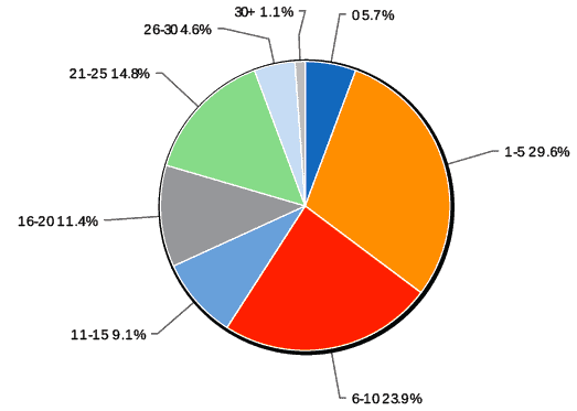
- Start Date: Before April 8 7%, April 8 – April 14 13%, April 15 – April 22 25%, April 23 – April 30 20%, May 1 – May 7 8%, May 8 – May 14 4%, May 15 – May 22 6%, After May 22 6%
Hiking
Now that we know when our hiker started, what were his statistics while hiking the trail? Well, his longest day was 35.3 miles, he took 20 zeroes, and 16 near-os, made it 2,168 miles through the trail sometime in September (did not finish due to weather), and he would most certainly hike the PCT again. He also thought he was adequately prepared before the hike, and in retrospect, he may have been a tad over-prepared.


- Longest Day: Average 35.3 (σ = 8)
- Zeroes: Average 20 (σ = 11)
- Near-os: Average 16 (σ = 10)
- Miles Hiked: Average 2,168 (σ = 700)
- Finished: 48% Yes, 52% No
- Reason For Not Finishing: 40% Weather, 18% Injury, 10% Mental/Emotional, 32% Other
- Would Hike PCT Again: 92% Yes, 8% No
The data also showed that although most hikers felt adequately prepared both pre-hike and retrospectively, the number of hikers who felt over-prepared increased by 15% post-hike hike (cutting into those who felt adequately prepared).
Resupply
Moving on to the all-important topic of resupply, our hiker made 22 resupply stops. He didn’t mail himself nine resupply boxes and did not use a bounce box or rely on hiker boxes.


- Resupply Stops Made: 22 Average (σ = 9)
- Resupply Strategy: 75% Mailed some boxes, 19% All, 6% Mailed no boxes
- Resupply Boxes Sent: 9 Average (σ = 8)
- Bounce Box: 31% Yes, 69% No
- Hiker Box Reliance: 32% Yes, 68% No
Three more questions were asked of the respondents: where would you definitely send a resupply box in the future, where would you have opted to send yourself a resupply box instead of buying food, and if there was anything about their resupply strategy they would have changed?
Definitely mail a box:
- Kennedy Meadows, CA (Overwhelmingly)
- Stehekin, WA (Overwhelmingly)
- Skykomish/The Dinsmores, WA
- Crater Lake (Mazama), OR
- White Pass, WA
- Snoqualmie Pass, WA
- Warner Springs, CA
- Shelter Cove
- Timberline Lodge, OR
- Belden, CA
Mail a box instead of buying:
- Sierra City, CA
- Seiad Valley, CA
- Vermilion Valley Ranch, CA
Changes to your strategy?
- Send fewer boxes (Overwhelmingly)
- Send less food
- Send a larger variety of food
- Only send boxes from on-trail
Lastly, I asked hikers to list everywhere they resupplied over the course of the trail. In geographical order, starting with Mexico, here are the most popular resupply stops(*)(**):
- Mount Laguna, CA (84%)
- Warner Springs, CA (87%)
- Paradise Cafe, CA (81%)
- Idyllwild, CA (78%)
- Wrightwood, CA (82%)
- The Saufley’s, CA (87%)
- Hikertown, CA (73%)
- Tehachapi, CA (65%)
- Kennedy Meadows, CA (91%)
- Mammoth Lakes, CA (72%)
- Tuolumne Meadows, CA (82%)
- South Lake Tahoe, CA (71%)
- Sierra City, CA (79%)
- Old Station, CA (62%)
- Burney Falls, CA (62%)
- Seiad Valley, CA (75%)
- Ashland, OR (60%)
- Mazama Village Store (Crater Lake), OR (68%)
- Shelter Cove Resort, OR (67%)
- Timberline Lodge, OR (74%)
- Cascade Locks, OR (77%)
- White Pass, WA (72%)
- Snoqualmie Pass, WA (69%)
- Skykomish/The Dinsmores (52%)
- Stehekin, WA (52%)
*The percentages for Washington resupply stops would have been much higher had everyone who participated in the survey finished the entire trail.
**This does not translate (at all) into a resupply strategy because there are many resupply stops where hikers are split between two locations.
Gear
Back to our hiker-man, and this time, we are looking at his gear. He started the trail (April 20) with a base weight of 22.6 pounds, but when he finished, he was down to 18.4 (a 4.2-pound saving). He always made sure to filter his water, carried paper maps, did not rely on his cell phone, and spent a whopping $1,245 on gear before the hike. Oh, and he kept a journal.
- Starting Base Weight: 22.6 lb Average (σ = 12.2)
- Ending Base Weight: 18.4 lb Average (σ = 8.6)
- Filter Water: 42% Yes, 14% No, 34% Sometimes, 10% Only In Desert
- Average Spent On Gear: $1,245 (σ = $696)
- Paper Maps: 75% Yes 25% No
- Cell Phone Reliance: 45% Yes 55% No
- Journal: 61% Yes, 39% No
What gear took you the longest to drop from your pack?
- Extra Clothing
- Water Filter
- Sleeping Pad
- Camp Shoes
- First Aid Kit
What gear do you wish you had replaced/invested more in?
- Tent (lighter)
- Sleeping Bag (warmer/down)
- Backpack (more comfortable)
- Rain Jacket
- Water Filter
Top comments on gear for future hikers:
- Go lighter.
- More expensive doesn’t mean better.
- Get a good down sleeping bag.
- Good gear is worth the investment.
- You will get sick of your Sawyer Squeeze.
Miscellaneous
The average number of bears seen on the trail was three, and a total of twelve Pacific Crest Trail thru-hikers saw no bears.
What was the FAVORITE section of the trail? Here are the top five responses:
- The Sierra (Overwhelmingly)
- Goat Rocks
- North Cascades
- Washington
- The Entire Trail
What was the LEAST FAVORITE section of the trail? Here are the top five responses:
- CA Section F -The Mojave (Overwhelmingly)
- The Desert
- Northern California
- Burn Areas (there are a lot)
- Fuller Ridge
What resource did you find MOST VALUABLE when planning your hike?
- Past Thru-Hikers
- Halfmile’s Maps
- Blogs
- Yogi’s Guide
- Craig’s PCT Planner
What resource did you find LEAST VALUABLE when planning your hike?
- Yogi’s Guide
- Guidebooks
- PCT-L
- Other people’s opinions
- PCT Data Book
Advice hikers have for future Pacific Crest Trail thru-hikers.
The gist of it:
- Just do it!
- HYOH (hike your own hike)
- Don’t over-think or over-plan it
- Don’t stress; it all will work out – the trail provides
- Have fun; slow down and enjoy the little things
- Take pictures of everything (especially people)
The message here is clear: relax, people. Don’t worry too much about planning or what will happen once you get on the trail (because all your plans will fall apart).
More comprehensive responses:
“The PCT is a mental challenge – if you understand that it’s going to be really difficult (in ways you don’t even realize yet) but you have the determination to keep going, it is a completely attainable goal to reach Canada, even for the least experienced. That being said, never quit on a bad day. Inevitably, something wonderful will happen the next day that makes you realize why you’re out there in the first place. Hang in there. It’s worth it.”
“Accept that it will be tough before you start. Once you accept it, the trail doesn’t seem as tough after all. Don’t worry about planning too much for the hike. You’ll figure it out along the way. You’ll have plenty of time to think about your next move. Unexpected things will happen, some good and some bad. Expect the unexpected might happen and roll with it. You’ll never be the same.”
“Love the trail, and the trail will love you back. The worst day on the PCT is better than the best day at work.”
“Do what feels right to you at the moment. Try not to hold too strongly to ideas or plans you had before you started; let the trail shape you. The trip takes on a life of its own once you’re out there, and that’s the best part!”
“GO. Be open to letting things happen and know you’ll be fine adapting to what will come at you. It’s simultaneously easier and harder than you think. People obsessively plan because they are afraid of not having control. Most of your control disappears in the first several days.”
“It will all come together in the end. Just get on the trail, and you will figure it out as you go (and get really good at it).”
“Take the hike one resupply at a time, don’t think ahead too much; it’s all mental, have a sense of humor, and don’t take yourself too seriously.”
What do you wish you had done differently before starting your hike (or during your hike)?
- Had an earlier start date
- Started with less (or lighter) stuff
- Had a larger variety of food
- Physically trained more
- Slowed down, stressed less
AND THAT’S IT! If you have any questions about the data or would like more information, then please leave a comment below.