
Guide to Hiking the Mount Anne Circuit in Tasmania
The Mount Anne Circuit is named for the 4,669 ft / 1,423 m Mount Anne – the highest peak in Tasmania’s Southwest National Park. I would expect the Mount Anne Circuit to circumnavigate Mount Anne (hence the circuit bit), but this track does no such thing. A more appropriate name may be the “Mount Anne Adjacent Circuit.” The circuit actually passes just south of Mount Anne, but you are definitely encouraged to detour to the summit (this is what most people come here to do – the entire circuit is much less popular than an out-and-back to the summit of Mount Anne).
You’re likely to see other hikers between Condominium Creek Car Park, Mount Anne, and Shelf Camp (one of the campsites along the circuit), but heading clockwise from Shelf Camp, you’ll probably find yourself mostly alone. If these names mean nothing to you, that’s okay; keep reading.

Mount Anne Circuit Basics
- Location: Southwest National Park, Tasmania
- Length: 20.94 mi / 33.7 km
- Type: Loop
- Officially Recommended Time: 4 to 5 days
- My Suggested Time: 2 days
- Possible Time: 1 day
- Booking Required: Yes (link)
- Booking Cost: A$0
- Permit Required: Tasmania Parks Pass (buy)
- Permit Cost: A$12-$60
- Mount Anne Summit Location: -43.271576, 146.474932
- Trailhead Location: Condominium Creek Car Park on Scotts Peak Road: -42.958253, 146.361967
- Alternate trailhead Location: Red Tape Creek on Scotts Peak Road: -43.019508, 146.365839
- Elevation Gain*: 6,562 ft / 2,000 m
- High Point: Mount Anne – 4,669 ft / 1,423 m
- Difficulty: Strenuous
*These numbers are approximates.


Registration
Hikers are required to register before departing the Mount Anne Trailhead.
You can register for the Mount Anne Circuit and Mount Anne here.
There are a maximum of twelve people permitted to depart each day, and you’re limited to spending a maximum of five nights on the circuit and a maximum of three nights at Shelf Camp and Lonely Tarn.
How to Get to the Mount Anne Circuit
The only way to reach the Mount Anne Circuit is by car. You can get part of the way via bus, but from there, you’ll be driving, hitchhiking, or walking a long way to make it to the trailhead. The trailhead is 12.3 mi / 19.8 km down the unpaved Scotts Peak Road from the (paved) Gordon River Road.
- Accessible via public transportation: No
- Trailhead parking: Yes (free, unmetered)
- Trailhead coordinates: -42.958253, 146.361967
BY CAR: The start of the Mount Anne Circuit (assuming you’re starting at the side closer to Mount Anne and hiking clockwise) is 12.3 mi / 19.8 km south on the unpaved (or, as they say in Australia, unsealed) Scotts Peak Road from Gordon River Road (B61). From Hobart, it’s an 83.26 mi / 134 km drive that takes upwards of three hours. It’s quite remote. There’s plenty of free, unmetered parking at the trailhead.
BY TRAIN: Sorry, no trains.
BY BUS: The closest you can get to the trailhead via bus is the town of Westerway ($13.30 AU from Hobart). From here, it’s another 31 mi / 50 km down Gordon River Road before the turnoff on Scotts Peak Road.
BY PRIVATE TRANSPORT: Several companies in Hobart and around Tasmania offer transport to/from trailheads. From what I can see, a one-way ride from Hobart to the start of the Mount Anne Circuit will probably cost you around $160 AU.
HITCHHIKING: Hitchhiking to the start of the Mount Anne Circuit is possible, but it probably won’t be easy. Several other hikes down Scotts Peak Road (the unpaved road that takes you to the trailhead) include the Port Davey Track, the Creepy Crawly Trail, and the Western Arthurs Traverse. However, I would suggest giving yourself extra time and bringing some extra food if you go this route. That said, I picked up a hitchhiker and brought him all the way here shortly after he started hitchhiking, so you might get lucky.


Notes on the Mount Anne Circuit
The following are some notes to help you more easily understand exactly what I’m saying in this post since when I was doing my research, I found things to be a little confusing.
- There are no fires permitted anywhere along the Mount Anne Circuit.
- Tasmania is notorious for its unpredictable and quickly changing weather. Make good decisions.
- There is one unstaffed and unmaintained hut on the circuit – High Camp Memorial Hut. It’s located on the way up to Mount Eliza (before reaching Mount Anne) and has room for five or six people to sleep comfortably.
- The fungus phytophthora cinnamomi is rampant in Tasmania and kills native plants. Clean your shoes, gaiters, and trowel beforehand (there’s a shoe-cleaning station at the start of the track).
- You may read reports of people bringing a rope for climbing and pack hauling on this track (particularly for a spot referred to as “The Notch”). This is not required; I climbed it just fine without a rope. However, bringing a rope may be a good idea if you’re uncomfortable doing anything that requires using your hands, with moderate exposure, or hiking in adverse weather conditions.
- Although this hike is a loop, the western side of the loop is along Scotts Peak Road (the unpaved road you’ll come in on). This section is ~5.1 mi / 8.2 km long – you’ll only find (official) parking at the northern junction with the road (where most people begin the Mount Anne Circuit).
- There are two named campsites on the Mount Anne Circuit are Shelf Camp and Lonely Tarns Camp.
- If you’re confused, “car park” means “parking lot.”


Mount Anne Circuit Itinerary
The suggested Mount Anne Circuit Traverse itinerary calls for three to five days. Five days is a bit absurd, and I think the longest that you could reasonably expect to take (if you really were taking your time is four days. The entire circuit is only 20.94 mi / 33.7 km. That said, I’ve included a five-day itinerary below. I completed the track in two days and spent the night at Shelf Camp. A one-day trip would be possible if you really wanted to go for it. Two or three days will probably be comfortable for most people.
Here are some example itineraries:
- Day 1: 2.24 mi / 3.6 km – Condominium Creek Car Park to High Camp/Memorial Hut
- Day 2: 1.93 mi / 3.1 km – High Camp/Memorial Hut to Shelf Camp via Mount Anne
- Day 3: 2.42 mi / 3.9 km – Shelf Camp to Lonely Tarns Camp
- Day 4: 4.66 mi / 7.5 km – Lonely Tarns Camp to Lake Judd via Lake Judd Track
- Day 5*: 9.51 mi / 15.3 km – Lake Judd to Condominium Creek Car Park
- Day 1: 2.24 mi / 3.6 km – Condominium Creek Car Park to High Camp/Memorial Hut
- Day 2: 1.93 mi / 3.1 km – High Camp/Memorial Hut to Shelf Camp via Mount Anne
- Day 3: 2.42 mi / 3.9 km – Shelf Camp to Lonely Tarns Camp
- Day 4*: 12.49 mi / 20.1 km – Lonely Tarns Camp to Condominium Creek Car Park
- Day 1: 6.03 mi / 9.7 km – Condominium Creek Car Park to Shelf Camp via Mount Anne
- Day 2: 2.42 mi / 3.9 km – Shelf Camp to Lonely Tarns Camp
- Day 3*: 12.49 mi / 20.1 km – Lonely Tarns Camp to Condominium Creek Car Park
Here’s what I did:
- Day 1: 4.17 mi / 6.71 km – Condominium Creek Car Park to Shelf Camp via Mount Anne
- Day 2*: 16.77 mi / 26.99 km – Shelf Camp to Condominium Creek Car Park
*You can shorten the final day by ~5.1 mi / 8.2 km if transport awaits you at Red Tape Creek Trailhead/Lake Judd Track trailhead, where the circuit intersects with Scotts Peak Road in the south.


Mount Anne Circuit Track
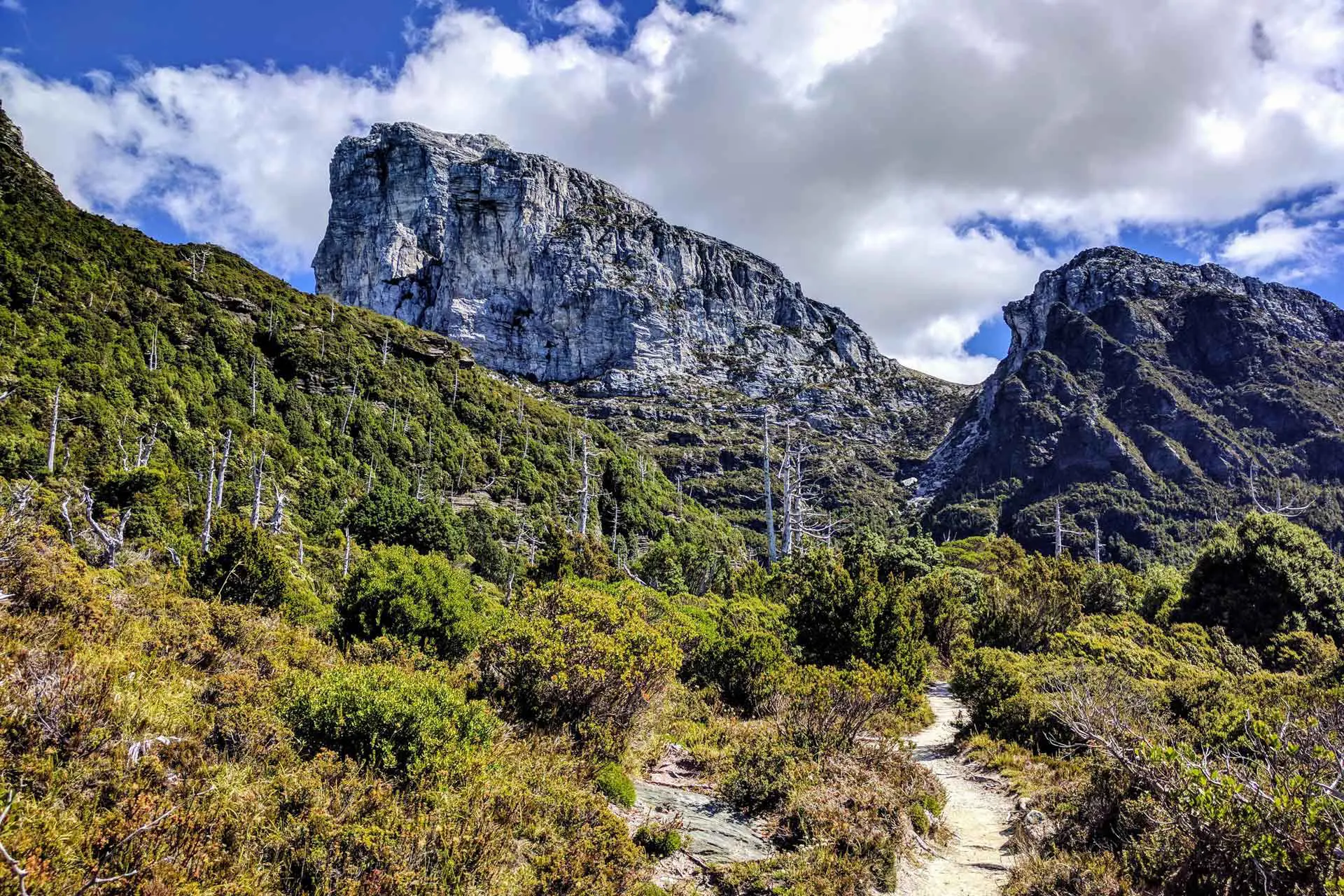
You can start this trail at either the Condominium Creek Car Park (the trailhead for Mount Anne and Mount Eliza), 12.3 mi / 19.8 km south of Gordon River Road, or the Red Tape Creek Trailhead (also the Lake Judd Trailhead), another 5.1 mi / 8.2 south on Scotts Peak Road from Condominium Creek. The loop can be hiked in either direction, but most people start at the Mount Anne/Mount Eliza trailhead and hike clockwise. This is what I did and is the route I will describe here.
The trail is easy to follow from the parking lot and begins with a short flat section before climbing up the ridge. This climb is 3,080 ft / 939 m, and there aren’t many good spots to stop and rest before you reach High Camp Memorial Hut after 2,625 ft / 800 m of elevation gain. The hut was in okay shape when I was there – a little dirty but habitable. It has an upstairs loft and room for five or six people to sleep comfortably. I wouldn’t recommend sleeping here unless the weather is garbage.
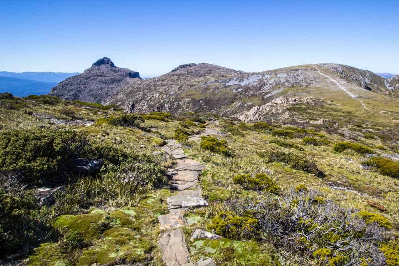
From High Camp Memorial Hut, it’s another 785 ft / 239 m of mostly scrambling up a steep boulder field to the summit of Mount Eliza. The trail isn’t always clear here, but as long as you head up, you’re going the right way. If the weather is clear at the summit of Mount Eliza (4,229 ft / 1,289 m), you’ll have great views of Lake Pedder, Edgar Bay, and even the Western Arthurs to the south if you’re lucky.


From Mount Eliza, the track levels out a bit as it heads north to a small saddle where you’ll find a couple of tarns (I don’t know if these always have water, but there was plenty when I was there). You’ll also have good views of Mount Anne directly ahead of you.
After a small incline, as you skirt around the western side of Eve Peak, the trail comes to a junction – straight for Mount Anne, right for Shelf Camp. If it’s late in the day, if the weather is bad, or if you want to extend your trip, you can spend the night at Shelf Camp and attempt Mount Anne the following day. However, if you have the time, weather, and energy, Mount Anne is easily doable on your first day.
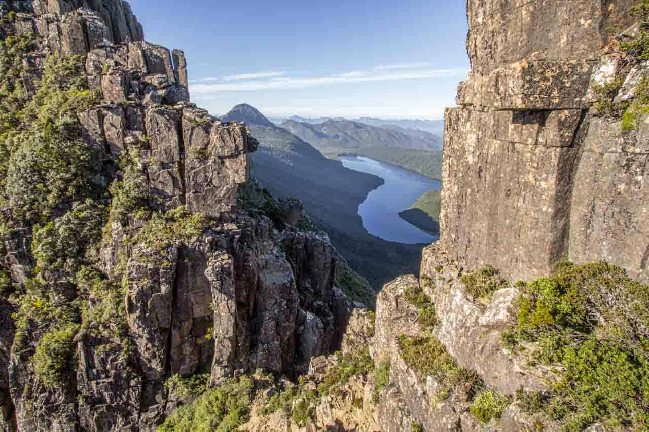
Continuing to Mount Anne, you keep to the ridge as the trail passes through another boulder field and past a high point before descending slightly and approaching Mount Anne. The route up Mount Anne climbs up and then hooks around to the right. It’s a bit of a scramble, and you’ll need to use your hands to get up and back down. It is a little exposed, and falling at certain points could be a mistake, but it’s nothing crazy. At the summit, you’ll find a logbook and great views of the hiking to come on the rest of the circuit, looking toward Mount Lot to the southeast.


Returning to the Shelf Camp junction, it’s a short hike down to the campsite. There are a few tarns here and plenty of flat, rocky spots for camping. You might have trouble pitching a tent here if you don’t have a freestanding shelter. There are great views of Mount Anne, and I would definitely recommend camping here – it’s a beautiful spot. If Shelf Camp is crowded, a few more suitable campsites are a bit further east or just north down the mountain.
Heading clockwise from Shelf Camp, the trail skirts around the northern side of the mountains with a bit of scrambling. The trail isn’t always obvious here, and I ended up doing a weird downclimb at one point, but if you stick close to the mountain, you’ll find your way eventually. After a short climb and downclimb, you’ll reach The Notch. This is a feature that some people like to make a big deal about, but it’s really just a short scramble down and then back up some semi-exposed rock (this is where you might read about people bringing a rope). If you were comfortable climbing up and down Mount Anne, you should be comfortable here. That said, bring a rope (and knowledge of how to use it) if you’re unsure of yourself.
If not for me having previously read about The Notch, I would have found it fairly unremarkable (as far as the difficulty – the views of Lake Judd from here are great). After The Notch, you continue climbing Mount Lot’s summit (4,140 ft / 1,262 m) before heading down a steep, somewhat overgrown trail along Lightning Ridge.


Just as the ridge flattens, the trail dives into the brush and descends east toward Lake Picone and Lonely Tarns Camp. This section is overgrown, but once you reach the tarns, the brush gives way to flat and easy walking.
Lonely Tarns Camp is on the eastern side of the largest tarn. If you’re taking time with the circuit, this is a good place to camp. The trail heads south and west from here, completing a horseshoe around the large tarn before continuing south up a small climb.
If you’re feeling adventurous, it looks like you might be able to stay high and follow Lightning Ridge all the way to Mount Sarah Jane before meeting back up with the track, but I have no idea if this is doable, and it will probably require some exposed scrambling. I will probably try it if I make it back to the Circuit.


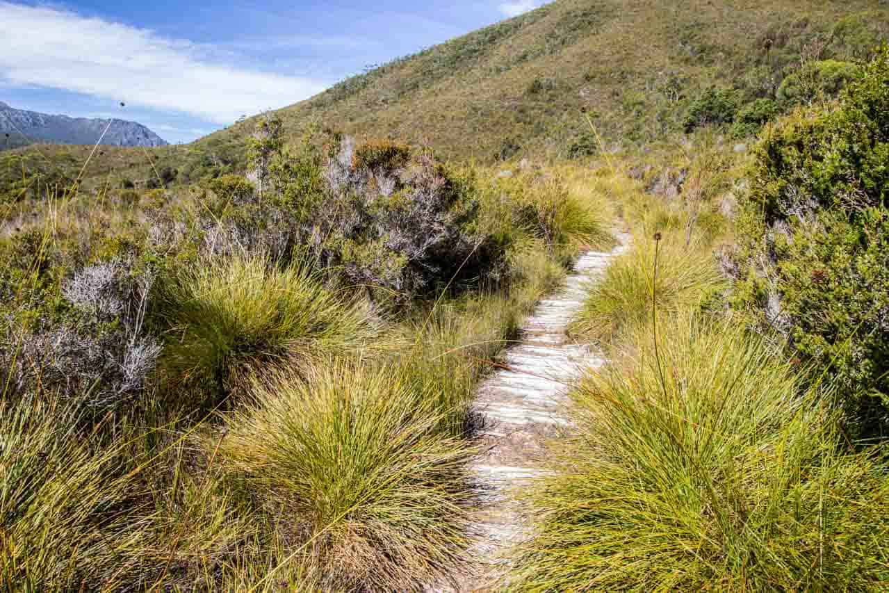
Heading south from the Lonely Tarns, the trail passes to the east of Mount Sarah Jane before steeply descending almost 2,000 ft / 600 m. I found the trail here incredibly overgrown and difficult to follow at points, so pay attention, as you will have little visibility in the tall brush. At the bottom, you hit the Anne River, which the trail follows to a turnoff for Lake Judd. Following the Lake Judd Track, the circuit continues west through the button grass plains. Expect mud.
The track isn’t too difficult to follow, and you’ll even find the occasional boardwalk (especially after passing the turnoff for Lake Judd). That said, I did get turned around once in some trees and had to backtrack a bit (but I’m probably just dumb). Also, you probably won’t see many people over here (I saw none) since the route heading up to Mount Anne is a far more popular option than slogging through the mud to Lake Judd.


Eventually, you cross a bridge over the Anne River and end up back at Scotts Peak Road at Red Tape Creek Trailhead (this is also the trailhead for the Lake Judd Track). Just north of where you pop out of the brush at the road, on the other side of the road (the west side), there is space for parking (if you want to leave a car or start the track here).
If you were smart (and you have two vehicles), you might have left a car waiting for you somewhere around here (there’s not great parking like there is at Condominium Creek further north). You can now either walk or hitchhike the 5.1 mi / 8.2 km back up to Condominium Creek (walking while hitchhiking is probably your best option). Alternatively, if you aren’t ready to end the adventure, you can head south toward 5.34 / 8.6 mi to Huron Campground and the start of the Western Arthurs Traverse.


Mount Anne Circuit Map
This is a GPS track for the Mount Anne Circuit online. This track should be used for illustrative purposes only and not for navigation. I’ve marked the peaks referenced in this post and the campsites that are marked on the TASMAP maps (links to these maps are at the end of this post).
Conclusion
I loved the Mount Anne Circuit and would definitely do it again. Sunrise on Mount Anne from Shelf Camp was awesome, and scrambling up to the summit and around The Notch and Mount Lot was lots of fun. That said, I had perfect weather and don’t know if I would feel the same way if I had done this in the rain (I most certainly would not feel the same way).
If you’re in Tasmania, especially if you’re considering doing the Western Arthurs Traverse, consider the Mount Anne Circuit. And if the entire circuit scares you, then you can do Mount Anne as a day hike or as an overnight and sleep at Shelf Camp (do this one).
I’m always looking to improve this information, so if you have any suggestions to improve or update this information, then please leave a comment below or get in touch.
Mount Anne Circuit Resources
- Tasmania Parks Pass
- Register for Mount Anne Circuit
- Mountain Forecast: Mount Anne
- Southwest National Park
- TASMAP Mount Anne Walk Map
- TASMAP Anne 1:25000 Topographic/Cadastral Map


Do you need to have experience climbing to complete this circuit?
You need experience or to be comfortable with Class III/IV exposure to complete this circuit.
Thanks for the info. Two things – what date did you walk and how long would you say it took to walk from Loney Tarns / Judds Charm to Red Tape Ck carpark? Cheers, Kerry
I walked this at the end of February. I’m not sure how long that stretch of trail took.
Take a rope! One person’s experience under one set of conditions does not cover the range of wet/slippery/snow/icy conditions that are common. The advice to take a rope is widely agreed and established with hikers (and rock climbers) who are experienced in Tasmanian conditions.
Yes, some people in some conditions will need a rope. However, other people in other conditions will find no use for one.
Learn how to use the rope before you take it.
Otherwise it’s probably more dangerous than not having a rope!
Always good advice!
Love this review and detail-specific helpful advice for how to do it – thank you :)
Happy to help!