Guide to Hiking Frenchmans Cap in Tasmania
Frenchmans Cap is the most prominent peak in Franklin-Gordon Wild Rivers National Park and located south of Tasmania’s Lyell Highway between Queenstown to the west and Derwent Bridge (where most people finish the Overland Track) to the east.
As a side trip (or as a continuation if you have a packraft or off-trail navigation skills), you can continue on the Frenchmans Cap track to Irenabyss where the trail runs into the Franklin River (there is camping here). You can (apparently) packraft down the river or cross it and continue out to Lyell Highway via the Raglan Range (there is no trail here). I haven’t done either of these things, but if you’re feeling adventurous and want to extend your Frenchmans Cap trip, these might be worth looking into.

Frenchmans Cap Basics
Frenchmans Cap is a relatively straightforward out-and-back to the 4,744 ft / 1,446 m summit of, you guessed it, Frenchmans Cap. The track has a “recommended time” of three to five days, but I would suggest doing it in two (a long one-day trip would be possible). There are two unstaffed and well-equipped huts along the trail (that is, they have tables, bunks, windows, and stoves – they’re not just wooden shacks that are going to blow down with a strong gust of wind) – Lake Vera Hut (20 bunks) and Lake Tahune Hut (24 bunks).
- Location: Franklin-Gordon Wild Rivers National Park, Tasmania
- Roundtrip Length: 33.55 mi / 54 km
- Type: Out-and-back
- Officially Recommended Time: 3 to 5 days
- My Suggested Time: 2 days
- Possible Time: 1 day
- Booking Required: Yes (link)
- Booking Cost: A$0
- Permit Required: Tasmania Parks Pass (buy)
- Permit Cost: A$12-$60
- Trailhead Location: South of Lyell Highway (A10) – -42.208706, 145.980739
- Elevation Gain: 3,280 ft / 1,000 m*
- Highest Point: 4,744 ft / 1,446 m
- Difficulty: Moderate
- Notes: If you read anything about the “Sodden Lodden,” you’re reading an old trip report – the trail has improved and is in better shape now.
*This number is not exact and is approximated from maps.


Registration
Hikers are required to register before departing the Frenchmans Cap Trailhead.
You can register for the Frenchmans Cap Track here.
A maximum of ten people are permitted to depart each day, and you’re limited to spending a maximum of three nights on the track. When staying at Vera and Tahune Hut sites, you are required to move on to the next campsite the following day.
How to Get to Frenchmans Cap
- Accessible via public transportation: Yes
- Trailhead parking: Yes (free, unmetered)
- Trailhead coordinates: -42.208706, 145.980739
BY CAR: Via car, the Frenchmans Cap trailhead is 124 mi / 200 km from both Launceston and Hobart, 35 mi / 57 km east of Queenstown, 18 mi / 29 km west of Derwent Bridge, or 34 km from Lake Saint Clair (the southern terminus of the Overland Track). The entire way to the trailhead is on sealed roads – except the parking area, which is dirt. The parking has room for probably around twenty cars and is free and unmetered parking.
BY TRAIN: Sorry, no trains.
BY BUS: The good news? There is a shuttle/bus that stops at the trailhead. The bad news? It’s infrequent and expensive, depending on where you’re coming from. You want the West Coast Connector Service from the Area Connect shuttle. It runs from Hobart to Queenstown, making stops in Hobart, New Norfolk, Gretna, Hamilton, Ouse, Bronte Junction, Derwent Bridge, and then Queenstown. From Hobart, a one-way ride will cost you A$55.70. There is only one bus per day in each direction on Tuesday and Thursday. A ride from Hobart takes nearly four hours. Here are the West Coast Connector Service timetable and the Area Connect website.
BY PRIVATE TRANSPORT: Several companies in Hobart and around Tasmania offer transport to/from trailheads. If you’re up for shoveling out a bit of cash for a ride, go for it.
HITCHHIKING: Hitchhiking to the start of the Frenchmans Cap Traverse is possible. There is a fair amount of traffic on this road (for Tasmania), and in my experience, hitchhiking around the island has been relatively easy.
Notes On Frenchmans Cap
The following are some notes to help you more easily understand exactly what I’m saying in this post, since when I was doing my research I found things to be a little confusing.
- As noted above, the “Sodden Lodden” is no more, and the trail is in better condition than it once was. There may still be mud at some points, but don’t expect to be wading through a river of it up to your waist.
- There are two unstaffed huts on the Frenchmans Cap Track – Lake Vera Hut (20 bunks) and Lake Tahune Hut (24 bunks). Both huts are in good condition and have camping available nearby.
- There is plenty of suitable camping along the Frenchmans Cap Track – camping options are not limited to the huts.
- There are no fires permitted anywhere along the Frenchmans Cap Track.
- Tasmania is notorious for its unpredictable and quickly changing weather. Make good decisions.
- There are composting toilets at both of the huts.
- The fungus, phytophthora cinnamomi, is rampant in Tasmania and kills native plants. The Frenchmans Cap Track is free of this fungus so be sure to clean your shoes, gaiters, trowel, etc. before hitting the track.
- I try to write things correctly, and despite my instincts telling me that “Frenchmans Cap” should be “Frenchman’s Cap,” it’s written without an apostrophe on all of my maps, the Tasmania National Parks website, and on other sources I consider “official” (this, of course, includes Wikipedia). So if the missing punctuation bothers you, don’t get upset with me.


Frenchmans Cap Itinerary
The suggested Frenchmans Cap Traverse itinerary calls for three to five days. Five days would be an incredibly leisurely pace as the entire track is only 28.58 mi / 46 km. I completed the track in two days. A one-day trip would be possible if you wanted to go for it. Most people might be most comfortable with three days (but personally, I would recommend at least two).
Here are some example itineraries:
- Day 1: 10 mi / 16.1 km – Trailhead to Lake Vera Hut
- Day 2: 2.8 mi / 4.5 km – Lake Vera Hut to Lake Tahune Hut
- Day 3: 3.23 mi / 5.2 km – Return to Lake Tahune Hut via Frenchmans Cap
- Day 4: 2.8 mi / 4.5 km – Lake Tahune Hut to Lake Vera Hut
- Day 5: 10 mi / 16.1 km – Lake Vera Hut to Trailhead
- Day 1: 12.8 mi / 20.6 km – Trailhead to Lake Tahune Hut
- Day 2: 6.03 mi / 9.7 km – Lake Tahune Hut to Lake Vera Hut via Frenchmans Cap
- Day 3: 10 mi / 16.1 km – Lake Vera Hut to Trailhead


If you’re interested in the approximate locations of Lake Vera and Lake Tahune Huts, you can find them here.
Frenchmans Cap Alternates
You can make a couple of side trips and variations on the Frenchmans Cap Track if you’re feeling adventurous.
Irenabyss: From the junction for Frenchmans Cap, you can continue north and descend nearly 3,280 ft / 1,000 m to Irenabyss. Once there, you can either turn around and head back out to the Frenchmans Cap trailhead or cross the river and cross the Raglan Range back to the Lyell Highway. The latter is best suited for those with lots of experience and navigation skills, as there is no official track leading out this way (and it involves a potentially hazardous crossing of the Franklin River. There is suitable camping at Irenabyss if you decide to extend your trip. (Map)
White Needle and Philps Peak: From Barron Pass on the Frenchmans Cap Track (the pass you reach after passing Lake Vera), there is a 1.62 mi / 2.6 km unmarked route up to White Needle (3,665 ft / 1,117 m). From here, you can follow the ridge to Philps Peak (4,206 ft / 1,282 m) and then either return to Barron Pass the way you came or you can continue southeast, east, and then northeast to loop back around and meet the Frenchmans Cap Track near Rumney Creek. The climb up to White Needle/Philps Peak is a scramble, and the loop back should only be attempted by experienced hikers. (Map)
Tahune Hut Ridge: From Tahune Hut, you can follow an unmarked route southeast up a steep scramble to a ridge above the lake offering views of the face of Frenchmans Cap. Do not attempt this route unless you’re comfortable scrambling. (Map)


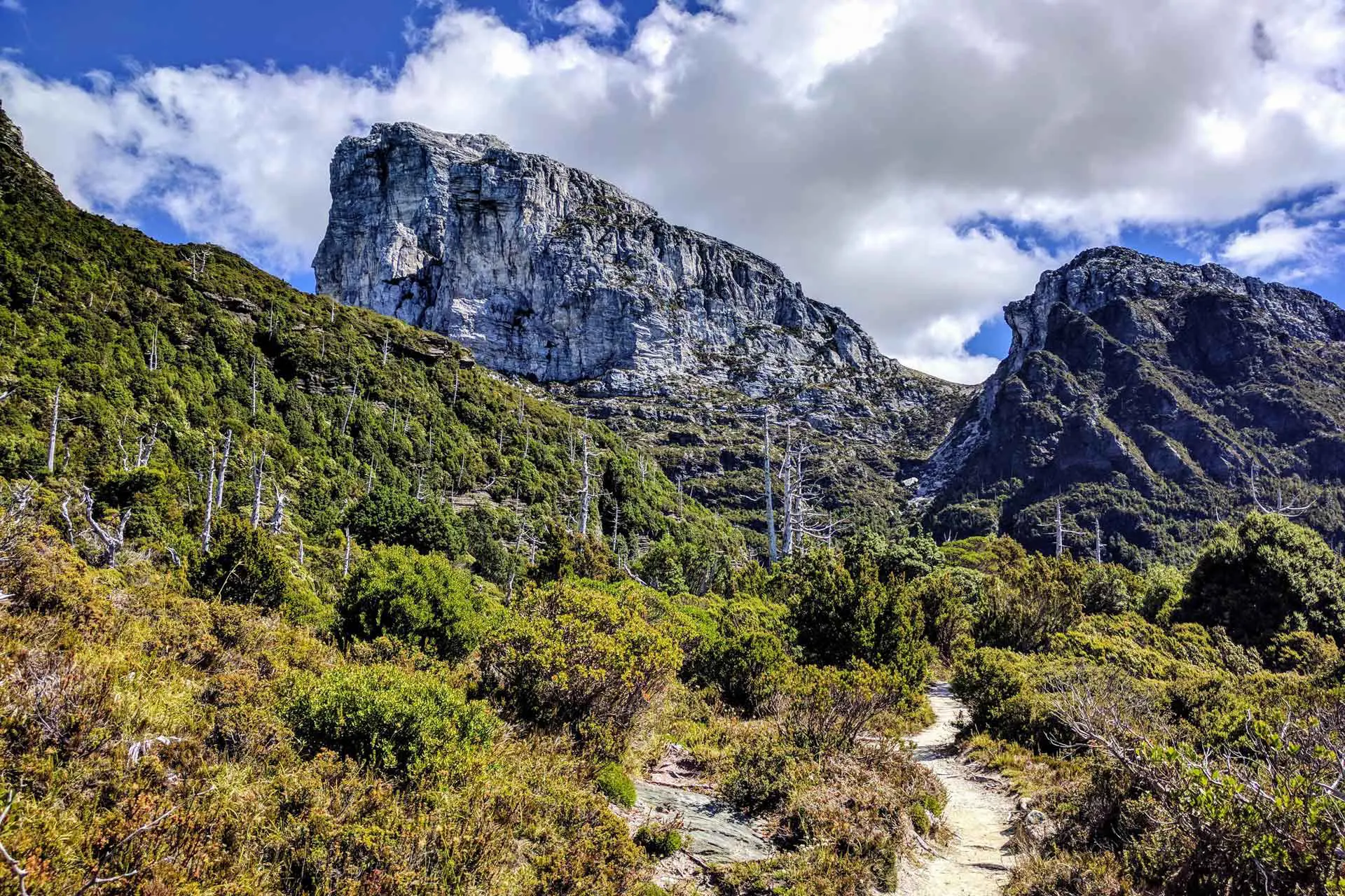
Frenchmans Cap Track
Leaving the parking lot, the track heads down to a walker registration point at the Franklin River. Cross the river via a suspension bridge and climb up a well-defined track to a pass at around 1,969 ft / 600 m. From here, if the weather is nice, you can catch your first glimpse of Frenchmans Cap (but don’t go photo crazy because you will get much better views).
The trail descends and flattens as you head through a button grass-filled plain before crossing the Loddon River via another suspension bridge. Some good campsites are on both sides of the river if you’ve already exhausted yourself. On a side note, when I came through here, two elderly hikers warned me to be careful because they “saw two snakes yesterday”. Yes, there are snakes here. You telling me to be careful because you saw some does not help me. The snakes are here whether we see them or not. This is me warning you about snakes. Don’t be freaked out about them; just know they exist (and are going to kill you).
The trail through here is a mostly flat boardwalk (I am pretty sure this is where the Sodden Lodden once was – if you don’t know what that is, don’t worry, it’s unimportant). You’ll catch another glimpse of Frenchmans Cap before reaching Lake Vera and the Lake Vera Hut. Inside the unstaffed hut, you’ll find some bunks, a stove, a trail register, all the garbage random reading material hikers leave behind, and the usual “crap you find in backcountry huts” stuff. Nearby are some platforms for tenting and more nice campsites on the other side of an outlet you cross.


The trail follows the lake before climbing steeply up to Barron Pass (3,110 ft / 948 m) to the west. You’ll find some orange arrows marking the way, but the trail isn’t difficult to follow (just a bit steep). From the pass, you have a great view of Frenchmans Cap along with Lake Cecily and Lake Gertrude below. And, if you’re up for it, you can scramble up to White Needle (3,665 ft / 1,117 m) or Philps Peak (4,206 ft / 1,282 m) to the south of Barron Pass.
You then get a nice northwest traverse below the ridge and up to a lookout over Artichoke Valley before descending to Lake Tahune and the Lake Tahune Hut. When I hiked through, major renovations were going on at the Lake Tahune Hut. I was not able to enter, but according to the Tasmania Parks and Wildlife Service, the hut has a composting toilet, accommodates 16 people, and is “passively heated with a fixed background temperature” (supposedly the hut has “high thermal properties designed to retain heat”).


From Lake Tahune Hut, it’s nearly 1,476 ft / 450 m up to the summit of Frenchmans Cap over a steep 1.62 mi / 2.6 km climb. Plenty of cairns dot the northern slope, but as long as you go up, you’re going the right way. At the summit, there is (or at least was) a small windbreak made of rocks and excellent views in all directions (but particularly to the south) if you’re lucky enough to have good weather.
The summit is large and open – perfect for watching the sunrise or sunset.


Frenchmans Cap Conclusion
If you’re hiking the Overland Track, Frenchmans Cap would be a great track to do once you finish the Overland at Lake Saint Clair (you can even catch the bus from there if you’re not keen on hitchhiking or paying for a pickup).
If you think you’ve got the weather window, Frenchmans Cap as an overnighter is a great option for a shorter Tassie hike. If I make it back, I will probably head down to Irenabyss next time to explore the Raglan Range (or I’ll bring my packraft…and someone who knows what they’re doing with it).
I’m always looking to improve this information, so if you have any suggestions to improve or update this information, then please leave a comment below or get in touch.


Frenchmans Cap Resources
- Tasmania Parks Pass
- Frenchmans Cap Track Registration
- Australia Bureau of Meteorology
- Franklin-Gordon Wild Rivers National Park
- Area Connect Bus/Shuttle Service
- West Coast Connector Service Timetable
- Tassielink Bus Information and Timetables
- TASMAP Frenchmans Cap 1:50000 Topographic Map


Did the Raglan range loop you mention but in the opposite direction about 14 years ago. Parked in Frenchies car park, Stashed bikes in bush near road at Raglan range end. A fair bit of bush bashing as there is no track after Flat Bluff. Finding the pad down to the Irenabyss was frustrating in 35 degree heat, but doing the first and probably only inflatable-Homer-Simpson-armchair-supported nude crossing of the Franklin river was a highlight
That’s quite the highlight!
Parks request no camping on the summit, its not ecologically sustainable. I appreciate you had a great experience but it would be good if you could use your influence to note that it is not a good idea.
I can’t find anywhere on the Tasmania Parks (on the Franklin-Gordon Wild Rivers National Park or Frenchmans Cap pages) where this is stated, could you please provide me with a source for this?
This request from Parks is written in the Tahune Hut on an official board. And you should not ask for a source as this should be obvious to any experienced hiker. If you wanted to verify, please contact Parks and I am sure they can send you a photo / copy of the board and confirm Sarah’s request. They request you don’t camp at the top (with or without tent) as it is not ecologically sustainable. You have been on the top, you have seen this would not be an environmentally sustainable site. I agree with Sarah, please encourage your readers not to camp on the top. This is now a very busy / popular hike. If lots of people camp at the top this would be a disaster for the fragile environment. Please use your influence for the good and encourage people to do the right thing. And don’t mention you camped there as an option for people at all.
Just came back from Frenchmans and it was amazing! I did it in 3 days, midday first day to midday third day, staying at Vera both nights.
However I met several groups who took more than 6 hours to walk from the trailhead to Vera. These groups would have no chance of completing the walk in 1-2 days.
So if you’re reading this, please note 1-2 days is only for very fit people! For most, around 4 days is more realistic.
You’re certainly right. Three or four days is a more realistic pace for many people. That said, a one or two-day trip is still possible :)
4 days gives you two chances at the summit. It’s about 3.5 hours to the carpark from either Launceston or Hobart. Arrive before midday. Get yourself to Vera for the first night. It probably wont take you 5 hours from the carpark, but I’d allow that. Then Vera to Tahune next Morning (again, 4 or 5 hours) and Summit if the weather’s good (it wasn’t, extravagantly so). Otherwise Summit next morning and back to Vera that evening. Even if the summit remains cloudbound the walk from Vera to Tahune is just amazing. More impressive than the peak in many ways.
The new Lake Tahune Hut was completed in 2018 and sleeps 24, not 16.
Thanks for the update! I’ve made the changes.
We seem to share a liking to camping on summits! :)
Some of the best places to camp (but not to poop).
I once had to poop on a flat rock and frisbee it into a deep crack while on a summit. Not my proudest moment but it was coming and it had to go somewhere!
At least you did a responsible high-alpine poop.
I camped in that exact same spot last summer
Excellent spot!
Thanks for the report. It seems that this Tassilink bus no longer exists.
Thank you for pointing this out. The post has been updated!
Hey Mac. What month did you hike for such good weather?
I did this in March.