Timberline Trail Backpacking Guide
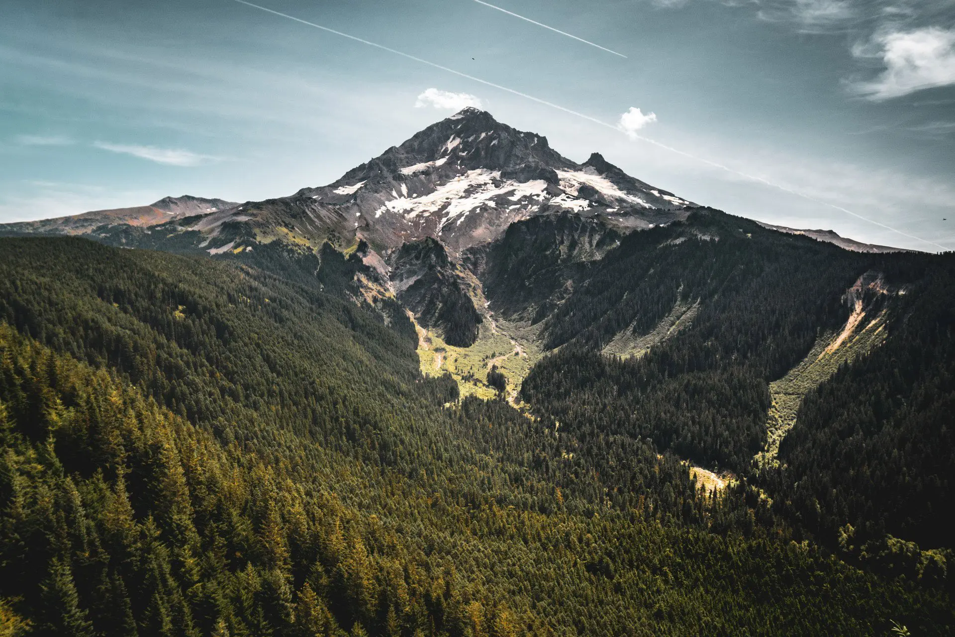
The Timberline Trail is a 41.5-mi / 66.8-km loop encircling the 11,250 ft / 3,429 m Mount Hood (called Wy’east by the Multnomah tribe) in Northern Oregon. The trail is commonly started from Timberline Lodge on the southern side of Mount Hood, but there are a number of different trailheads that provide access to the Timberline Trail; two of which, Cloud Cap Trailhead and Top Spur Trailhead, are practically on the trail.
A typical hiker would likely want three or four days to complete the circuit, but it can be done in as little as one day. Regardless of trip length, a self-issued permit is required for hiking in the Mount Hood Wilderness; these permits are available at the trailheads (or shortly down the trail from the trailheads).
Hiking the Timberline Trail requires multiple river crossings (most unmaintained and without permanent infrastructure), and dips in and out of glacial drainages amounting to 10,875 ft / 3,315 m of elevation gain for the trail.


Timberline Trail Basics
- Location: Mount Hood, Oregon
- Length*: 44 mi / 70.8 km
- Type: Loop
- Officially Recommended Time: 3-4 days
- My Suggested Time: 2-3 days
- Possible Time: 1 day
- Max Group Size: 12
- Booking Required: No
- Booking Cost: $0
- Permit Required: Yes (May 15 to Oct 15)
- Permit Cost: $0
- Mount Hood Summit Location: 45.373550, -121.695909
- Trailhead Locations:
- Timberline Lodge (south)
- Cloud Cap Trailhead (northeast)
- Top Spur Trailhead (northwest)
- Elevation Gain*: 10,875 ft / 3,315 m
- High Point: 7,350 ft / 2,240 m (eastern slopes of Mount Hood)
- Low Point: 3,262 ft / 994 m (western slopes of Mount Hood)
- Difficulty: Moderate


How To Get There
The easiest way to reach the Timberline Trail is by car, but there are public transportation options as well (public transportation limits you to beginning at the Timberline Lodge trailhead). The closest cities to Mount Hood are Government Camp, Oregon and Hood River, Oregon, but it’s possible to reach Timberline Lodge from Portland or Bend via public transportation.
- Accessible via public transportation: Yes
- Trailhead parking: Yes
- Trailhead locations:
- Timberline Lodge (south)
- Cloud Cap Trailhead (northeast)
- Top Spur Trailhead (northwest)
BY CAR: Getting to one of the trailheads for the Timberline Trail via car is straightforward as all of the roads are paved and maintained. The closest trailhead to Portland is practically equidistant from the Top Spur Trailhead and Timberline Lodge, Bend is closest to Timberline Lodge, and Cascade Locks/Hood River are nearly equidistant from Top Spur Trailhead and Cloud Cap Trailhead.
NOTES ON PARKING: If you’re leaving a vehicle at a trailhead (with the exception of Timberline Lodge), you will need to display a Northwest Forest Day Pass ($5/day), an Annual Northwest Forest Pass ($40), or an America the Beautiful Pass ($80) while you’re parked.
BY BUS (FROM PORTLAND/HOOD RIVER): You can find bus service to the Timberline Trail via the Mount Hood Express (sorry, they have a horrible website). You can catch the Mount Hood Express in Sandy, Oregon Collins Lake Resort & Government Loop if coming from Bend. If you want to take public transportation from Hood River, you will have to go all the way back through Portland. From Portland, you can take the TriMet bus to the Gresham Transit Center and then transfer to the Sandy Area Metro Bus to the Sandy Transit Center in Sandy, Oregon, and then transfer to the Mount Hood Express.
BY BUS (FROM BEND/REDMOND): From Bend, you can also reach the Timberline Trail via the Mount Hood Express (again, they have a horrible website). Take the bus north from Hawthorne Station in Bend to Redmond Hub in Redmond. From there, you can take the Central Oregon Breeze to Collins Lake Resort & Government Loop where you can catch the Mount Hood Express.
HITCHHIKING: As I understand it, hitchhiking in Oregon is legal so long are you are not on/in the actual road (like where you could drive a car). Apparently, it’s also legal to walk on freeways (but you should not do this); that said, stick to on-ramps. If you can, I would suggest catching a bus out of the city before you begin hitchhiking to increase your chances of a ride. The closer you get to Mount Hood, the easier rides should come.


Notes on the Timberline Trail
The following are some notes to help you more easily understand exactly what I’m saying in this post since when I was doing my research I found things to be a little confusing.
- Campfires are prohibited within 500 ft / 150 m of Ramona Falls and McNeil Point, within the tree-covered island in Elk Cove and Elk Meadows, and in Paradise Park.
- Camping is prohibited in all meadows, within the tree-covered islands of Elk Cove and Elk Meadows, and within 500 ft / 150 m of Ramona Falls.
- Historically, the Newton, Eliot, Coe, Muddy Fork, Sandy, and White Rivers are the most challenging fords but they are usually no more than knee-deep.
- Permits are free and available at trailheads (or shortly down the trail from the trailheads).
- Water found along the Timberline Trail should be treated before consumption.
- Cloud Cap Trailhead, Top Spur Trailhead, and Ramona Falls Trailhead require a day-use fee of $5 per day between May 15 and October 15 (for parked cars). You can purchase day passes for $5 each or an Annual Northwest Forest Pass for $30. The America the Beautiful Pass ($80) also covers these trailheads.
- There was a large washout at the crossing of Eliot Branch in 2016 – this has been rerouted to cross downstream of where the trail previously crossed Eliot Branch. There is no bridge across the Eliot Branch where the Timberline Trail crosses (map of reroute). This reroute requires no additional navigation and you need simply to follow the trail as you would normally.
- I did the Timberline Trail in a single clockwise from Timberline Lodge. However, if I were to go back and do it over (in a single push), I would go counterclockwise. I thought the trail on the eastern side of the circuit to be more difficult and the river crossings to be more attention-deserving.


Timberline Trail Camping
The most popular starting point for the Timberline Trail is Timberline Lodge (probably because of free parking, multiple restaurants including a breakfast/lunch buffet, and flushing toilets). Most people hike the trail clockwise, but if you’re leaving from Timberline Lodge and plan on doing the hike in a single day, I recommend heading counterclockwise.
Dispersed camping is permitted in the Mount Hood Wilderness with the following restrictions: no camping in meadows, within the tree-covered islands of Elk Cove and Elk Meadows, and within 500 ft / 150 m of Ramona Falls.
Bar any additional fire ban that may be in place at any given time, campfires are prohibited within 500 ft / 150 m of Ramona Falls and McNeil Point, within the tree-covered island in Elk Cove and Elk Meadows, and in Paradise Park. If you’re looking for a campsite with bathroom-going facilities, you can find a pit toilet at Cloud Cap Saddle Campground at the Cloud Cap Trailhead (northeast section of the circuit).
So find awesome campsites and just remember to not be a dick and to camp 200 ft / 60 m from lakes and streams and on durable surfaces.


Timberline Trail Gear
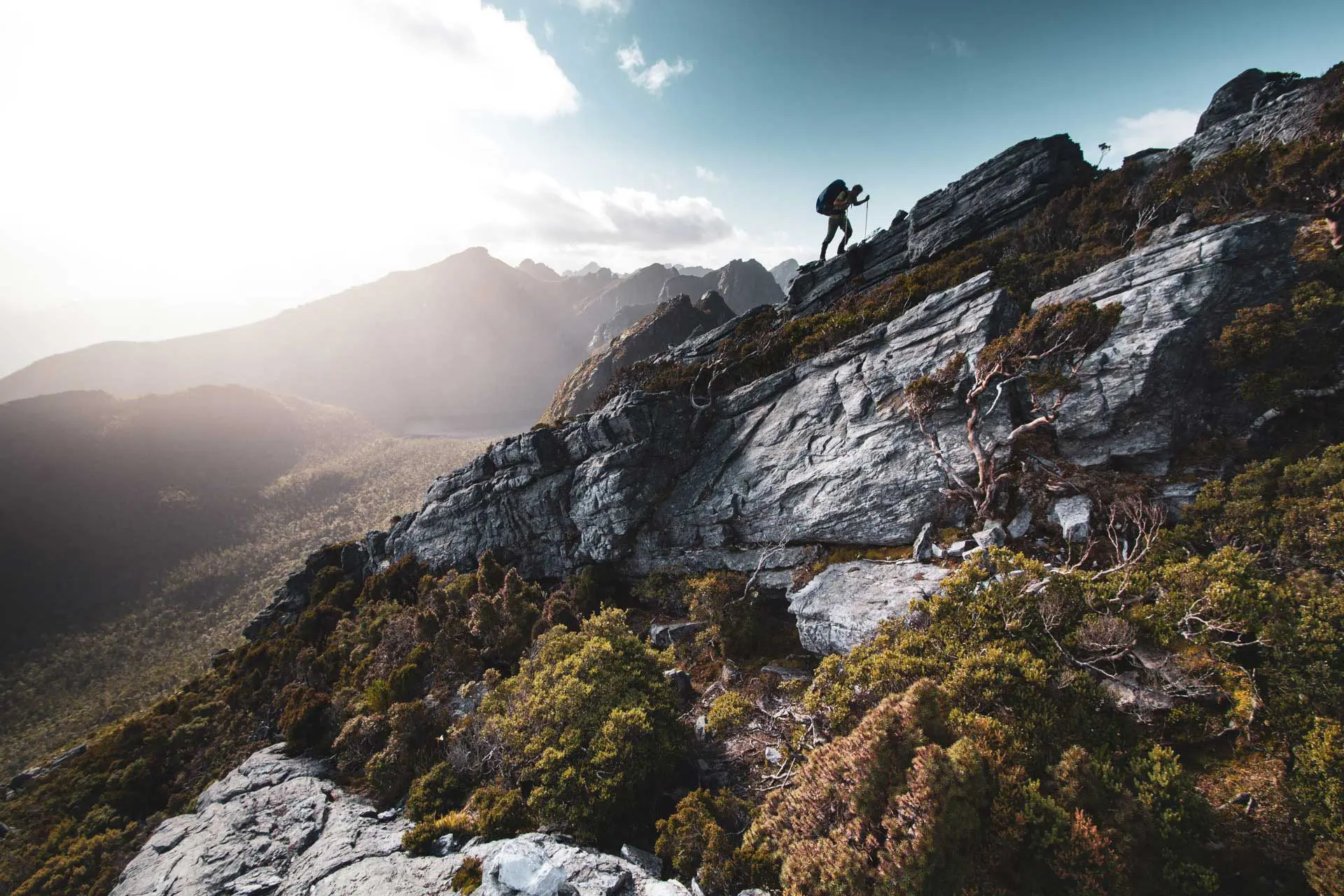
The Timberline Trail isn’t long enough to be considered a long-distance backpacking trip (personally, I think the threshold for this sits at 500 mi / 800 km), but as a three or four-day trip, it could easily be a long backpacking trip if you haven’t had a ton of experience on the trail.
You’ll need If you don’t know what you should be packing for a trip like this, you probably shouldn’t be hitting the Wonderland Trail, but there are a few things that are worth highlighting/pointing out just in case.
- At all the Timberline Trail trailheads (with the exception of the Timberline Lodge Trailhead), you are required to have a Forest Pass valid for each day your vehicle is parked. You can purchase either day passes for $5 each or an Annual Northwest Forest Pass for $30 (valid at Columbia River Gorge, Colville, Deschutes, Fremont-Winema, Gifford Pinchot, Malheur, Mount Baker-Snoqualmie, Mount Hood, Ochoco, Okanogan, Wenatchee, Olympic, Rogue River-Siskiyou, Siuslaw, Umatilla, Umpqua, Wallowa-Whitman, and Willamette National Forests for one year from the issue date).
- Having a map of the area you’re hiking in is always handy (for killing mosquitoes or burning for warmth if nothing else) – the National Geographic Mount Hood Wilderness Topographic Map has everything you need for a Timberline Trail hike.
- Depending on the time of year and your ability to balance on logs and rocks, you might be getting your feet wet at some point during the Timberline Trail – a pair of waterproof socks might be a handy thing to have.
- There are a handful of shelters along the Timberline Trail, but I would recommend bringing a shelter (tent) as the camping opportunities are plentiful.
- If you’re hiking during the summer, repellant is a wise investment; I am a big fan of Sawyer Picaridin Spray.
If you want more recommendations on backpacking gear, check out my current gear list or gear reviews.


Timberline Trail Description
The Timberline Trail is well-maintained, but not quite to the same level as something akin to the Wonderland Trail (the Mount Hood Wilderness doesn’t have those national park dollars).
The condition of the trail is generally quite good. On the eastern side of Mount Hood, there are a few sections of trail where the path can be a bit more difficult to pick out and it is marked by large (or sometimes small) cairns. There are also a few river crossings where you’ll have to be comfortable not being on a defined trail as you will likely have to search out the best place to cross (and then find the trail again on the other side of the crossing).
Signage on the Timberline Trail is solid, but you won’t, for example, encounter signs at every river crossing telling you where you are and what to expect ahead. Practically all of the trail junctions are marked and so long as you have some vague understanding of where you are on a map (here’s a map), you won’t have any trouble following the trail.
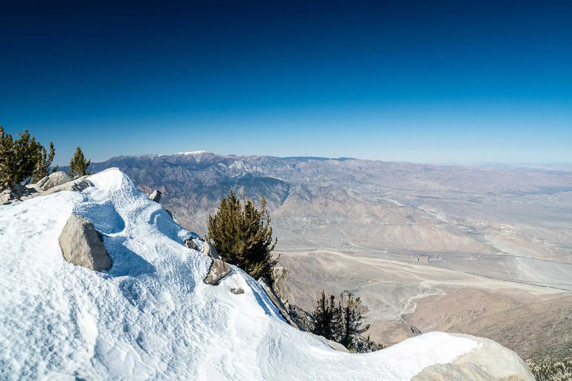
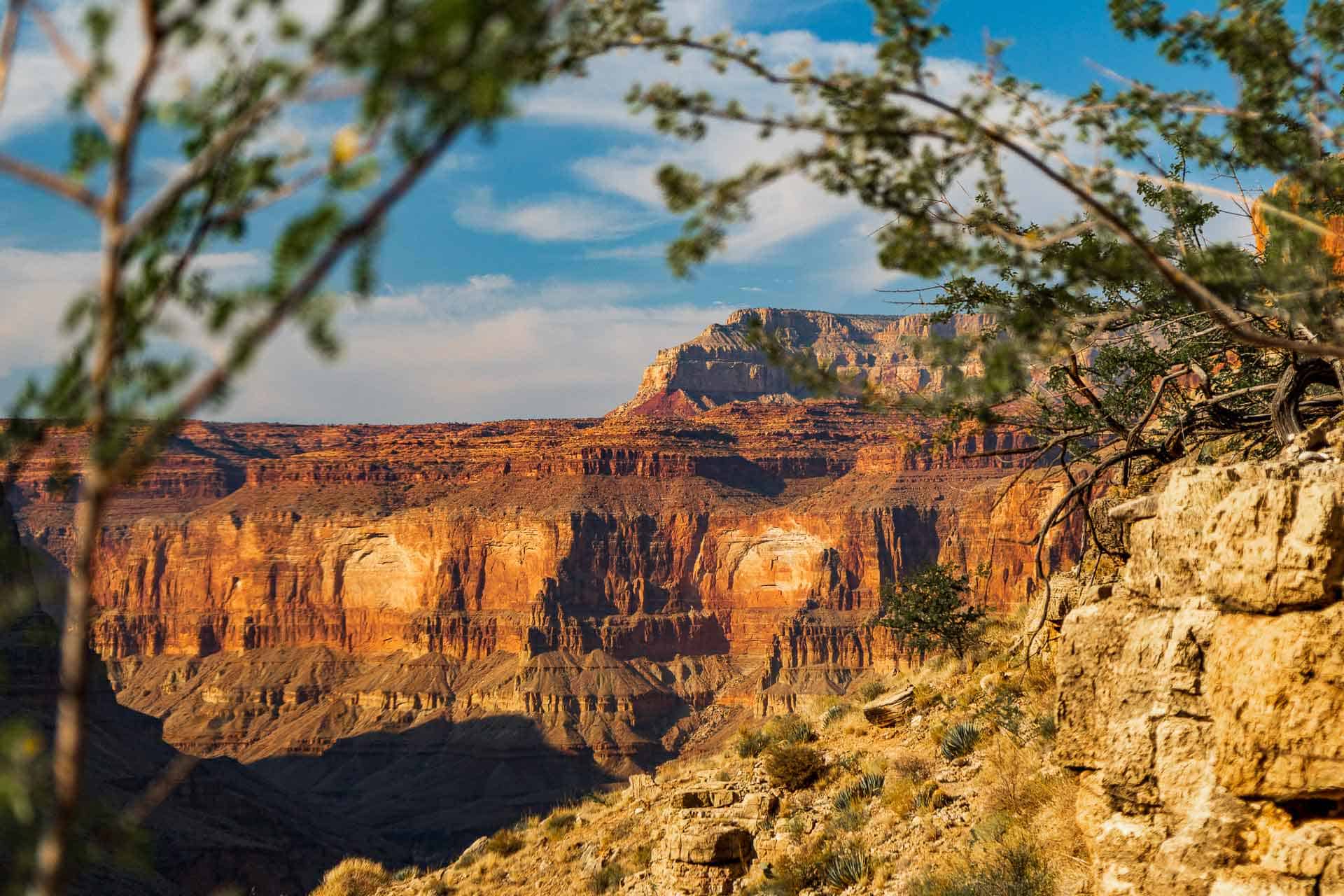
The highlights on the Timberline Trail would have to be (excluding the buffet at Timberline Lodge), Ramona Falls (a neat waterfall but nothing mind-blowing), the Paradise Park Loop alternate (between Timberline Lodge and Ramona Falls), and Mount Hood itself. I enjoyed the eastern half of the loop best.


Timberline Trail Map
This is a GPS track for the Timberline Trail. This track should be used for illustrative purposes only and should not be used for navigation. I’ve marked the trailheads and river crossings referenced in this post. If you would like a paper map of the Mount Hood Wilderness, you can find it here.
Conclusion
The Timberline Trail is certainly worth the effort. It’s not as crowded as some of the other bit-ticket trails and as a result, does not (yet) require a permit reservation or lottery (but this could change in the future).
I would hike the Timberline Trail again, but I would do it as a two-day trip instead of a one-day push. Remember, that if you start somewhere that’s not Timberline Lodge, you can grab yourself a mid-hike meal (or even a hotel stay). If you plan it right you might even be able to do the entire Timberline Trail without having to dig a cathole! (That’s a hole for pooping in.)
I’m always looking to improve this information, so if you have any suggestions to improve or update this information then please leave a comment below or get in touch.
Resources
Affiliate Disclosure: This page may contain affiliate links, which means I may receive small commissions for purchases made via these links at no additional cost to you. This helps pay the bills and keep the site up and running. Thank you for your support!

I’ve passed this around to locals and they love it! A friend commented, and agreed, it’s comprehensive without getting too buried in incidental details.
Properly sequential — the public transportation section is critical for anyone local, or perhaps visiting nearby. Why in the hell they have not developed more streamlined, affordable options for getting to Timberline, Govy, and Mt. Hood Meadows, directly from points within Portland (not Sandy!), is beyond me. Light rail from the suburbs to Portland, hop on shuttles in Portland coming and going from the mountain. Bingo! Less congestion. Too easy, too simple. The mountain sees lots of year-round recreational use now, so I assume the passengers are there to make it work. Instead, we prefer whining about the congestion along the Mt. Hood Highway and pump more cash into adding more pavement, sturdier guard rails, and massive center islands to prevent more head-on collisions. On popular weekends, it’s a conga line of cars going up, and down. Add winter conditions outside hiking season and it’s a super fund site for hazardous driving.
My personal favorite area is Cloudcap — in part because of the history. Cloudcap Inn was the first “hotel” developed on the mountain. It’s been maintained for decades now by the oldest SAR in America, The Crag Rats. The place would be lost without their efforts. They’ve used it as a base for lots of SAR training and real-time search / rescue objectives. My favorite day hike is the jaunt from Cloud Cap up to Tie In Rock. The trail meanders near the east lateral moraine, more or less. No trees, but lots of valley views and upfront with the Eliot glacier.
A feature that sets your guides ahead of the pack are, it’s serious with regard to proper and sound advice, but punctuated with characteristic humor. It’s a serious hike with potential risks, like any hike, but we’re out there to have fun and take a little respite from the grind, after all.
Thanks @lacorota:disqus! I also very much enjoyed the eastern side. Next time I’ll have to try your jaunt up to Tie In Rock.