
Guide to Hiking Federation Peak in Tasmania
Federation Peak is a remote peak in Tasmania’s Eastern Arthur Range. The 4,180 ft / 1,274 m summit is accessible via Farmhouse Creek to the east or Western Arthurs to the west. A full traverse of the Arthur Range and exit via Scotts Peak Dam is possible via Federation Peak (or “Feddy” as locals sometimes call it), but here I’ll be talking about hiking up to the summit from Farmhouse Creek. For more on the Arthurs, check out my Guide to the Western Arthurs Traverse.
The hike to Federation Peak is challenging and remote (it’s the most remote hike I’ve done in Tasmania). Before reaching the peak, you’ll need to climb an exposed area that requires the use of your hands. It’s not as dramatic as some photos make it out to be, but falling here would not be in your best interest (i.e., it might kill you).

Federation Peak Basics
- Location: Southwest National Park, Tasmania
- Roundtrip Length*: 24.85 mi / 40 km
- Type: Out-and-back
- Officially Recommended Time: 4 to 5 days
- My Suggested Time: 2 to 3 days
- Possible Time: 1 day (would be huge)
- Booking Required: Yes (link)
- Booking Cost: A$0
- Permit Required: Tasmania Parks Pass (buy)
- Permit Cost: A$12-$60
- Summit Location: -43.271576, 146.474932
- Trailhead Location: Farmhouse Creek (end of Picton Road) -43.231673, 146.668112
- Elevation Gain*: 4,265 ft / 1,300 m
- Summit Height: 4,180 ft / 1,274 m
- Difficulty: Strenuous
*These numbers are approximate

Registration
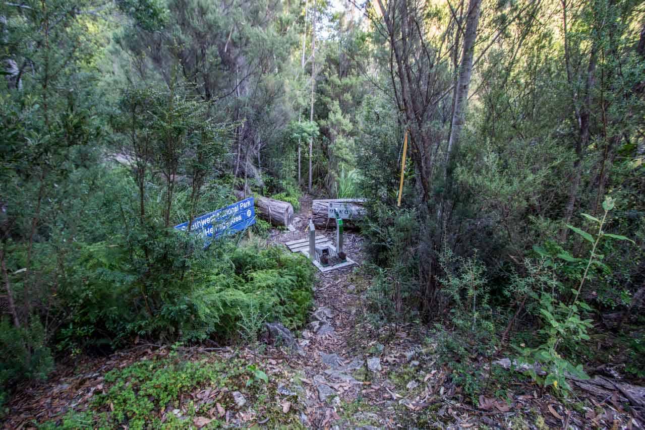
Hikers are required to register prior to departing the Farmhouse Creek Trailhead.
You can register for Federation Peak and Farmhouse Creek Track here.
There are a maximum of six people permitted to depart each day and you’re limited to spending a maximum of two nights at Bechervaise Plateau and/or Hanging Lake.
How to Get to Federation Peak
The Federation Peak trailhead at Farmhouse Creek is located 68 mi / 109 km southwest of Hobart. However, most roads are unpaved, so it will probably take two to three hours to get there via car (the only way to get there). Unfortunately, there is no public transportation to Farmhouse Creek, so you will probably have to rent a car or have a nice person drop you off if you wish to start your hike there. Although hitchhiking is technically possible, I wouldn’t recommend it as there’s a good chance you’ll be stuck waiting for a ride for a couple of days.
- Accessible via public transportation: No
- Trailhead parking: Yes (free, unmetered)
- Trailhead coordinates: -43.231673, 146.668112
By Car
Via car, the Federation Peak trailhead is 68 mi / 109 km southwest of Hobart. Much of this drive is on unsealed roads, which can take upwards of three hours. It’s a long drive I did at night (I would not recommend it), and you’ll have to take your time as the road isn’t well maintained. You’ll find parking when Picton Road ends (at least as far as cars can go), but the parking area only has room for maybe eight vehicles – it is free and unmetered.
By Train
Sorry, no trains.
By Bus
Sorry, no buses
By Private Transport
There are several companies in Hobart and around Tasmania offering transport to/from trailheads. If you’re willing to spend some cash on a ride, go for it (this one will probably cost you a lot).
Hitchhiking
Hitchhiking to the start of the Federation Peak is, of course, theoretically possible. However, this trailhead is extremely remote. I saw only three other parties during the two days I spent hiking Federation Peak. If you plan on hitchhiking, you will have to 1) bring plenty of extra food for the days you might spend waiting and 2) be very lucky to get maybe one car per day driving to the trailhead (if that).


Notes on Federation Peak
The following are some notes to help you more easily understand exactly what I’m saying in this post since when I was doing my research I found things to be a little confusing.
- The Cracroft River and the South Cracroft River can flood during heavy rain, making the track more difficult (the track crosses the South Cracroft and runs parallel to both for most of the track).
- No fires are permitted anywhere along the Federation Peak Track.
- Tasmania is notorious for its unpredictable and quickly changing weather. Make good decisions.
- There are no huts or toilets along the Federation Peak Track.
- The fungus phytophthora cinnamomi is rampant in Tasmania and kills native plants. Clean your shoes, gaiters, and trowel beforehand (there’s a shoe-cleaning station at the start of the track).
- You may read reports of people bringing rope for climbing and pack hauling on this track. This is not required, but don’t let me stop you from bringing any if that’s what you’re into.
- There are a number of named campsites along the track (though you will find no signs or markers as such, only flat, empty spaces): Crest Camp, Forest Camp, Paperbark Camp, and Cutting Camp (these are not the only camping opportunities, just the named sites).
- There are wooden platforms for tents on Bechervaise Plateau just below Federation Peak (there was also a water source available when I was there).


Federation Peak Itinerary
The suggested Federation Peak Traverse itinerary calls for three to five days. Five days would be an incredibly leisurely pace as the entire track is only 28.58 mi / 46 km. I completed the track in two days after spending the night at the halfway point – on top of Federation Peak. A one-day trip would be possible if you really wanted to go for it. Most people might be most comfortable with three days (but I would recommend two).
Here is an example itinerary:
- Day 1: 5.9 mi / 9.5 km – Farmhouse Creek to South Cracroft River crossing
- Day 2: 4.29 mi / 6.9 km – South Cracroft River crossing to Cutting Camp
- Day 3: 2.55 mi / 4.1 km Cutting Camp to Bechervaise Plateau via Federation Peak
- Day 4: 6.03 mi / 9.7 km – Bechervaise Plateau to South Cracroft River crossing
- Day 5: 5.9 mi / 9.5 km – South Cracroft River crossing to Farmhouse Creek
Here’s what I did:
- Day 1: 10.25 mi / 16.5 km – Farmhouse Creek to Cutting Camp
- Day 2: 4.35 mi / 7 km – Cutting Camp to Federation Peak (Return)
- Day 2: 10.25 mi / 16.5 km – Cutting Camp to Farmhouse Creek


Federation Peak Track
The trail leaving Farmhouse Creek begins innocently. You cross a bridge, there’s a clear path, there’s a shoe-cleaning station, there’s a lovely creek you walk next to, and there are plenty of pink ribbons and orange arrows marking the way – but this doesn’t last long. Let me tell you upfront: the trail to Federation Peak is probably the most poorly maintained trail I have ever been on. It’s muddy, overgrown, full of blowdowns, and not well-marked. Consider yourself warned.
The trail heads west, slowly climbing along Farmhouse Creek. At around the 3.11 mi / 5 km mark, you’ll pass an unmarked junction with a trail heading south that leads to Lake Sydney and Mount Bobs. If you have the time and are prepared (the tracks south of here are largely unmarked and undefined), then Mount Bobs looks like a worthy detour (around 8.45 mi / 13.6 km return).
Continuing on the Federation Peak trail, you’ll soon reach South Picton Saddle, where there’s an unmarked junction leading to Judds Cavern (an aboriginal sight that you’re discouraged from visiting). Continuing toward Federation, the trail descends southwest into a button grass-filled plain with views of Federation Peak (weather permitting).


The trail crosses the South Cracroft River (where there’s a nice campsite) and continues west through muddy button grass plains. Slowly climbing again, the trail crosses a ridge before descending to parallel the Cracroft River on the other side. It’s easy to get turned around on this track and once I even ended up unintentionally walking back the way I came after getting disoriented – so pay attention.
During this section of the trail, you’ll pass many suitable campsites. The final one, Cutting Camp, is a good place to end your first day if it’s getting late because the next section involves a slow and steep climb up Moss Ridge to Bechervaise Plateau (where there is both water and platforms for camping).
The climb up Moss Ridge is steep and filled with blowdowns. Sometimes, it looks like there’s no way forward, but it’s because you need to climb onto and walk along a fallen tree to the next section of the trail. Around halfway up, you’ll get some lovely views of Federation Peak, and the trail mellows out slightly (in terms of steepness). However, there are a few areas where you will need to use your hands for a bit of climbing.


From Bechervaise Plateau (now above treeline), the trail climbs west toward Federation Peak, but you’ll approach the summit from the south. After some climbing, the trail heads down through a narrow split in the rock before making a sharp right and heading up Chockstone Gully – an impossibly steep-looking chute with a rock jammed into the middle of it (a rock you will go under). Yes, this is where the trail goes next.
Climbing up this chute isn’t as difficult as it may look, and you even get to go underneath a big boulder pinched between its sides. Cool. There are some trail markers here, but there’s only one way up.


The trail continues to the final climb to the summit. There are (or were) a number of cairns here, but not all follow the same route. You can make it up to the summit without making any dangerous moves, so if you’re feeling uncomfortable at a certain spot, don’t be afraid to descend a bit and reevaluate (I had to do this as I picked the wrong way up the first time).
When you reach the summit you’ll find a logbook (I forgot to sign, sad face), and (if you’re lucky) awesome views in all directions.
If you want to extend the trip, you can hike to Hanging Lake from Federation Peak, where there are (supposedly) some suitable camping spots. Or, if you’re feeling badass, you could traverse the entire Eastern Arthur Range (as you’ve just done the first and probably most miserable section). When you’re ready to stop enjoying the summit, remember that you need to walk back through all that terrible trail you just walked in on. Have fun!


Federation Peak Gear
To reach Federation Peak, you’ll want a complete backpacking kit, especially if you’re planning to spend the night. Here are a few things you should make sure to include in your pack.
- Trowel: A good trowel is essential for a backcountry trip in Tasmania’s National Parks. The ground is not great for digging with your shoe’s heel, a rock, or a trekking pole. Please bring a lightweight trowel, dig proper catholes, and pack out your toilet paper.
- Satellite Messenger: A satellite messenger – like the Garmin inReach Mini 2 – is a highly recommended, potentially life-saving device for venturing into the backcountry – particularly to a place as remote as Federation Peak.
- National Parks Pass: You must purchase a National Parks Pass to enter and recreate in Tasmania’s National Parks. You can do this online and ahead of time. Might as well get it over with.
- Lightweight Gloves: A lightweight pair of gloves like the Ridge Merino Glove Liners is an excellent addition to your pack for Federation Peak. Even if you don’t typically hike with gloves, I recommend having something warm for the mornings and evenings or climbing the cold rock near the peak.
- Extra Socks: When hiking in Tasmania, carrying an extra pair of socks—not for hiking in but for putting on when you finish your hike—is a fantastic way to reward yourself for returning to the trailhead alive. Chances are, all the socks you brought will be soaking wet, so save that extra pair for the end.
- Gaiters: I don’t usually hike with knee-high gaiters, but the mud and leeches in Tasmania make me reconsider this while exploring the island. If you don’t already have a pair of long gaiters, I highly recommend getting some for your Tasmania kit.
Federation Peak Map
This is a GPS track that I found for Federation Peak online. This is not my GPS track. This track should be used for illustrative purposes only and should not be used for navigation. I’ve also marked the campsites that are marked on the TASMAP maps (links to these maps are at the end of this post).
Conclusion
Federation Peak is an awesome hike, and if you’re in Tasmania (and have the experience/confidence), then definitely try to do it (I know, getting out to the trailhead is a bitch). Be warned that the track is not an easy one. It’s overgrown, poorly marked, full of mud, and incredibly frustrating at times. However, if a friend was making a trip to Tasmania, I would recommend it.
If you’re feeling super badass, I would suggest that you turn this into a more extended trip by heading to Hanging Lake, Mount Bobs, or (ideally) a complete traverse of the Arthur Range.
I’m always looking to improve this information, so if you have any suggestions to improve or update it, please leave a comment below or get in touch.


Federation Peak Resources
- Tasmania Parks Pass
- Register for Federation Peak Track
- Southwest National Park
- TASMAP Bathurst 1:50000 Topographic Map
- TASMAP Burgess 1:25000 Topographic/Cadastral Map
- TASMAP Bobs 1:25000 Topographic/Cadastral Map
- TASMAP Federation 1:25000 Topographic/Cadastral Map


How well can you find the route if you are familiar with easier Tassie mountains and following rock scuffs etc? What I read is that there are what some call wrong cairns people put up but did not clean up or what you call “alternate routes”. I have been unable to find any photo guide for the path or even advice which are the best choices for locations people make mistake at.
Hard to say – this is why I kick over all the cairns I find.
If you’re uncomfortable with the navigation, you can always turn around?
Hey mate, This was a brilliant read and well put together!
I have attempted twice and failed at the chute just before the peak. Crazy weather stopped us both times and I was mindful of that lady that died from falling not long before our attempts. Thank again!
Happy to hear you enjoyed it! I would love to get back up Feddy next time I’m down in Tasmania!
Hey I was just wondering about what kind of gear I would need if I’m doing this solo, (other than the over night gear ).
It depends on the time of year. I would definitely have tight-fitting gaiters and probably waterproof socks if I did it again. Lots of mud. No special gear is required beyond what you would find in a typical overnight backpacking kit (outside the winter) – also be ready for rain and/or cold.
Thanks for the post!
Is there enough space for a couple of tents at the trailhead? We’re a small group thinking of driving out the evening before.
If you don’t care about squeezing together and your tents are small, yes. Would probably recommend just leaving some space behind your vehicle and pitching there.
Hi, well written post. Thanks for the info!
You got it!
Awesome. Looking at our options for February 2021. We did Dusky Track in New Zealand in January of this year, looks very similar in some spots! Have you hiked Dusky before and, if so, what is the comparison. TIA. Alastair.
I didn’t get down to Dusky but it was (and still is) high on my list!
Hi,
Thanks for the write up. Did you do the trip before or after the 2019 bushfire?
Before – don’t know how things may have changed since then.
Good on you, good write up. Took me a full 5 days return, cant believe it possible to get up to the summit in 1?
Very fit. The actual gully you come to when you turn right where the rock is jammed in on both sides is ‘Chock Stone Gully’, not before. Hence the name.
Thanks for pointing this out – glad to see the boulder is still there! I’ve made the appropriate updates.
Hi
It certainly is possible to reach the summit in 1 day. I have done exactly that carrying overnight gear, we reached the summit in about 12 hours. Last year a well know tasmanian trailrunner and her friends completed the return trip in 11 hours or so. There was another fast trip done in the mid 90’s by some tasmanian runners in around 16 hours.
Great write up mate. I too have spent a night on the summit. How many hours did you walk each day?
I believe I spent around five hours hiking on the first day and then another six hours to the summit on the second day.