Guide to Hiking The Western Arthurs Traverse in Tasmania
The Western Arthurs Traverse is a challenging and incredible hike in Southwest National Park in Tasmania. Its remote location and the level of experience demanded by this hike make it an excellent option for anyone looking for an incredible adventure away from the crowds of places like the Overland Track. This is probably my favorite hike thus far in Tasmania. It’s epic. This lollipop loop begins (and ends) at Huon Campground at the end of Scotts Peak Road.
This track comes highly recommended, but it is not for beginners. If your outdoor experience is limited or you’re uncomfortable using your hands for basic climbing and scrambling, you probably won’t have a great time attempting this traverse.

Western Arthurs Basics
- Location: Southwest National Park, Tasmania, Australia
- Full Traverse Length: 51.8 mi / 83.4 km
- Partial Traverse Length (exit via Kappa Moraine aka Moraine K): 33 mi / 53.2 km
- Type: Lollipop Loop
- Booking Required: Yes (link)
- Booking Cost: A$0
- Permit Required: Tasmania Parks Pass (buy)
- Permit Cost: A$12-$60 (chart here)
- Trailhead Location: Scotts Peak Dam (-43.038778, 146.299038)
- Elevation Gain (Moraine A-K): 8,287 ft / 2,526 m
- Highest point: 3,815 ft / 1,163 m
- Lowest point: 662 ft / 202 m
- Difficulty: Very Strenuous
- Notes: It’s probably going to be incredibly muddy and there are leeches.

Registration
Hikers are required to register prior to departing for the Western Arthurs.
You can register for the Western Arthurs here.
There are a maximum of twelve people permitted to depart each day, and you’re limited to spending a maximum of three nights on the track. When staying at Vera and Tahune Hut sites, you must move on to the next campsite the following day.
How to Get There
The only way to get to the Western Arthurs Traverse is by car. You can get part of the way there via bus, but you’ll either be driving, hitchhiking, or walking a long way to make it to the trailhead. The trailhead is 22 mi / 36 km down the unpaved Scotts Peak Road from the (paved) Gordon River Road.
The Western Arthurs Traverse starts at Huon Campground, at the southern end of Lake Pedder at Scotts Peak Dam—the same place where the Port Davey Track begins.
- Accessible via public transportation: No
- Trailhead parking: Yes (free, unmetered)
- Trailhead coordinates: -43.038778, 146.299038
BY CAR: Via car, the base start of the Western Arthurs Traverse can be reached via a 22 mi / 36 km dirt road (or an “unsealed road” as it’s called in Australia). From Hobart, it’s a 94 mi / 151 km drive that takes upward of four hours. I wasn’t kidding when I said this place was remote. There’s plenty of free, unmetered parking at the trailhead.
BY TRAIN: Sorry, no trains.
BY BUS: The closest you can get to the trailhead via bus is the town of Westerway ($13.30 AU from Hobart). From here it’s another 31 mi / 50 km down Gordon River Road before the turnoff for Scotts Peak Dam.
BY PRIVATE TRANSPORT: Several companies in Hobart and around Tasmania offer transport to/from trailheads. From what I can see, a one-way ride from Hobart to the start of the Western Arthurs Traverse will probably cost around $160 AU.
HITCHHIKING: Hitchhiking to the start of the Western Arthurs Traverse is possible, but it probably won’t be the easiest hitch you’ve ever done. There are several other hikes down Scotts Peak Road (the unpaved road that takes you to the trailhead), including the Mount Anne Track, Port Davey Track, and the Creepy Crawly Trail, so you’ll have more traffic than just the Western Arthurs folks. However, I would suggest giving yourself some extra time and bringing some extra food if you’re going to go this route.
Notes
The following are some notes to help you more easily understand exactly what I’m saying in this post. When I was doing my own research, I found these things to be a little confusing.
- The Western Arthurs Traverse is usually done counterclockwise.
- Moraine A (Alpha Moraine) is what hikers follow up from the plains to first get up onto the mountains.
- Moraine K (Kappa Moraine) is an alternate way down from the traverse and cuts 18.8 mi / 30.2 km off the traverse.
- The trail beyond Moraine K is a lot rougher than the trail between Moraine A and K (most hikers head down Moraine K).
- The trail you follow for the first 7.15 mi / 11.5 km from the parking lot/trailhead is actually the Port Davey Track (which continues south past the western side of the Western Arthurs about 1.6 mi / 2.6 km after the Junction Creek Campsite).
- The trail that heads east from Junction Creek Campsite (and the trail you reconnect with after coming down from the Western Arthurs) is called the McKay Track.
- The track can be incredibly muddy (mud up to or past your knees) and gaiters are definitely recommended.
- There are leeches on this track. Mentally prepare yourself.
- Outside the designated campsites (which have wooden platforms installed for camping), there are very few places you would be able to pitch a tent.
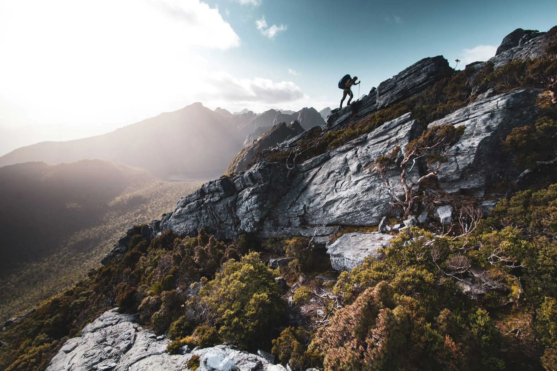
- I said it before, but it bears repeating, this track involves a lot of scrambling and borderline climbing. Don’t attempt this track unless you’re comfortable using your hands in addition to your feet.
- There are no fires permitted anywhere in the Western Arthurs.


Itinerary
The suggested Western Arthurs Traverse itinerary usually states that the traverse will take 9-11 days. If you are thinking of heading down Moraine K, the suggested itinerary is 7-9 days. That being said, I completed the track down Moraine K (bad weather forced us off) in five days (and I was not rushing—four wouldn’t have been too difficult—three would have been a push).
Here’s what’s “suggested” for the full traverse:
- Day 1: Scotts Peak Dam/Huon Campground to Junction Creek Campground 4.3 mi / 7 km
- Day 2: Junction Creek Campground to Lake Cygnus 4.54 mi / 7.3 km
- Day 3: Lake Cygnus to Lake Oberon 2.6 mi / 4.2 km
- Day 4: Lake Oberon to High Moor 2.6 mi / 4.3 km
- Day 5: High Moor to Haven Lake 2.36 mi / 3.8 km
- Day 6: Haven Lake to Promontory Lake 2.8 mi / 4.5 km
- Day 7: Promontory Lake to Lake Rosanne 5.9 mi / 9.5 km
- Day 8: Lake Rosanne to Cracroft Crossing 3.7 mi / 6 km
- Day 9: Cracroft Crossing to Junction Creek Campground ~9.3 mi / 15 km?
- Day 10: Junction Creek Campground to Scotts Peak Dam/Huon Campground 4.3 mi / 7 km
Here’s what’s “suggested” if you exit via Moraine K:
- Day 1: Scotts Peak Dam/Huon Campground to Junction Creek Campground 4.3 mi / 7 km
- Day 2: Junction Creek Campground to Lake Cygnus 4.54 mi / 7.3 km
- Day 3: Lake Cygnus to Lake Oberon 2.6 mi / 4.2 km
- Day 4: Lake Oberon to High Moor 2.6 mi / 4.3 km
- Day 5: High Moor to Haven Lake 2.36 mi / 3.8 km
- Day 6: Haven Lake to Junction Creek Campsite 9.07 mi / 14.6 km
- Day 7: Junction Creek Campsite to Scotts Peak Dam/Huon Campground 4.3 mi / 7 km
Yes, those distances are incredibly low for an entire day’s worth of hiking, and to the credit of the “suggested itinerary” people, the hiking isn’t straightforward once you make it up into the Arthurs. However, you can absolutely do this hike more quickly.
Here’s what I ended up doing (exit via Moraine K):
- Day 1: Scotts Peak Dam/Huon Campground to Junction Creek Campground 4.3 mi / 7 km
- Day 2: Junction Creek Campground to Lake Oberon 7.13 mi / 11.5 km
- Day 3: Lake Oberon to Haven Lake 4.96 mi / 8 km
- Day 4: Haven Lake to Junction Creek Campsite via Moraine K 9.07 mi / 14.6 km
- Day 5: Junction Creek Campsite to Scotts Peak Dam/Huon Campground 4.3 mi / 7 km


Western Arthurs Side Trips
Yes, the actual distance traveled each day may not be very high on the Western Arthurs Traverse, but there are plenty of opportunities to increase your daily mileage with some side trips. Some of the main detours (with their “suggested times”) include:
- Lake Fortuna (between Junction Creek and Lake Cygnus) – 800 m / 40 minutes round trip
- Mount Hayes (between Lake Cygnus and Lake Oberon) – 600 m / 40 minutes round trip
- Mount Sirus (between Lake Cygnus and Lake Oberon) – 800 m / 30 minutes round trip
- Mount Orion (between Lake Cygnus and Lake Oberon) – 800 m / 40 minutes round trip
- Mount Columba (between Lake Oberon and High Moor) – 500 m / 15 minutes round trip
- Mount Aldebaran (between High Moor and Haven Lake) – 1.37 mi (2.2 km) / 2-3 hours round trip
- Carina Peak (between Moraine K and Promontory Lake) – 0.87 mi (1.4 km) / 1-hour round trip
- Mount Canopus (between Moraine K and Promontory Lake) – 2 mi (3.2 km) / 3 hours round trip
- Lake Venus (between Promontory Lake and Lake Rosanne) – 600 m / 15 minutes round trip
- West Portal (between Promontory Lake and Lake Rosanne) – 800 m / 40 minutes round trip

What to Expect
As I’ve said twice before, the Western Arthurs Traverse is a serious hike worth every moment of your effort.
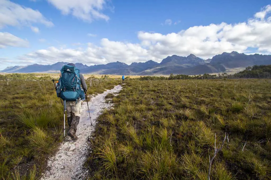
When I hiked the Arthurs, nearly the entire way from the trailhead until the base of the climb up Moraine A was mud – deep, sloppy, wet, leech-infested mud. I know you might be tempted to try to hop along the button grass and keep your feet out of the slop, but you’ll be a lot happier and a lot better off if you just accept that you’re going to be muddy and plunge through the middle (trust me on this one).
There’s a creek to rinse off in (aka walk through) at Junction Creek Campsite.


The trail isn’t necessarily difficult to find; it’s just slow going – especially once you ascend Moraine A and begin the actual traverse (and before, when you’re slogging through mud).
The way up Moraine A was still very muddy when I hiked up, so don’t think that you’re out of the terrible slog until you’re actually on the ridge (you’ll know when you’re there). Once you’re in the Arthurs, the trail isn’t difficult to follow, but there’s a lot of up and down (and much of it requires using your hands).
Also, don’t be surprised if you find yourself in more mud once on the ridge. It isn’t as bad as the plains below, but I found myself sinking into quite a few mud traps during the traverse (and once I even lost my shoe in one).


A lot of groups just go as far as Lake Oberon and then hike back out the same way (and possibly add a day trip further east from Lake Oberon), so if you’re discouraged by the number of people or the lack of camping at Lake Oberon, don’t despair.
The climb down to Lake Oberon is very steep, and the climb back up is equally steep (and there’s even a spot where you have to go up through the rocks and get to pop out a hole at the top – it’s awesome).


After passing High Moor, the trail reaches the Beggary Bumps. What is a “Beggary”? I have no idea (but according to the Google, it’s “a state of extreme poverty”). What are the Beggary Bumps? They’re challenging and awesome.
It’s basically a series of very steep ascents and descents, and along the way, you’ll reach a spot known as The Tilted Chasm.
If you have maps for the Western Arthurs, chances are this place will be labeled. It’s one of those places that is deserving of its own proper name and it’s one of those places that you get to and think to yourself, “No way this the trail, I must have made a wrong turn somewhere.” No, my friend, this is the trail, and it’s steep as fuck.


The Tilted Chasm and the Beggary Bumps are definitely the most challenging part of the trail (unless you count when I tried to take a shortcut heading down Moraine K and ended up lost for an hour).
That being said, you simply need to follow the route that will least likely kill you through this area, and you’ll be fine. In some trip reports, you may see mentions of using rope or doing some pack hauling through this area. This definitely isn’t 100% something you need to do (I didn’t), but it wouldn’t be crazy if you took some precautions.
Actually, I did end up throwing my pack down the trail at various points (and crossing my fingers, it didn’t roll off a ledge), so take what you will from that.


Providing details of the track probably won’t be very useful since if you need that level of detail to complete this traverse, you probably shouldn’t be out there in the first place.
Basically, know that it will be a muddy and challenging slog full of Type II Fun – and it will be worth every minute.
Good luck out there, friends!


I took Kappa Moraine (Moraine K) down from the Western Arthurs because of the weather but having spoken to reliable sources of information who continued beyond Moraine K to complete the entire traverse, I can tell you that the trail gets more overgrown and less maintained past Moraine K (as if it wasn’t ill-maintained before that point).
Western Arthurs Campsites
Camping is permitted anywhere along the Western Arthurs Traverse, but you would probably be best off sticking to the campsites (the ones up in the Arthurs have nice wooden platforms for you to pitch on).
- Huon Campground: this campground is at Scotts Peak Dam (aka the trailhead). (map)
- Junction Creek: a sheltered forest area with a couple of suitable areas for camping (one by the creek and another up the trail/hill a bit. It can be crowded since it’s technically on the Western Arthurs Traverse, the Port Davey Track, the South Coast Track, and the McKay Track. There is a pit toilet here. (map)
- Moraine A Camp: an overused couple of tent sites with reliable water at the base of Moraine A (where you begin the climb into the Western Arthurs). (map)
- Lake Cygnus: campsite near Lake Cygnus with four wooden platforms. There is a pit toilet here. (map)
- Lake Oberon: campsite near Lake Oberon with four platforms (we managed to squeeze three two-person tents on one. Camping off the platforms is possible, but it will probably be wet. There is a pit toilet here. (map)
- High Moor: an exposed area with wooden platforms and tent sites. Water can be unreliable. There is a pit toilet here. (map)
- Haven Lake: there are some campsites on the lake’s southern shore, and there are wooden platforms just east of the lake. There is a pit toilet here. (map)
- Lake Vesta: Some sheltered campsites are on the northeast side of the lake. (map)
- Lake Juno Outlet: after Lake Vesta, the trail descends steeply to cross the Lake Juno Outlet – there is a small campsite here. (map)
- Promontory Lake: there is a poorly sheltered camping area at the southeast corner of the lake. (map)
- Lake Rosanne: sheltered campsites can be found behind the sandy beach. (map)
- Cracroft Crossing: dry, flat campsites near the junction at the forest’s edge. (map)
Note: All locations marked above are given to offer a general location and are not necessarily exact.


Resources
- Parks Pass purchase
- Register for Western Arthurs
- Australia Bureau of Meteorology
- TASMAP Western Arthurs 1:50000 Topographic Map


I did this in 1988, I still think of it as one of the best hikes in the world. No campsites then of course, we squeezed a tent in any where we could amo gst the scrub, and we saw no one else at all. There was how ever a little taxi serving the trailhead a couple of times a week then. I do remember the muddy bit at the start, the snakes and the mosquitoes the size of horse flies. It rained. A lot and we had phenomenal thunderstorms some nights.
Sounds like a lot has changed – and a lot hasn’t :)
Just out of curiosity, what pack weights were you lugging around. Say for a Janurary hike. Cheers.
I can’t say for sure, but certainly had a baseweight under 20 lb / 9 kg.
This post is so informative. Just checking when did you go for this trail ? Will be that be even more difficult on August ? Your reply is much appreciated.
I did this trail in either February or March. I can give you exact dates when I’m off the Arizona Trail. I don’t know what snow levels would be like but there’s a chance it could be tougher in August.
Considering I’ve lived in Tasmania for 6 years and have done the PCT and AT in that time, I feel ashamed I’ve never got out there… Great trip account Mac.