Pacific Crest Trail Side Quests: Oregon
Pacific Crest Trail side quests are objectives PCT hikers can choose to accomplish during their hikes, but that don’t need to be completed to finish a PCT thru-hike.
Before beginning a Pacific Crest Trail hike – or perhaps any thru-hike – it’s common for would-be hikers to spend vast amounts of time meticulously researching, planning, and mulling over their coming adventure.
Many hours spent “planning” are simply a means of justifiably procrastinating anything else a PCT hiker could be doing before their hike, but I’m not here to judge. I’m here to do the opposite – to give you even more options when it comes to things to plan, research, and consider before setting out on a PCT hike.

Need to Know
Side quests are listed in geographical order from south to north. Some side quests are only applicable to Pacific Crest Trail hikers traveling in a particular direction (i.e., northbound or southbound).
I have assigned each of the Pacific Crest Trail side quests four ratings, an interest factor, difficulty factor, inconvenience factor, and a stupid factor.
All these are scored on a scale of 1 to 10 with a clarification of each scale below.
Also, the mileage used in all the below descriptions is based on data from FarOut. These mileages can change as the PCT is always being rerouted and (hopefully) improved – consider them approximate. If you aren’t already familiar with FarOut and you’re going to hike the PCT, you should invest in the app.
Interest Factor
Despite what you read in your overpriced guidebook, not all side quests are particularly interesting. This is an assessment of where the side quest falls on a scale of “not worth your time” to “absolutely should attempt”.
Difficulty Factor
It isn’t unreasonable to encounter a side quest that’s more challenging than any single stage of the Pacific Crest Trail. This is a rating of how difficult the side quest is to accomplish on a scale of “zero effort needed” to “significant physical or logistical effort needed”.
Inconvenience Factor
Sometimes a side quest might be interesting and easy, but it may be a huge hassle. This is a gauge of how inconvenient a side quest is on a scale of “will not alter your hike whatsoever” to “enormous pain in the ass”.
Stupid Factor
Some side quests have become part of Pacific Crest Trail lore and/or the PCT hiker culture that some may consider to be undeserving of such consideration. This metric rates how stupid a side quest is on a scale of “no at all” to “dumb af”.

The 10-Day Oregon Challenge
Interest: ⭐⭐⭐
Difficulty: ⚠️⚠️⚠️⚠️⚠️⚠️⚠️⚠️⚠️⚠️
Inconvenience: 😫😫😫😫😫
Stupid: 💩💩💩💩💩💩
Summary
The 10-day Oregon Challenge is precisely what it sounds like – hike the entirety of the Pacific Crest Trail through Oregon in ten days. According to FarOut, the PCT Oregon section is 457 miles (735 km) long (not including any alternates or stops in town).
To complete the 10-day Oregon Challenge, PCT hikers will need to average 45.7 mi / 73.55 km for ten days – not an easy feat, even in Oregon.
This is a feat that will (likely) be more suited to northbound thru-hikers instead of southbound thru-hikers as they will have been on the trail significantly longer by this point. That said, if you’re a southbounder looking to attempt this, don’t let me stop you.
I should note that I originally recall this being the two-week Oregon challenge, but I suppose it’s grown more aggressive in recent years.
Interest
This will be less interesting than it is interesting for most Pacific Crest Trail thru-hikers. Completing this side quest means you’ll likely miss much of what Oregon has on offer as you’ll be blazing through the state significantly quicker than most PCT thru-hikers. It will also make it difficult to attempt the other (more interesting) PCT Oregon side quests. Three interest points.
Difficulty
The 10-Day Oregon Challenge is one of the most difficult side quests of the Pacific Crest Trail. Not only do you need to hike huge days, but you need to maintain them for over a week.
The required daily average of 45.7 mi / 73.55 km will likely be more than most PCT hikers’ single longest day on the trail. According to last year’s Pacific Crest Trail hiker survey, the longest average day among thru-hikers who completed the trail was 37.2 mi / 59.87 km.
Maximum points for difficulty.
Inconvenience
Five points for inconvenience for the 10-Day Oregon Challenge because of the potential strain this will put on your body. It will be convenient in the sense you will spend less money on food and in town for Oregon and you’ll be that much closer to finishing your thru-hike. However, hiking this many miles this quickly could be a pain as well and your sleep and body will likely suffer. Five inconvenience points.
Stupid
Six stupid points for this. It’s not necessarily a stupid thing to do, but most hikers will likely consider this side quest to be quite stupid, indeed. That said, an awesomely not stupid feat should you complete this side quest.

The 24-Hour Challenge
Interest: ⭐⭐⭐
Difficulty: ⚠️⚠️⚠️⚠️⚠️
Inconvenience: 😫😫😫😫😫😫
Stupid: 💩💩💩💩💩💩💩
Summary
The 24-hour challenge is exactly what it sounds like – hike for 24 hours straight.
Pacific Crest Trail hikers can complete this challenge anywhere, but many choose Oregon because the state offers what is typically easier and less interesting walking than elsewhere on the PCT.
Interest
This will likely not be incredibly interesting to the majority of thru-hikers as staying up for 24 hours can do a lot of damage. Not only to your sleep schedule but also to your health and/or mental state. And that’s before you consider that this challenge involves hiking for 24 hours straight, not simply being awake for 24 hours.
Three stars for interest. Not something anyone should feel compelled to do.
Difficulty
Five points for the difficulty of a 24-hour hike. Most of the difficulty will likely come from either your body being so exhausted that it simply orders you to stop and/or sleep, or your brain being so tired that it simply decides to turn off and sleep. There will inevitably be a moment when you think “I’m so tired, why am I doing this?” and the will to sleep will eclipse the ambitions of earlier, not-as-sleepy you.
Inconvenience
Staying up and hiking for 24 hours straight isn’t in itself inconvenient but the aftermath is. Yes, you’ll likely cover a lot of distance, but you’ll also need to sleep afterward, potentially burning the entire following day. Planning a 24-hour day into town and immediately checking into a hotel and taking a zero would likely be the most effective way of completing this side quest. Six inconvenience points.
Stupid
The highest-rated stat of this side quest with a score of seven. Staying up for 24 hours to hike is pretty stupid, but then again, a lot of people would say the same thing about walking from Mexico to Canada. I know that things can get monotonous on the trail sometimes and can understand how mixing things up on a thru-hike can be appealing. Just be sure to make good decisions if you decide to take on this side quest. Don’t get yourself into a dangerous situation trying to stay up and hike for an entire day and night.

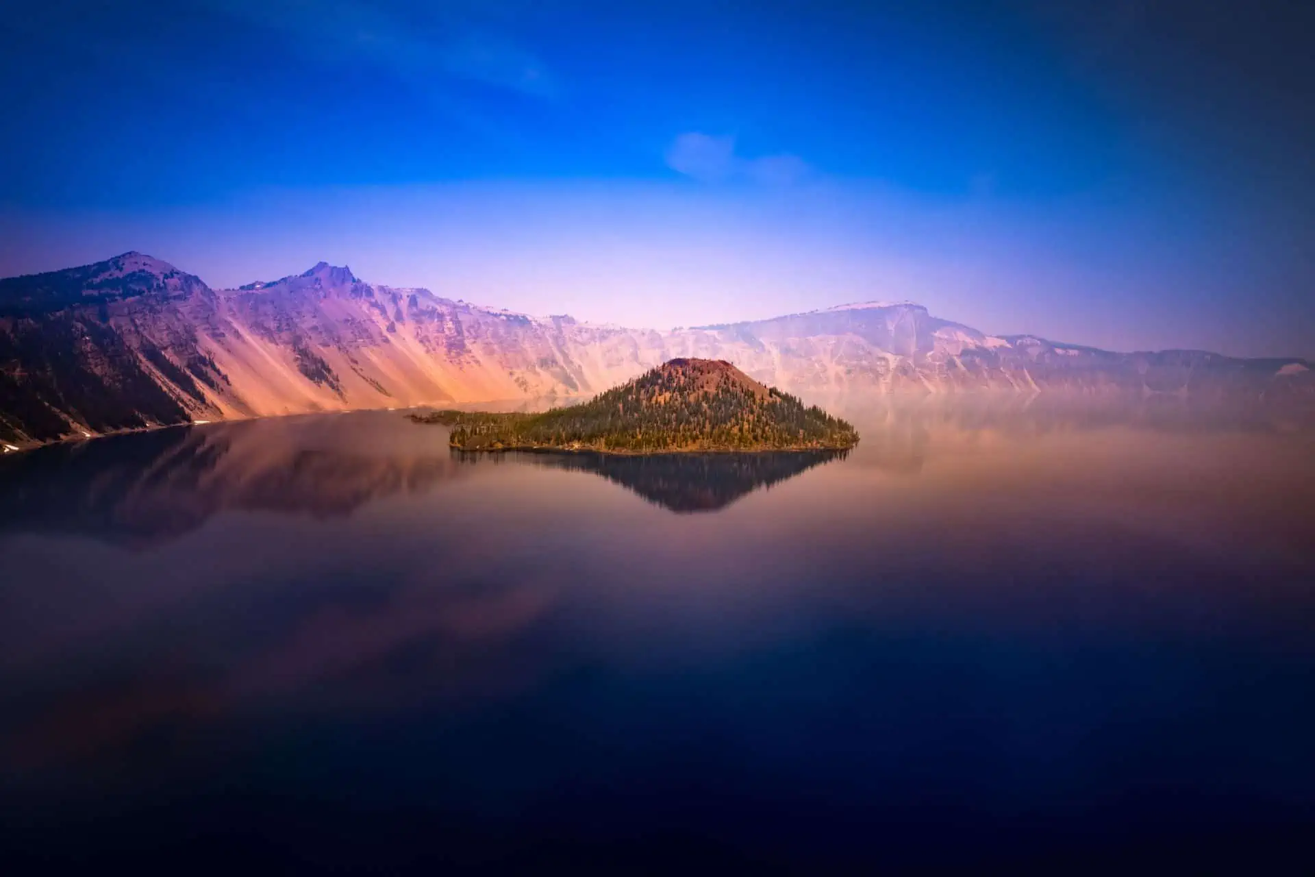
Crater Lake Rim Route
Interest: ⭐⭐⭐⭐⭐⭐⭐⭐⭐⭐
Difficulty: ⚠️⚠️
Inconvenience: 😫😫😫
Stupid: 💩
Summary
Crater Lake National Park, located in Southern Oregon, is the only national park in Oregon and is home to Crater Lake, the deepest lake in the United States (and ninth-deepest in the world).
The lake is the result of the caldera of Mount Mazama filling with water. There are no inlets or outlets from Crater Lake and the lake is filled exclusively via precipitation and snowmelt around the interior of the crater’s rim.
To reach the rim, PCT northbound PCT hikers depart the trail at mile 1824 via the Dutton Creek Trail and hike 11.5 mi / 18.5 km to rejoin the PCT at northbound mile 1840.2. Southbound mileages are 815 and 831.2 respectively.
Interest
If you don’t hike the Crater Lake Rim Route, you enter Crater Lake National Park, but you never actually see the park’s namesake. This is a maximum-interest, must-do Pacific Crest Trail side quest and is one that the majority of thru-hikers will undertake. Highly recommended.
Difficulty
The Crater Lake Rim Alternate is 4.7 mi / 7.6 km shorter than the Pacific Crest Trail, but it also has a bit more elevation gain. However, the route is a highly trafficked one within a national park which means it’s well-maintained. Two points for difficulty mostly because of all the day hikers and cars you’ll need to deal with at each of the road-accessible scenic lookouts.
Inconvenience
There is no camping along the Crater Lake Rim Alternate without a permit. Hiking the entirety of the Rim Alternate in a single day shouldn’t be an issue for most PCT hikers, but this could be complicated if you arrive late into the park and want to continue via the Rim Route.
As noted above, you’ll also need to deal with heaps of day hikers and vehicle traffic which bumps this from two points to three points of inconvenience.
Stupid
Minimal points here as there’s nothing stupid about hiking the Crater Lake Rim Alternate and completing this side quest. You should do this one. Just remember there’s no camping without a permit.

Hold the Axe
Interest: ⭐⭐⭐⭐⭐
Difficulty: ⚠️
Inconvenience: 😫😫
Stupid: 💩💩
Summary
A piece of Pacific Crest Trail trivia? Timberline Lodge – where the Pacific Crest Trail passes directly in front of – was used for the exterior opening shots for the movie, The Shining.
If you’re unfamiliar with The Shining, just know that an axe features prominently in the movie.
The front desk of Timberline Lodge has an axe you can ask to hold. Apparently, this is the axe from the movie, but I have been unable to verify this. If anyone has confirmation of this fact one way or the other, please let me know.
For those interested, check out Movies to Watch Before Hiking the Pacific Crest Trail.
Interest
Five points for interest as this is as much a Pacific Crest Trail easter egg as it is a side quest. It’s awesome Timberline Lodge has this available at reception for guests, visitors, and stinky backpackers. Even if you haven’t seen The Shining, I would recommend taking a photo with the axe and then watching the movie after your hike (or at night in your tent).
Difficulty
This is perhaps one of the easiest side quests of the Pacific Crest Trail. Simply enter Timberline Lodge, approach the front desk, and ask them if you can hold the axe. They’ll know what you’re talking about.
Inconvenience
Two points for inconvenience as you have to deviate ever so slightly from the Pacific Crest Trail to reach the front desk. You also have to talk to a person – scary, I know. But there are flushing toilets and you were probably going to go into Timberline Lodge for their buffet anyway. Don’t pretend like it’s that much of a hassle.
Stupid
Stupid? Maybe a little if you are for some reason opposed to The Shining or have a fear of axes? Two points.

Ramona Falls
Interest: ⭐⭐⭐⭐⭐
Difficulty: ⚠️
Inconvenience: 😫😫
Stupid: 💩
Summary
Ramona Falls is a 121 ft / 37 m waterfall on the upper Sandy River on the west side of Mount Hood – just north of Timberline Lodge on the Pacific Crest Trail.
It can be accessed from two points on the Pacific Crest Trail – 2 mi / 3.2 km apart. Hiking between these two points via the Ramona Falls Alternate is a total distance of 2.2 mi / 3.54 km.
Interest
There aren’t a ton of waterfalls on the Pacific Crest Trail, and with the low level of effort required to reach Ramona Falls, it should be of interest to many PCT hikers. Five points for interest. You’re not going to be kicking yourself if you miss the falls, but you also (probably) won’t be disappointed if you put in a small amount of extra effort to get there.
Difficulty
Reaching Ramona Falls from the Pacific Crest Trail is not difficult. The Ramona Falls Alternate is 2.2 mi / 3.54 km long versus the PCT’s 2 mi / 3.2 km. The alternate connects to the PCT on either side so there’s no need to backtrack. One difficulty point. Regardless of whether you’re hiking northbound or southbound, an extra 0.2 mi / 322 m of hiking should be trivial at this stage in the trail.
Inconvenience
You can hike to Ramona Falls from both sides which makes this a convenient alternate. If you want to miss as few miles of the official PCT as possible, you can also hike 0.4 mi / 643 m out and back (each way) to the falls from the PCT. Two inconvenience points.
Stupid
Nothing stupid about visiting Ramona Falls. It’s a nice trail to a nice waterfall. There are probably more reasons to visit than not to visit.

The Timberline Trail
Interest: ⭐⭐⭐⭐
Difficulty: ⚠️⚠️⚠️
Inconvenience: 😫😫😫
Stupid: 💩💩💩💩
Summary
The Timberline Trail is a 41.5 mi / 66.8 km circumnavigation of Mount Hood. Approximately 15.8 mi / 25.4 km of the Pacific Crest Trail already overlaps with the Timberline Trail on Mount Hood’s southwest side.
Interest
If you’re not planning on being in the area in the future or the Timberline Trail is something you’ve always been interested in, hiking it as part of a Pacific Crest Trail.
Four points for interest as most PCT hikers will likely not find this a compelling enough side quest to attempt. However, I wouldn’t be surprised to hear that plenty of hikers would dedicate the extra time and effort.
Difficulty
The Timberline Trail isn’t particularly difficult as far as terrain or elevation goes. A circumnavigation of the Timberline Trail is 41.5-mi / 66.8-km with approximately 10,875 ft / 3,315 m of elevation gain and loss.
Inconvenience
Hiking the entire Timberline Trail can be done in a single day. It’s a big day, but certainly not impossible. If you decide to hike to/from Timberline Lodge, you can even arrange to stay there before, after, or both – and even eat meals in the restaurant.
This means hiking the Timberline Trail will add some extra time to your hike, but not necessarily any extra strain typical of carrying supplemental food or gear. You could even slack pack the entire thing if you’re staying at Timberline and hike the entire trail with a minimal pack.
Stupid
It’s a little stupid to hike the Timberline Trail on a Pacific Crest Trail thru-hike. Many hikers are interested in not wasting time and would prefer that time “wasted” be in town resting and not hiking extra miles. That said, I am sure many hikers would find it interesting to be able to check off an additional trail as a part of their PCT thru-hike. Four stupid points. More not stupid than stupid.

Eagle Creek Alternate
Interest: ⭐⭐⭐⭐⭐⭐⭐⭐⭐
Difficulty: ⚠️⚠️
Inconvenience: 😫😫😫
Stupid: 💩💩
Summary
The Eagle Creek Alternate is at the northernmost end of Oregon, beginning or ending in Cascade Locks, Oregon depending on which way you’re hiking. The area was devastated by a fire in 2017 (started by fireworks being used during a burn ban), but it’s since reopened to the public.
Northbound hikers will depart the Pacific Crest Trail at Indian Springs Campground at mile 2130.3 and then rejoin the PCT in Cascade Locks at mile 2149.5. Southbound hikers will depart the PCT in Cascade Locks at PCT mile 505.7 and then rejoin the PCT at southbound mile 524.9.
This side quest is filled with swimming holes and waterfalls and is unlike any other place on the Pacific Crest Trail.
Interest
Another must-do side quest for Oregon. The Eagle Creek Alternate – not even officially part of the Pacific Crest Trail – is arguably the highlight of the PCT in Oregon. Ten stars. Waterfalls, a tunnel you walk through behind a waterfall, and swimming? Excellent.
Difficulty
The Eagle Creek Alternate is 14.5 mi / 23.4 km. The Pacific Crest Trail over this same distance is 19.2 mi / 30.9 km. The extra point of difficulty for the Eagle Creek Alternate comes from the fact you’ll need to deal with day hikers and you’ll be both tempted to swim and take photos everywhere.
Inconvenience
The most inconvenient part of the Eagle Creek Alternate is you’ll spend 2.2 mi / 3.5 km walking next to a highway. Fortunately, there’s a train next to the highway so you’re not actually roadwalking, but it’s about as close as you can get.
If you don’t care about these miles, try making friends with some day hikers and getting a hitch into Cascade Locks from the trailhead.
Stupid
Two stupid points instead of one for the Eagle Creek Alternate because you’ll have to deal with day hikers and you’ll be faced with a walk next to a road once you reach the trailhead.

Pacific Crest Trail Days
Interest: ⭐⭐⭐⭐⭐⭐⭐⭐
Difficulty: ⚠️
Inconvenience: 😫😫😫😫😫😫
Stupid: 💩💩💩
Summary
Pacific Crest Trail Days (PCT Days) is an annual event held each August in Cascade Locks, Oregon – at the Oregon-Washington Border on the PCT. Imagine a small country fair where everyone camps together on an island across from the fairgrounds.
Interest
Eight points for Pacific Crest Trail Days. Certainly not something you have to attend as a PCT hiker, but also something that may be worth taking s bit of extra time to plan to attend. It’s like going into town but everyone understands exactly what you’re doing and/or like you (malnourished and stinky). It’s a place you can feel incredibly special and not special at the same time.
Difficulty
One point for the difficulty of attending Pacific Crest Trail Days. You simply need to be existing at a point on the trail to attend. Difficult? No. Inconvenient? Possible.
Inconvenience
Six points of inconvenience for PCT Days. It’s scheduled at a time and place (the end of August in Cascade Locks) to fit with the schedule of both northbound and southbound PCT hikers, but it’s by no means some magical date when everyone happens to be in Cascade Locks, Oregon.
Many hikers will have to hitch, use public transportation, or rent cars to reach Pacific Crest Trail Days, and in addition to the time they spend at PCT Days, they’ll also need to spend time traveling to and from the event.
Stupid
Three points for stupid because many hikers feel compelled to attend the event even at great cost to themselves or huge inconvenience. You by no means have to attend PCT Days and if it’s going to be a huge inconvenience or financial burden for you to attend, you should simply keep hiking.

Wrap Up
It’s easy to get excited when planning a Pacific Crest Trail hike and imagine you’re going to do ALL THE THINGS. However, the reality is often different from the idealistic plans you make beforehand.
Oftentimes, you’ll be exhausted from hiking, and the thought of venturing off the PCT or adding any complications to your thru-hike will seem like madness. That said, other times you may be inspired to put in some extra effort and get some bonus XP.
Have a Pacific Crest Trail Oregon side quest you believe is worthy of making this list? Know of an Oregon side quest that more PCT hikers should be taking advantage of?
Leave a comment below or get in touch!
Affiliate Disclosure: This page may contain affiliate links, which means I may receive small commissions for purchases made via these links at no additional cost to you. This helps to pay the bills and keep the site up and running. Thank you for your support!


I have to note that the survey for the PCT just sends you into an endless loop of Captcha questions. The Captcha for posting is much easier to deal with. ?!?
Which link are you referring to here?
Hey Mac. I gotta write to defend Oregon as I live here and honestly it’s got excellent stretches of scenery (Crater, Thielsen, Diamond Peak, Jefferson Park, Hood, etc.) that is best appreciated when hiking while the trail is snow covered. It’s awesome for late spring when it’s warm and snowed in and the skeets are way less. It’s certainly better than S. Washington in all respects which is pretty blah till Goat Rocks. Just my 2 cents.
It’s too bad no PCT thru-hiker will see it in late spring during their thru-hikes (unless they do some unusual flip-flopping).
Next time I get up there I’ll be sure to make it up late spring!