Guide to HRP Huts, Shelters, and Lodging (Part 1: Hendaye to Lescun)
One of the things I found most frustrating when planning my Pyrenees High Route (HRP) hike was the lack of readily accessible information regarding the lodging options available along the route. This primarily applied to the huts and shelters along the route in the backcountry, but it also extended to the hotels, hostels, and refugios located in towns along the way.
I’ll publish a separate town guide (to the best of my ability), so I won’t go into detail here regarding food and resupply options. Instead, I’ll try to keep this guide focused on places where you can take shelter from the elements during your hike (and what service, if any, each of these places provides).
As HRP hikers quickly realize, not all shelters are created equally, and just because the map tells you there’s a shelter ahead, it may not necessarily be a shelter that you’ll want to stay in (e.g., it might have a floor covered in animal poop) or it may not be a shelter that’s safely habitable (e.g., the roof may be caving in).
The first part of this comprehensive HRP hut, shelter, and lodging guide will cover those found between the western terminus in Handaye, France, and eastward to Lescun, France.

Notes on the Guide
- I list the shelters here from west to east, beginning at the Atlantic Ocean in Hendaye, France, and ending at the Mediterranean Sea in Banyuls-sur-Mer, France.
- The mile markers assigned to each shelter are based on my own HRP hike’s GPS track, and the distances may vary slightly (or wildly) depending on which alternate routes, spur trails, or detours you take on your hike.
- Based on information I’ve heard from others, there’s a chance shelters will be either closed or open, depending on the time of year. You should not count on unstaffed shelters being available at all times, as they may be locked and/or in use depending on the time of year (some are private and/or reserved for shepherds). Alternatively, just because a shelter was locked or closed for me, it doesn’t necessarily mean it will be when you pass by.
- I hiked the HRP from September 13 to October 13.
- “Guarded” refugios are the ones that have staff, meals, bunks, and toilets.
- Outside of the staffed season, these refugios will all have a small sheltered area available for use. This is oftentimes known as the winter shelter.
- It is wise to carry cash with you in the Pyrenees, as not all the refugios will accept credit cards.
- I didn’t stay at all the accommodations listed below, but I’ve made note of the ones I did stay (or eat) at. All photos (except those noted as from Google Street View) are from my thru-hike.
Camping Alturan
- Mile: 0
- Rating: N/A
- Description: Developed campground in a city
- Location: 43.37299, -1.76264 in Hendaye, France
- Elevation: Sea level
- Evaluation: N/A
- Cost: €40 for up to two people
- Phone: +33 559 200 455
- Website: Camping Alturan
- Open: June 30 to September 30
- Reception Hours: 9:00 to 13:00 and 15:00 to 20:00
- Notes: I didn’t stay here or go past this place in town, but according to the website, it appears to be a viable camping option for those seeking a budget-friendly spot to stay in town and get an early start the next day.

Pilotalekugaña/La Rhune Shelter
- Mile: 13.75 (22.13 km)
- Rating: ⭐
- Description: Basic stone shelter
- Location: 43.30688, -1.63014
- Elevation: 2,800 ft / 853 m
- Evaluation: A pretty crappy stone structure with a damp, muddy floor filled with animal poop – would not stay.
- Cost: Free
- Notes: I did not find a name for this shelter, but it’s located next to the peak Pilotalekugaña, just next to La Rhune. It’s at the top of a big climb.


Kondendiagako Lepoa
- Mile: 13.75 (22.13 km)
- Rating: ⭐⭐⭐
- Description: Basic wooden shelter
- Location: 43.29407, -1.62778
- Elevation: 1,041 ft / 317 m
- Evaluation: A nice-looking shelter with a covered outdoor area
- Cost: Free
- Notes: I didn’t go into this shelter because I was rushing to get to the next town before the restaurant closed (it was closed despite Google Maps saying it would be open), but it looked nice. Not 100% sure if it was unlocked, but the covered outdoor space would have been a good spot to sleep regardless.

Lizuniaga
- Mile: 16.2 (26.1 km)
- Rating: N/A
- Description: Restaurant and hotel
- Location: 43.28258, -1.63218
- Elevation: 737 ft / 225 m
- Evaluation: I didn’t stay here, and it looked closed when I passed (after sunset). There’s no English language website, and booking is available via Booking.com
- Phone: +34 948 63 10 31
- Website: https://lizuniaga.site/
- Cost: Starting at €84
- Notes: They also have a restaurant that’s open Friday (11-15:00), Saturday (9-18:00), and Sunday (9-17:00). There’s also a vending machine outside that only accepts coins (so bring some coins if you want a soda when you pass).
- Book Here

Maison Hordago Bar Restaurant et Chambres d’hôtes
- Mile: 19.45 (31.3 km)
- Rating: N/A
- Description: Restaurant and hotel in Sare, France
- Location: 43.26099, -1.61939
- Elevation: 1,439 ft / 439 m
- Evaluation: Looks nice – I would have stayed if the reception was still open when I passed.
- Phone: +33 7 86 69 41 14
- Website: https://www.chambresdhotes-hordago.com/
- Cost: €85
- Notes: I passed this place after dark, and it appeared to be all closed up for the evening. If you want to stay here, I suggest calling or arriving early. There are public bathrooms and a parking area (which had van lifers) just south of the hotel.
- Book Here

Cabane d’Usategieta
- Mile: 20 (32 km)
- Rating: ⭐⭐
- Description: Basic stone shelter
- Location: 43.25580, -1.61493
- Elevation: 1,535 ft / 468 m
- Evaluation: Decent shelter – the interior isn’t super nice (no sleeping platform), but it would be welcome in poor weather. There was a counter, some shelves, and three chairs inside when I passed.
- Cost: Free
- Notes: I got here at night and opted to sleep on the picnic table outside instead of on the floor of the shelter. In the morning, two men (hikers?) came by as I was packing up. It’s not exactly on the trail, but it’s very nearby. There are nice privies located a bit west of here before leaving the road (hit them on your way if you’re hiking eastbound).


A short video of the inside of the shelter (at night)
Casa Rural Gontxea
- Mile: 32.5 (52.3 km)
- Rating: N/A
- Description: Hotel in Arizkun, Spain
- Location: 43.17431, -1.48398
- Elevation: 909 ft / 277 m
- Evaluation: Looks like a decent hotel. They have an English-language version of their website.
- Phone: +34 948 453 433
- Website: https://www.gontxea.com/
- Cost: €68
- Notes: I didn’t stay here or pass by to check it out.
- Book Here

Centre Auberge Erreka Gorri
- Mile: 40.9 (65.8 km)
- Rating: N/A
- Description: Hostel in Aldudes, France
- Location: 43.09489, -1.42530
- Elevation: 1,243 ft / 379 m
- Evaluation: It’s a hostel, I didn’t stay here or pass by to check it out.
- Phone: +33 6 72 93 84 57
- Website: https://sejours.pep64.org/destinations/aldudes/
- Cost: Unknown
- Notes: I didn’t stay here, but I did stop at a nearby restaurant to eat and charge my power bank for a bit. The website isn’t great in terms of information.

Refugio de Trona
- Mile: 40.9 (65.8 km)
- Rating: ⭐⭐⭐⭐⭐
- Description: Nice unstaffed shelter with electricity (no charging, only lights), a table, benches, and windows
- Location: 43.02616, -1.35251
- Elevation: 3,970 ft / 1,210 m
- Evaluation: One of the nicest shelters I stayed at for the entirety of the hike (and the only one I stayed in that had electricity)
- Cost: Free
- Notes: On maps, this may be listed as “Refugio De Cazadores,” which simply translates to “hunters’ refugio.” There is plenty of space outside for camping as well. This shelter is not on the trail, and requires a very slight detour; it’s worth it.


Izandorre
- Mile: 46 (74 km)
- Rating: ⭐⭐⭐
- Description: Nice, small, unstaffed shelter
- Location: 43.03731, -1.28862
- Elevation: 4,312 ft / 1,314 m
- Evaluation: Nice shelter with elevated platforms and a window
- Cost: Free
- Notes: This shelter is located on a section of the trail that overlaps with the Camino Francês (French Way) of the Camino de Santiago. There is a high likelihood that this shelter will be very crowded, regardless of the season. For this reason, I would not recommend staying here.


Azpegiko Aterpea / Refugio de Azpegui
- Mile: 49.8 (80.15 km)
- Rating: N/A
- Description: An unstaffed, road-accessible, nicely built shelter
- Location: 43.03204, -1.22786
- Elevation: 3,203 ft / 976 m
- Evaluation: Nice-looking shelter
- Cost: Free
- Notes: This shelter is located 0.3 mi / 500 m south of the HRP. It’s road-accessible, which means your chances of having company are higher. I didn’t visit this shelter, but the reviews on Google Maps lead me to believe it is open.

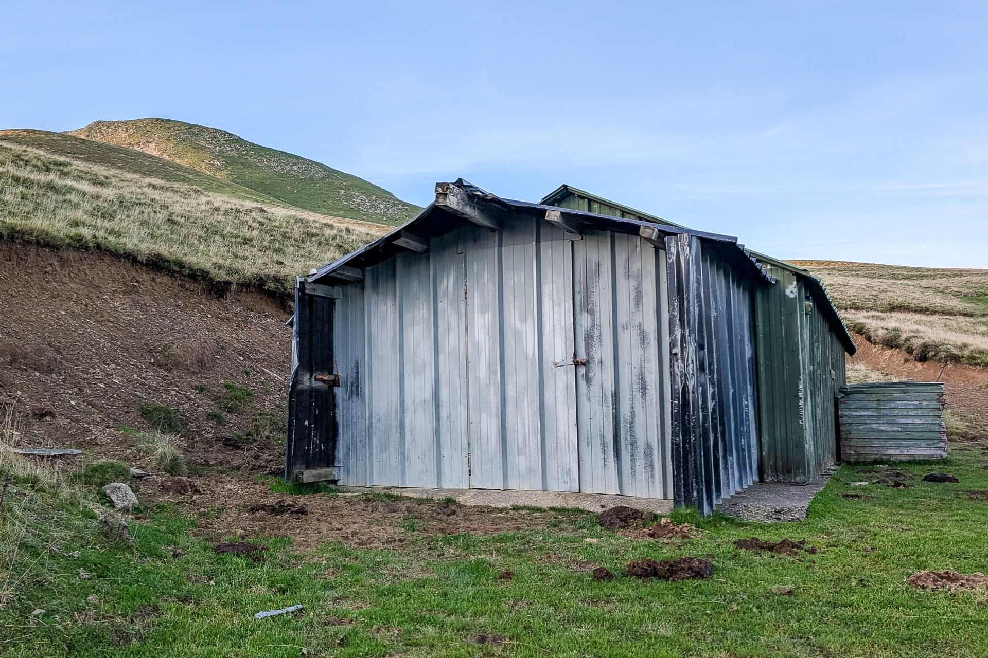
Cabane d’Orgambide / Organbideko Etxola
- Mile: 51.1 (82.2 km)
- Rating: N/A
- Description: A metal, road-accessible shelter
- Location: 43.04990, -1.21135
- Elevation: 3,242 ft / 988 m
- Evaluation: Nice-looking shelter, but it was locked when I passed on September 15
- Cost: Free
- Notes: It’s a nice-looking shelter, but since it was locked, I’m not sure it can be relied upon. I’m not sure if it was locked due to the time of year or if I was just unlucky on the day I passed it. I found a photo of the interior here.


Errozate Cabin
- Mile: 54.3 (87.4 km)
- Rating: ⭐
- Description: A crappy, mud-filled cinderblock shelter
- Location: 43.03738, -1.17313
- Elevation: 3,465 ft / 1,056 m
- Evaluation: It looks a lot nicer from the road above than it is inside. If the weather was raging, this might be a welcome reprieve, but I wouldn’t want to have to sleep in here.
- Cost: Free
- Notes: Next to a road.


Chalet Pedro
- Mile: 61.5 (99 km)
- Rating: N/A
- Description: A restaurant with a few lodging options
- Location: 43.03699, -1.07554
- Elevation: 3,269 ft / 996 m
- Evaluation: It appears this place is primarily suited for larger groups rather than solo travelers, but the website offers a variety of accommodation options. Perhaps worth checking out if you’re looking for somewhere nicer to stay. They may require a two-night minimum stay.
- Phone: +33 5 59 28 55 98
- Website: https://www.chaletpedro.com/
- Cost: Unknown
- Notes: I didn’t eat or stay here, but according to their website, they’re open year-round.

Refuge Aterbea
- Mile: 61.9 (99.6 km)
- Rating: N/A
- Description: A building with a spigot, bathrooms, and showers
- Location: 43.04156, -1.07471
- Elevation: 3,734 ft / 1,138 m
- Evaluation: These are nice toilets and showers in what I believe used to be a basic refugio. There’s nowhere to sleep as the larger part of the building is inaccessible (from what I saw), but it could provide shelter in a storm.
- Cost: Free camping across the street
- Notes: Next to a road. Across the street, there is an area where you can camp for free (provided you don’t have a vehicle) between 6:00 PM and 9:00 AM.


Les Chalets d’Iraty
- Mile: 65.1 (104.8 km)
- Rating: N/A
- Description: Accommodation with campsites, hotel rooms, and chalets
- Location: 43.03669, -1.03489
- Elevation: 4,341 ft / 1,323 m
- Evaluation: N/A
- Phone: +33 5 59 28 51 29
- Website: https://chalets-iraty.com/
- Cost: Camping from €3.50
- Notes: It appears that rooms and chalets must be booked on a weekly basis (although I’m unsure). There’s also a small store here where you can get some resupply, also located on the GR10.


Unnamed Shelter
- Mile: 68.9 (110.9 km)
- Rating: ⭐
- Description: A crappy shelter
- Location: 43.00968, -1.02832
- Elevation: 4,726 ft / 1,440 m
- Evaluation: A shelter that’s falling apart; I would not recommend staying in it. If you push a bit farther, you get to a better shelter.
- Cost: Free
- Notes: I couldn’t find a name for this shelter, but it appears on some maps.

Abri Tharta / Cabane de Zazpigain
- Mile: 69.6 (111.9 km)
- Rating: ⭐⭐⭐
- Description: A metal and wooden shelter with windows.
- Location: 43.00450, -1.02047
- Elevation: 4,730 ft / 1,442 m
- Evaluation: A welcome shelter that’s relatively clean. It has counters, benches (which can be combined to form a sleeping platform), and two rooms.
- Cost: Free
- Notes: Upon entering the first door, you find yourself in a small entryway. You then need to open a second door to access the larger part of the shelter. When I stayed here, there were horses outside all night with clanging bells around their necks.


Refugio de Belagua
- Mile: 82.5 (132.8 km)
- Rating: ⭐⭐⭐⭐⭐
- Description: A staffed refugio with power, charging, beds, camping, and food
- Location: 42.94511, -0.83468
- Elevation: 4,676 ft / 1,425 ft
- Evaluation: Maybe my favorite staffed refugio of the entire trip. Friendly staff, good food, beautiful building, outlets for charging, and flushing toilets.
- Phone: +34 6 23 10 73 17
- Website: https://refugiobelagua.es/en/
- Cost: €16/night or €36 with 1/2 board
- Notes: Open year-round (except December 24 and 25). They allow you to camp outside (free of charge) in a covered area under the deck if you don’t want a bed (this is what I did, and I found it quite comfortable). It’s also road-accessible.


Hébergement Pic d’Anie
- Mile: 94.9 mi (152.7 km)
- Rating: N/A
- Description: A bed and breakfast in the town of Lescun, France
- Location: 42.93379, -0.63519
- Elevation: 2,936 ft / 895 m
- Evaluation: It looks to be a nice bed and breakfast. I didn’t stay here, but it was busy out front when I passed.
- Phone: +33 5 59 34 71 54
- Website: https://nouveau.hebergement-picdanie.fr/
- Cost: Starting at €18/night
- Notes: You can either stay here for a low rate (starting at €18) or opt for a bed and breakfast option with various meal plans available. The website spells everything out nicely. Also located on the GR10.

Camping du Lauzart
- Mile: 95.6 mi (153.8 km)
- Rating: N/A
- Description: A campground located just south of the center of Lescun, France
- Location: 42.92784, -0.64221
- Elevation: 2,807 ft / 856 m
- Evaluation: It appears to be a decent option for the most affordable place to stay in Lescun. It’s a little far from the town, so you won’t want to be walking back and forth, but they (apparently) have snack pizza there, so what more could you ask for? I didn’t stay here.
- Phone: +33 5 59 34 51 77
- Website: https://www.camping-gite-lescun-pyrenees.com/
- Cost: Starting at €11/night
- Notes: Also located on the GR10.

Additional Resources
- https://www.refuges.info/ – A crowdsourced French website with details of shelters across Europe
- https://www.pyrenees-refuges.com/ – A French website with more information of shelters in the Pyrenees
- https://www.gites-refuges.com/ – A French website listing shelters along the HRP
- https://www.feec.cat/ – A Catalonion website covering some shelters in the eastern part of the HRP