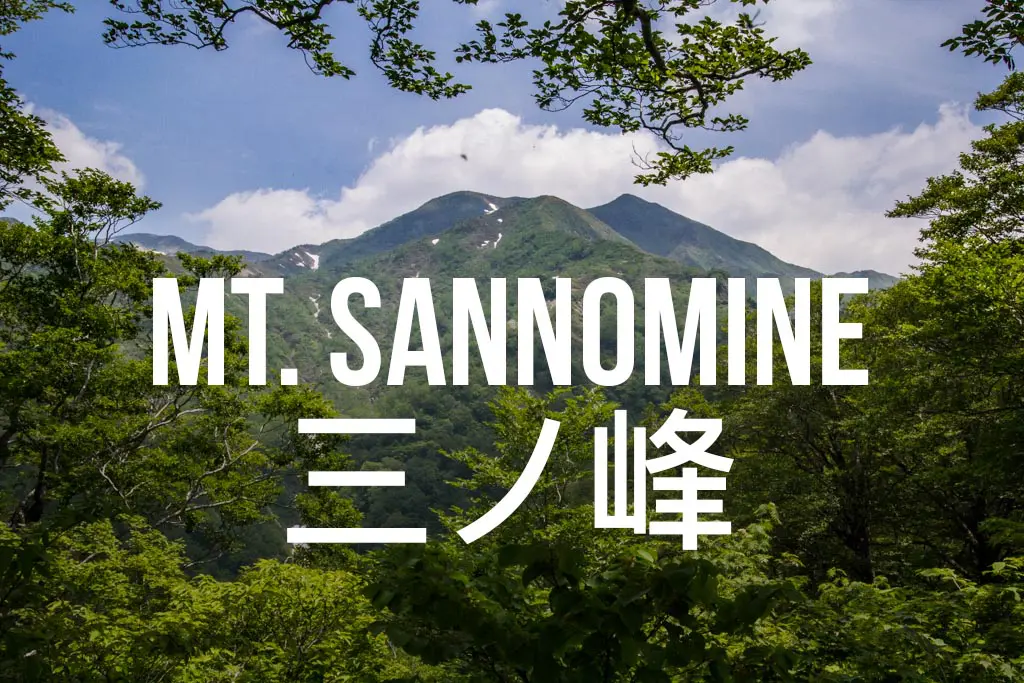
Hiking Mount Sannomine (三ノ峰) in Japan
Mount Sannomine (三ノ峰, Sannomine) sits on the border of Fukui (福井), Gifu (岐阜), and Ishikawa (石川) in Japan’s Ryōhaku Mountains (両白山地).
The trailhead is not easy to get to, and if you don’t have your own transportation, then you’re out of luck unless you want to hire a very expensive cab (hitching would be difficult).
You can hike Mount Sannomine as a day hike, traverse north to Mount Bessan (also possible as a day hike), or continue even farther north towards Mount Haku (白山, Haku-san) and into Ishikawa.
Basic Info
- Name: Mount Sannomine
- Japanese name: 三ノ峰 (Sannomine)
- Location: Ono, Fukui (福井県大野市)
- Summit elevation: 7,103 ft / 2,165 m
- Elevation change: 4,856 ft / 1,480 m
- Round-trip distance from trailhead: 8.01 mi / 12.89 km
- Round-trip time from trailhead*: 5:52 moving time / 7:58 total time
- Difficulty: Moderate
- Water on trail: No
- Trailhead facilities: Free parking, bathrooms, campground
- Nihon Hyaku-meizan: No
*Note: The round-trip time listed above is based on my own experience. Please remember that your time may vary greatly.
Getting to Mount Sannomine
- Region: Hokuriku (北陸地方)
- Accessible via public transportation: No
- Trailhead parking: Yes
- Trailhead coordinates: 36.060195, 136.714993
- Summit coordinates: 36.089093, 136.754430</li>
BY CAR: The trail up Mount Sannomine begins in Koike Park in Ono, Fukui. To get here you will need to follow a narrow and winding road up through a valley from near the base of Mount Arashima.
BY TRAIN OR BUS: Sorry, you definitely need your own transportation to get here (the trailhead is very remote).
The Hike
The hike up Mount Sannomine begins at one of two parking lots, but both end up following the same forest road up to the trailhead so you don’t have to worry about where you park (and both have bathrooms to steal toilet paper from).

Starting out, the forest road follows the river before finally coming to the true trailhead a bit farther up the valley (marked with a large sign and map of the mountain).
TIP: Make sure you have the kanji (that means Japanese character) for Mount Sannomine (三ノ峰) written down or saved because most of the signs for this hike are in Japanese only.

A step-filled trail (hooray!) leads up and away from the forest road to begin what will be about an hour and a half hike up the mountain to your first waypoint atop a ridge overlooking the valley you drove up to get here.
From here a trail to elsewhere (that I have not investigated) splits off to the left, and the route up Sannomine continues to the right. Continue the climb as your destination comes into view and you climb above the forested hillside.
There are few places to break along the path (including one viewpoint with a sign identifying the surrounding mountains – in Japanese), so take advantage of them if you need a rest, snack, or beer. The trail offers nice views all the way up from the first ridge if the clouds (and bugs) are cooperating.

About an hour from the summit, the trail reaches a bench – a good place to take a last break before making your final push. Beyond, the trail follows a set of steep and narrow switchbacks climbing up to the shelter just below the summit.
The shelter has room for around ten people to sleep comfortably (but you could certainly squeeze more). A pit toilet (separated from the sleeping area by a small entrance room) has also been installed (although it smelled awful when I made my trip up – and the entire place was filled with flies).
Camping is probably a more attractive option if you plan on staying the night up here.

The Summit
The summit of Mount Sannomine is a small clearing with a not-so-well-taken-care-of summit marker (the side that reads “Mount Sannomine” is the one facing you when you arrive).
If the weather cooperates you will be able to see Mount Bessan to the north, and Mount Haku beyond.
Head back the way you came if Sannomine is your destination, or follow the trail north from the summit towards Mount Bessan in the distance.

Map of Mount Sannomine
The following was my GPS’s route on my hike up Mount Sannomine.
I have no guarantee that this route is correct, nor that it can be accurately relied upon for backcountry navigation. It should serve only as a general guideline for what the trail is expected to look like.
I have also included screenshots of the recorded elevation profile and my hike’s overall stats in case any of you find any of it useful (imperial on the left, metric on the right).


Conclusion
Mount Sannomine is worth climbing if you have your own transportation.
The trailhead can be the starting point for many other longer hikes to other peaks as well (although you may need someone to bring you back around to your car if you don’t want to retrace your steps).
If you want something even more challenging, I would recommend getting to the trailhead early (like at sunrise) and heading up with the goal of tagging Mount Bessan (beyond Mount Sannomine) and heading back before sunset.
Have any questions about Mount Sannomine? Want another post about another one of Japan’s mountains? Have a suggestion to improve this information?
Leave a comment and let me know!