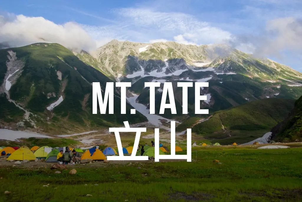
Hiking Tateyama (立山) in Japan
- Name: Mount Tate
- Japanese name: 立山 (Tateyama)
- Location: Tateyama, Toyama (富山県立山町)
- Summit elevation: 9,892 ft / 3,015 m
- Elevation change: 2,017 ft / 615 m
- Round-trip distance from trailhead: 3.5 mi / 5.6 km
- Round-trip time from trailhead*: 3 hours 30 minutes (from Murodō)
- Difficulty: Moderate
- Water on trail: No
- Trailhead facilities: Parking, bathroom, campground, lodge, drinks, food
- Nihon Hyaku-meizan: Yes
- LIVE WEBCAM
Mount Tate (Tateyama), one of Japan’s three holy mountains (三霊山, Sanreizan) along with Mount Fuji (富士山, Fujisan) and Mount Haku (白山, Hakusan), and one of Japan’s 100 Famous Mountains, is located in the northern half of Japan’s Kita Alps (北アルプス) and is one of the most accessible peaks in the area.
The hike can be easily completed in a day, and the trailhead is easily accessible. However, if you find yourself here in good weather during the middle of summer (or, God forbid, on a holiday), then prepare yourself for crowds.
*Note: The round-trip time listed above is based on my own experience. Please remember that your time may vary greatly.

Getting to Mount Tate
Note: The information below outlines the steps to reach Tateyama Station (立山駅). You can begin the hike from here, but the majority of trekkers opt to take the Tateyama Kurobe Alpine Route (立山黒部アルペンルート) up to start their hikes from Murodō (室堂). The round-trip cost of the Alpine Route from Tateyama Station to Murodō is ¥4,310 (English website).
- Region: Kita Alps (北アルプス)
- Accessible via public transportation: Yes
- Trailhead parking: Yes
- Trailhead coordinates: 36.583232, 137.445165 (Tateyama Station) or 36.577296, 137.595524 (Murodō Station)
- Summit coordinates: 36.573181, 137.617791
By Car
If you don’t want to hike over from Mount Tsurugi (剱岳), then just drive to Tateyama Station on the Toyama Chihō Railway (富山地方鉄道). There is a free parking lot down the hill from the station (36.585820, 137.448498).
By Train
By train, you need to arrive at Tateyama Station via the Toyama Chihō Railway, which can be reached via a transfer at Toyama Station (富山駅). From here, you can begin your hike or take the Alpine Route to Murodō (accessible upstairs from the train platforms). Check Hyperdia for train schedules.

The Hike
Tateyama is the name of the entire summit area surrounding Murodō, and it is composed of numerous peaks, the most prominent of which is Onanji (大汝山).
To get here from Murodō, follow the signs (and paved path) up to the Ichinokoshi Hut (一ノ越山荘). You may need to cross some snowfields on your way, but the trails are meticulously groomed and cut out from the mountainside by Tateyama staff (there’s a lot of hand-holding up here).
From here, the real trail starts as it quickly gains elevation, zigzagging upward through a maze of boulders and day hikers. It takes about a few minutes to reach Oyama (雄山), the summit area just before Onanji.

The Summit
Oyama is a markedly sad place.
It’s not nearly as large (or as sad) as the summit of Mount Ibuki, but it’s a good size and can comfortably hold a few dozen hikers.
A store full of overpriced mountain memorabilia and a shrine that costs ¥500 to visit are the two main attractions, wholeheartedly endorsed by many Japanese hikers.

Continue north along the ridge for approximately twenty more minutes to reach Onanji while (hopefully) enjoying the surrounding peaks and views, all the way to Mount Fuji in good conditions.
From the top, you can either retrace your steps back to Murodō, continue straight and hang a left at the next trail junction to reach Murodō via Raicho-daira (雷鳥平), or continue your adventure north towards Mount Tsurugi.
Map of Tateyama
The following was the route my GPS recorded during my hike up Mount Tate (this route begins at the Murodō campground and ends at Murodō terminal; however, it omits the last section up to Onanji due to technical difficulties).
I have no guarantee that this route is correct, nor that it can be accurately relied upon for backcountry navigation. It should serve only as a general guideline for what the trail is expected to look like.
I have also included screenshots of the recorded elevation profile and my hike’s overall statistics in case any of you find them useful (imperial units pictured).


Conclusion
The area surrounding Tateyama is easily one of my favorites in Japan because of the numerous options available from a single location.
From Murodō, you have the option to climb not only Tateyama but many other mountains, many of which can be done as day hikes (or you can traverse north to Tsurugidake or south to the Yarigadake ridgeline).
Of the three holy Japanese mountains, the peak is probably my second favorite (Hakusan being first and Fuji last). Still, as I mentioned earlier, the surrounding area is one of the best I’ve visited in Japan. It’s a mountain playground just waiting to be explored.
Have any questions about Tateyama? Want another post about another one of Japan’s mountains? Do you have a suggestion to improve this information?
Leave a comment and let me know!


Hii!
Thank you for your post!! So helpful and interesting.
I have a few questions.. hopefully you’ll be able to answer me
I’m in Kanazawa now and I’m planning to hike Tateyama this week. Since I have my luggage in Kanazawa, I’m planning to go to the top of Tateyama and come back (do a round trip), but I’m having a hard time with the time schedule.
The bus stops at Murodo at 11:10 am. I think I’ll get to the top at around 1 pm, and then the bus leaves from Murodo at 3:30 pm back to Tateyama Station.
Do you think it’s enough time to enjoy the view and come back to Murodo? I guess the way back takes less time..
You said that from Murodo is possible to hike to other peaks, but I guess that’s only if you spend the night there, right?
Thank you so much !!
In the nicest way possible, this sounds like a question only you can answer. It all depends on how quickly you move and how you define enjoying the view.
Very nice write ups. Looks like a very do-able hike to bag a peak for average hiker. If we are to do this in April though, I assume that the trail will be snow-covered?
I would say that in most years you can 100% expect snow in April.
Can you post everything in metric? Thanks.
I do post everything in metric. You’re welcome.
Hi Mac, do you think this climb is possible in April?
There will (likely) be a lot of snow in April. Possible? Sure. Experience and equipment required? Most likely.
Hi mac, do you think this hike is possible in December? I have not done one in snow before, and I’m wondering if this is a good place to try it. Thanks!
I guess it really depends on how much snow there is at that point in the year. I am sure it’s totally doable in some years, but if there’s an early snowfall it might be tricky (and I can probably guarantee that any Japanese person you talk to will tell you it’s impossible in December).
Great, I’ll give it a go. Thanks for the advice man.
Best of luck!
hey marc, we plan some hiking (if possible 2 days to spend one night at a camp / lodge). we looked at mount haku or mount tateyama. as we plan 1st week of june, we are not 100% if it is possible to hike or what the weather is like. (as we can not carry to much equipment..) any ideas or recommendations? maybe possible to borrow some warm cloths? markus
You will be able to get up to Tateyama as the bus will be running. How far up the mountain you will get will depend on your experience and how much snow there is. Hakusan might be less accessible if there is still snow, but I haven’t been up there that early so I can’t say for certain.
Hi Mac, i know it’s a very old post, and I hope you are still willing to answer a few questions regarding mt Tateyama. planning to visit Japan in june, can you suggest the beat route from tokyo to tateyama, then going to Osaka ?
also, i’m planning to hike up to the peak and spending one night out in the open, would you care to share the best plan for this ? thank you
Hallo! If money isn’t an issue or you have a JR Pass, then the best way to get to Tateyama is to take the Shinkansen to Toyama from Tokyo and then take the Toyama Chiho Railway Tateyama Line to Tateyama Station. To get to Osaka, you can then take the Toyama Chiho Railway Tateyama Line back (Tateyama is the end of the line) to Toyama and then take the Shinkansen to Kanazawa before then taking the Thunderbird to Osaka. Hope that helps!
Hey, Mac. I know this particular blog entry is almost three years old, but my husband and I are planning to climb Tateyama this weekend (if the weather allows). Do you know if there’ll still be snow on the trail in mid-July? I’ve climbed Fuji and Hakusan on just hiking sandals (with socks on), but I wonder if it’ll be necessary for me to put on some actual trekking shoes this time. lol
My husband, on the other hand, has never even once climbed any mountains and also a natural worry wart so he’ll definitely wear shoes.
There will probably be a very small amount of snow near Murodo but it should be relatively flat in this section and a large step will likely be cut into any part that would otherwise be tricky since this is a very popular trail.
Hi there… I plan to go to Murodo next month.. and hopefully will climb Mt Tate.. how long roughly will it take coz I will be there for daytrip only and will be at Murodo around 11am or so. Is it a very difficult climb? Thanks!
It’s not too tough of a hike, and you could do it all in under four hours from Murodo (depending on your speed, of course). All the info is up at the top of the post :)
hi there! thank you for your awesome site, it is so hard to find some reviews about hiking in japen. Thanks to you we will skip mount fuji :)
and spend some days around tateyama, so i wanna ask you what more you recommend around here and what a ood place is to stay.
thanks in advanced and keep up the good work
Hey there! Happy to hear you’ve found the site useful. Honestly, I would recommend traversing over to Tsurugidake (https://www.halfwayanywhere.com/asia/japan/hiking-mt-tsurugi-tsurugidake/).
There are some campgrounds around the Tateyama area that you can stay at (one on the way to Tsurugidake) and there are a lot of lodges (although personally, I don’t like these places and think they are way too expensive).