Hiking Mount Kasa (笠ヶ岳) in Japan
- Name: Mount Kasa
- Japanese name: 笠ヶ岳 (Kasagatake)
- Location: Gifu, Japan (岐阜県)
- Summit elevation: 9,505 ft / 2,897 m
- Elevation change: 6,233 ft / 1,900 m
- Round-trip distance from trailhead: 13.54 mi / 21.79 km
- Round-trip time from trailhead*: 11 hours 30 minutes
- Difficulty: Strenuous
- Water on trail: Yes
- Trailhead facilities: Free parking, shops, lodges, bathrooms
- Nihon Hyaku-meizan: Yes
Mount Kasa (笠ヶ岳, Kasagatake) is one of the toughest day hikes I have done in Japan.
The trail up Mount Kasa is very steep and (in the second half of the hike) exposed. Getting here via public transportation is possible, but to do this as a day hike (and not have to hike in the dark) you will need to start early (which may require your own transportation).
If you’re looking for a multi-day adventure, there are plenty of trails off the route up Mount Kasa to get lost exploring Japan’s Kita Alps.
*Note: The round-trip time listed above is based on my own experience. Please remember that your time may vary greatly.
Getting to Mount Kasa
- Region: Chubu (中部地方)
- Accessible via public transportation: Yes
- Trailhead parking: Yes
- Trailhead coordinates: 36.287813, 137.573605
- Summit coordinates: 36.315706, 137.550362
BY CAR: Via car, the base of Mount Kasa can be easily reached. There is a free parking lot for hikers at the Ryokan Shin-Hodaka Okuhida (map) about .6 mi / 1 km from the trailhead. You can drive all the way up to the start of the forest road that will take you to the trailhead to find another hotel, but parking here without a reservation is not advisable (there are no parking signs posted all about).
BY TRAIN: Sorry, no train station near the trailhead.
BY BUS: First, get yourself to Takayama Station (高山駅) in Gifu (it’s a train station). From there, take the bus bound for Shin-Hotaka Hot Spring (新穂高温泉) to the last stop. It takes about an hour and a half, and the first bus departs Takayama Station at 7:00.
If you’re farther north, you can also take a bus from Matsumoto Station (松本駅) in Nagano (sorry, no link for you).
The Hike

From the Shinhotaka bus stop, follow the paved road over the river and to the right (you’ll pass some parking lots on the right as you climb the hill).
Follow the road up past Hotel New Hotaka (ホテルニューホタカ) and to the right past the pipe gate (do not park at the hotel unless you want to get yourself in trouble – or have a stern note left on your car).
The unpaved road continues for close to an hour before reaching the actual trailhead marked with a sign reading 笠新道 (Kasa Shindou). Here you will find the only water on the trail – so fill up now to get your pack nice and heavy before the climb you’re about to embark upon.

This is where the real hike starts, as you head aggressively uphill through the trees.
The trail remains buried in the trees as it switchbacks endlessly up the mountain. Eventually, after close to four hours of uphill hiking, you will find the first decent place to take a break: Shakushidaira (杓子平).
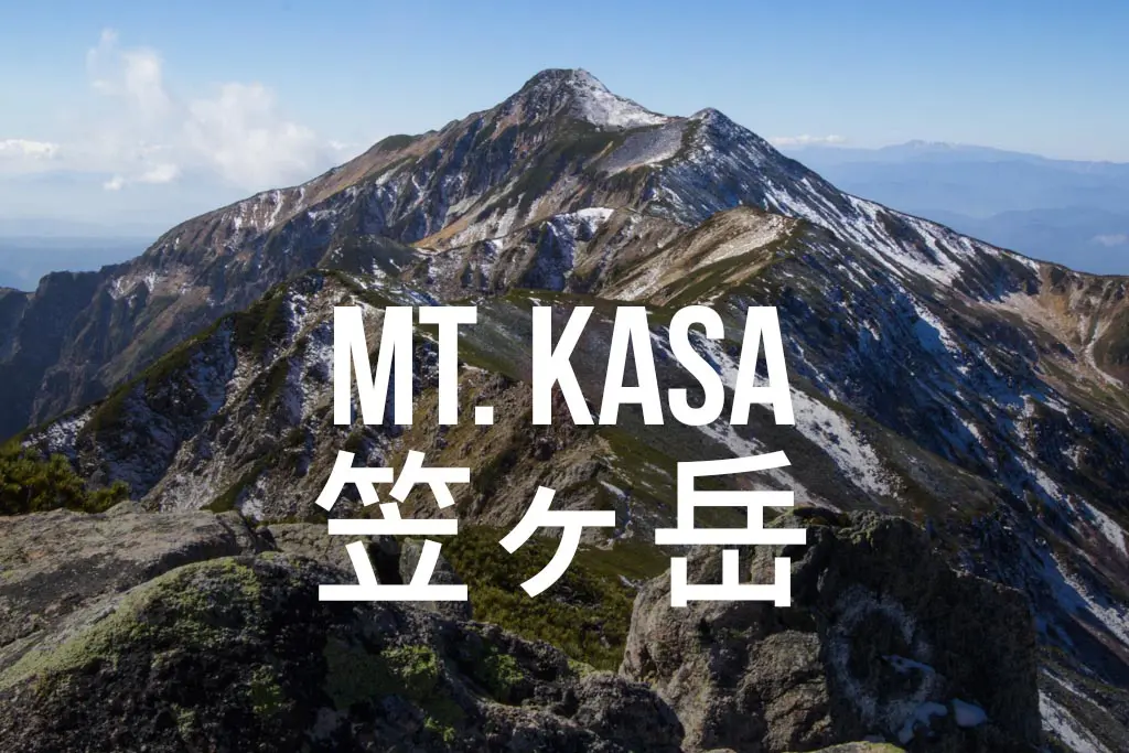
If the clouds aren’t in you’ll be able to see your destination from here. Yes, that’s Mount Kasa ahead of you, I hope you’ve still got some energy.

From here you’ll begin traversing and then climb up towards the peak of Mount Nukedo (抜戸岳). The trail wraps around the inside of the mountain before heading up a rocky chute to your next lookout point.
When you reach the junction below Nukedo’s peak, take a left (if your navigation skills are terrible and you’ve forgotten which peak is Kasa) to head out across the spine and towards your destination.
The trail does a good bit of up and down between Mount Nukedo and Mount Kasa (but mostly up), and it takes around an hour to reach lodge below the summit.

The lodge was already closed for the season when I hiked up (and apparently is home to a water source that I could not find), but this place may offer some good protection from the elements should you be able to break into it during the off-season.
From here, you only have a bit longer before hitting the summit just above.
The Summit
The rocky summit of Mount Kasa has plenty of space for activities (although it’s not the massive plateau of Mount Ibuki), and of course, a shrine so that you may pray to the mountain gods for safe passage down the mountain.

For your return trip you can either head down the way you came (the downhill after you pass Shakushidaira is brutal), or (apparently) traverse down to a different area of Shin-hotaka Hot Spring (I have no information on this alternate, but I know it’s possible).
Conclusion
If you’re up for a serious challenge and want to have your ass kicked, then Mount Kasa is exactly what you’re looking for.
If you want to start a Kita Alps adventure from Mount Kasa, then this can be a good launching point for a multi-day trip as well.


Hi,
There is indeed another way to climb mount Kasa. Starting at Shinhotaka onsen yarimikan, the path is steep but possible and well maintained (at least when we did it, beginning of August 2018).
We also wanted to thank you for this website that allowed us to hike in those montains during our japan trip. Information in english are hard to find, but thanks to you we were able to have this amazing weekend, one of the best hike we ever had for sure. So, thank you and keep on updating the website so that we have other part of Japan to discover on our next trip.
Martin and Emile Kern