
Hiking Mount Kanmuri (冠山) in Japan
- Name: Mount Kanmuri
- Japanese name: 冠山 (Kanmuriyama)
- Location: Ibigawa, Gifu (岐阜県揖斐川町) / Ikeda, Fukui (福井県池田町)
- Summit elevation: 4,123 ft / 1,256.6 m
- Elevation change: 703 ft / 214 m
- Round-trip distance from trailhead: 3.44 mi / 5.53 km
- Round-trip time from trailhead*: 2:20 moving time / 2:46 total time
- Difficulty: Easy-Moderate
- Water on trail: No
- Trailhead facilities: Free parking, bathroom
- Nihon Hyaku-meizan: No
Mount Kanmuri (冠山, Kanmuriyama) sits on the border of Fukui (福井) and Gifu (岐阜) in Japan’s Ryōhaku Mountains (両白山地).
The trailhead is not easy to get to, and if you don’t have your own transportation, then you’re out of luck (hitching here would be difficult).
For being as far out-of-the-way as it is, the hike is not particularly exciting, but perhaps that’s only because I climbed through the clouds without any views (which I suspect are excellent on a clear day).
*Note: The round-trip time listed above is based on my own experience. Please remember that your time may vary greatly.
Getting to Mount Kanmuri
- Region: Hokuriku (北陸地方)
- Accessible via public transportation: No
- Trailhead parking: Yes
- Trailhead coordinates: 35.788165, 136.392692
- Summit coordinates: 35.779855, 136.409235
BY CAR: From Fukui you will need to drive through Ikeda (池田) to arrive at the trailhead, and the road is quite narrow and almost looks like something you shouldn’t be driving on at times. You will need to pass through a construction area (as of 2015) and some unpaved roads to reach the trailhead, but don’t worry, you’re going the right way.
From Gifu you will follow 417 past the Tokuyama Dam (徳山ダム) and then into the mountains. Again, the road may seem too narrow or backwoodsy to be driving on, but don’t worry, you’re going the right way. Regardless of which direction you’re coming from, make sure you’ve got plenty of gas.
BY TRAIN OR BUS: Sorry, you definitely need your own transportation to get here (the trailhead is very remote).

The Hike
At the crest of the road and directly across from the trailhead there is a bathroom with a rancid smelling squat toilet and no running water. Honestly, if the drive up has gotten your bowels moving, then you’re probably better off digging a hole.
The hike up Mount Kanmuri begins with a short but steep uphill before leveling out for a bit and alternating between flat, uphill, and overgrown sections of trail.
If you’re fortunate enough to be climbing on a clear day, you’ll quickly get some great views of the area as you make your way along the ridgeline.
The trail is very easy to follow, but it could definitely use some maintenance in spots (crouching and/or climbing over fallen trees/shrubberies is required at points).

After about an hour of hiking you’ll come to an inconspicuous junction where heading left takes you to the Kanmuri Flats (a small open area where the trail runs out shortly thereafter) and right takes you up to the summit.
You will probably make the mistake of following the trail to the left, but don’t worry, you’ll only lose a couple of minutes and the trail remains in sight of the junction (basically, if you see a clearing in a saddle in front of you, then you need to turn around and go up).
After turning around to correct your trajectory, the trail begins a steep climb that doesn’t end until the summit.

Shortly after the junction, the trail arrives at a series of steep and rocky faces that need be maneuvered up and across to continue the climb. If not for this section I would have rated this trail as easy (but since I can’t imagine my Nana getting past this area, the “-Moderate” was necessary).
This section of the trail is not difficult to pass, but you’ll need to watch your footing, especially if it’s been raining. After this section, you’ll enter an overgrown area that climbs a bit further before spitting you out at the summit.
The Summit
Once you reach the summit of Mount Kanmuri, you can turn left to head over to the summit marker and a small clearing, or turn right where you can walk for a minute or two and see a view of something I could not see because of clouds (hopefully it’s glorious).
The eastern side of the summit (the side you’re facing when you arrive) has a steep vertical drop and a nice view of the valley below if the clouds don’t want to share the views of the surrounding mountains with you.

There isn’t much space at the summit so if you’re lucky you’ll get to make some new friends; if you’re unlucky you’ll just end up standing around awkwardly as the Japanese hikers boil and eat their noodles.

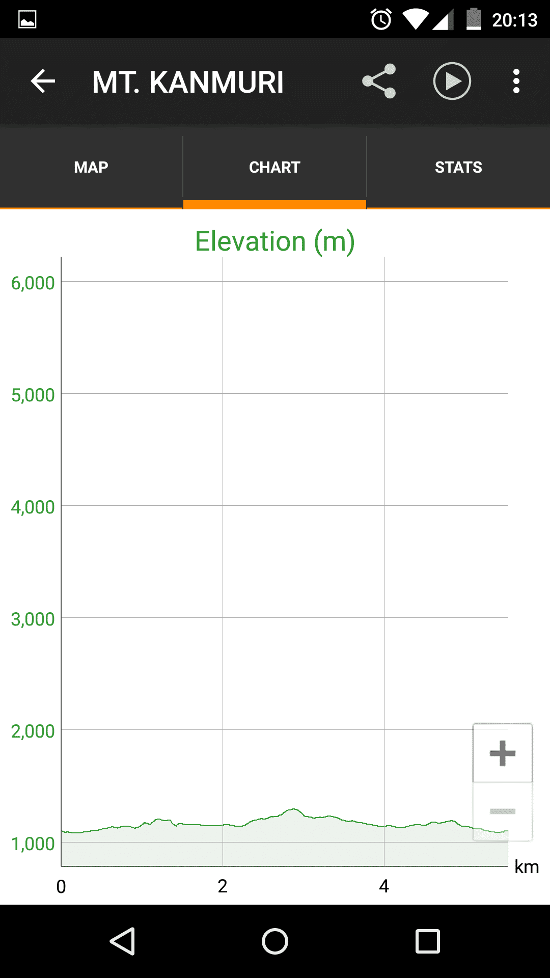
Map of Mount Kanmuri
The following was the route my GPS recorded on my hike up Mount Kanmuri.
I have no guarantee that this route is correct, nor that it can be accurately relied upon for backcountry navigation. It should serve only as a general guideline for what the trail is expected to look like.
I have also included the recorded elevation profile and hike’s overall stats in case any of you find any of it useful (imperial on the left, metric on the right).


Conclusion
Mount Kanmuri is seriously out of the way, and it isn’t very long of a hike either; you could easily spend as much time getting there and back as you do actually hiking.
It’s on the list of “Japan’s 100 Nature Spots to be Preserved in the 21st Century”, and even though I don’t know what the hell that means or why Japan insists on making arbitrary lists of 100 things, but some people hold this up as some sort of special distinction or reason to visit the mountain.
All I can say is that if you decide to make the trip out and up Mount Kanmuri, I hope you do so on a clear and beautiful day (which can be hard to judge from wherever you’re starting since the trailhead it quite remote).
Have any questions about Mount Kanmuri? Want another post about another one of Japan’s mountains? Have a suggestion to improve this information?
Leave a comment and let me know!


Above the clouds https://uploads.disquscdn.com/images/2672abd446feeb3cf09e5cf4dc66cf1ec9db3f0fe845f0dc3b188d743ee031c2.jpg
North https://uploads.disquscdn.com/images/7ded37fd19c96297f23a24ace85a5c4b7e29a4b62d8446c692c21d5371fdac97.jpg
Summit to ourselves – left the ramen at the trailhead.
https://uploads.disquscdn.com/images/b1bb33cf56703a7cff4b21e119d3a1be16f393cca90b3337fec2b2ff5d78939f.jpg https://uploads.disquscdn.com/images/44bc96457efe99f896ff7086c5d12b61358fa0f8e6a13e6a88ad5f8943c7fafd.jpg
Excellent (potential) views! https://uploads.disquscdn.com/images/b994d2da286ba206cbf336b750a09a94834f7772bdda9e1fa94606fdb34764d5.jpg
https://uploads.disquscdn.com/images/4bf92ece92875edfefd71ff33e219b911c1ebe602b760abee21039956017e7c0.jpg
https://uploads.disquscdn.com/images/9fe766e59f6958d1480f28e4cbdc4cdeb06185196e01d670472c1baa353e00ce.jpg Ridge ramble with occasional clouds
Kanmuri Flats before the summit pitch https://uploads.disquscdn.com/images/c2537b377321c7f7c4d27f1555a68b57ae134df5ad6e60934b6c3c20b47194d6.jpg
Thanks Mac – Great hike! Excellent info. Took my two boys on this ridge ramble and 360 peak. We were lucky to be mostly above the clouds which were mainly seaside of the ridge.
https://uploads.disquscdn.com/images/450ea00b9a7f0077736ede4586aa8b31c7c56e96da946385087f7599b4b31669.jpg
Awesome pictures, Adam!