Pacific Crest Trail Side Quests: Washington
Pacific Crest Trail side quests are objectives PCT hikers can choose to accomplish during their hikes, but that don’t need to be completed to finish a PCT thru-hike.
Before beginning a Pacific Crest Trail hike – or perhaps any thru-hike – it’s common for would-be hikers to spend vast amounts of time meticulously researching, planning, and mulling over their coming adventure.
Countless hours spent “planning” for a thru-hiker end up being instead a means of justifiably procrastinating anything else a PCT hiker could be doing before their hike – but I’m not here to judge. I’m here to do the opposite – to give you even more options when it comes to things to plan, research, and consider before setting out on a PCT hike.

Need to Know
Side quests are listed in geographical order from south to north. Some side quests are only applicable to Pacific Crest Trail hikers traveling in a particular direction (i.e., northbound or southbound).
I have assigned each of the Pacific Crest Trail side quests four ratings, an interest factor, difficulty factor, inconvenience factor, and a stupid factor.
All these are scored on a scale of 1 to 10 with a clarification of each scale below.
Also, the mileage used in all the below descriptions is based on data from FarOut. These mileages can change as the PCT is always being rerouted and (hopefully) improved – consider them approximate. If you aren’t already familiar with FarOut and you’re going to hike the PCT, you should invest in the app.
Interest Factor
Despite what you read in your overpriced guidebook, not all side quests are particularly interesting. This is an assessment of where the side quest falls on a scale of “not worth your time” to “absolutely should attempt”.
Difficulty Factor
It isn’t unreasonable to encounter a side quest that’s more challenging than any single stage of the Pacific Crest Trail. This is a rating of how difficult the side quest is to accomplish on a scale of “zero effort needed” to “significant physical or logistical effort needed”.
Inconvenience Factor
Sometimes a side quest might be interesting and easy, but it may be a huge hassle. This is a gauge of how inconvenient a side quest is on a scale of “will not alter your hike whatsoever” to “enormous pain in the ass”.
Stupid Factor
Some side quests have become part of Pacific Crest Trail lore and/or the PCT hiker culture that some may consider to be undeserving of such consideration. This metric rates how stupid a side quest is on a scale of “no at all” to “dumb af”.

Old Snowy Mountain (Trail)
Interest: ⭐⭐⭐⭐⭐⭐
Difficulty: ⚠️⚠️⚠️
Inconvenience: 😫😫😫
Stupid: 💩💩
Summary
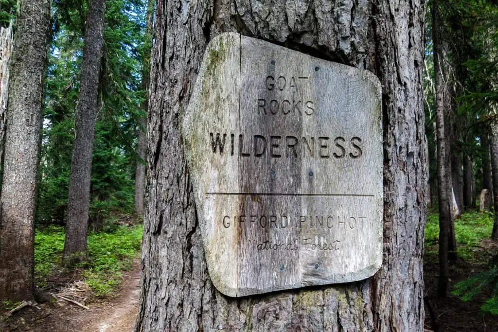
In Goat Rocks Wilderness, at northbound mile 2279 / southbound mile 375, there’s an alternate where Pacific Crest Trail hikers can take the old PCT route passing closer to Old Snowy Mountain instead of the newer route traversing further below.
This route is considered more scenic than the official PCT and taking this route will allow hikers to tag the summit of Old Snowy Mountain if they wish.
Interest
The Old Snowy Mountain Trail follows a ridgeline instead of traversing lower below Old Snowy Mountain. It’s slightly more difficult but it offers better views than the official Pacific Crest Trail.
Old Snowy Mountain is 7,880 ft / 2,401 m high and is the fifth-highest peak in the Goat Rocks Wilderness. It’s not a particularly famous peak, but its accessibility makes it worth considering.
Six points for the interest of this side quest. Why not take a more scenic alternative in what’s already one of the most scenic areas of the PCT?
Difficulty
The Old Snowy Mountain Trail is approximately 0.8 mi / 1.3 km long with 1,040 ft / 317 m of total elevation change. Alternatively, the Pacific Crest Trail here is 0.46 mi / 740 m with 368 ft / 112 m of total elevation change. This means the alternate is 0.34 mi / 547 m longer with 672 ft / 205 m more elevation change.
Another 0.16 mi / 258 m of hiking (one way) with 258 ft / 78 m of climbing will get hikers to the summit of Old Snowy Mountain. The trail’s grade is steeper than that of most of the Pacific Crest Trail, but it isn’t anything that should prove too difficult for PCT hikers.
Inconvenience
Three points for inconvenience because this side quest requires you to do extra elevation gain in what could potentially be hazardous if conditions are bad. That said, you won’t be adding much mileage or time to your overall hike if you choose to complete this side quest.
Stupid
Two points instead of one point for stupid here because arguments could be made against this side quest by purists wanting to hike the entire official Pacific Crest Trail, by those who don’t want to do any “unnecessary” elevation gain, or by those who find themselves here in hazardous conditions.
The Wonderland Trail
Interest: ⭐⭐⭐⭐⭐⭐⭐
Difficulty: ⚠️⚠️⚠️⚠️⚠️
Inconvenience: 😫😫😫😫😫😫😫😫😫
Stupid: 💩💩💩💩💩
Summary
The Wonderland Trail is a 93-mile (150-km) trail that circumnavigates Tahoma/Mount Rainier in Mount Rainier National Park. It’s probably the most well-known long-distance hiking trail that’s entirely contained within Washington.
The Pacific Crest Trail does not overlap with the Wonderland Trail at all (unlike Oregon’s Timberline Trail), but it does pass within 14 mi / 22.5 km at PCT northbound mile 2315.6 / southbound mile 339.6. You can hike west to the Wonderland Trail here without any road walking.
Interest
Every year, hundreds, if not thousands, of hikers attempt to get Wonderland Trail permits, but only a small percentage of them will end up with one. It’s one of Washington’s most well-known hiking trails. The Pacific Crest Trail passes east of Tahoma/Mount Rainier and you won’t get the best up-close views of the peak as a PCT hiker.
Seven points for the interest of the Wonderland Trail. It would be more, but the inconvenience factor knocks it down a bit.
Difficulty
The Wonderland Trail isn’t technically difficult (unless perhaps you’re an early-season southbound hiker) and any Pacific Crest Trail hiker should be able to manage the physical demands of a Wonderland Trail hike.
However, what’s difficult about the trail is the additional logistics hikers wishing to complete the circuit will have to manage. Five difficulty points.
Inconvenience
Hiking the Wonderland Trail gets nine points for inconvenience because it will require you to deal with an additional (or incredibly long) resupply and navigate the Wonderland Trail permitting system as well. It is possible to get a walk-up permit for the Wonderland Trail, but this would mean potentially wasting days waiting for a permit. Check out the Wonderland Trail backpacking guide for more information.
Stupid
It’s a little stupid to hike the Wonderland Trail during a Pacific Crest Trail thru-hike. Then again, I could see an argument being made for it not being stupid.
If you’re on the West Coast of the United States for what may be your only time, have the time and patience to tackle the logistical hurdles, and really want to hike the Wonderland Trail, maybe it’s a good idea (if doing so won’t compromise your PCT hike – unless you don’t care about that).
Then again, I can’t imagine this is something many PCT hikers will take on during their hikes – five stupid points. It’s the kind of thing that if someone told me they did it my first reaction would be “Why?” but then after a moment, I would probably think “Cool”.

Glacier Peak
Interest: ⭐⭐⭐⭐⭐⭐⭐
Difficulty: ⚠️⚠️⚠️⚠️⚠️⚠️⚠️
Inconvenience: 😫😫😫😫😫
Stupid: 💩💩💩💩
Summary
Glacier Peak is the most isolated stratovolcano in the Cascade Range. It’s 10,525 ft / 3,207 m high with a prominence of 7,498 ft / 2,285 m. The Glacier Peak Wilderness, where Glacier Peak is located, is consistently one of Pacific Crest Trail hikers’ favorite sections of the trail (according to the PCT Hiker Survey).
Hikers can depart the Pacific Crest Trail at northbound mile 2505.2 / southbound mile 150 and make a 14.4 mi / 23.2 km roundtrip hike to the summit with 11,136 ft / 3,394 m of elevation change. For more on climbing Glacier Peak, check out its page on Summit Post.
Interest
Seven points of interest for summiting Glacier Peak. One more than Mount Adams due to Glacier Peak’s remoteness; Mount Adams can be more easily reached from a trailhead than Glacier Peak. The peak is prominent and visible to Pacific Crest Trail hikers throughout the Glacier Peak Wilderness.
Hiking to the summit of Glacier Peak is a great way to spice up a PCT hike, but like the other peaks in Washington, it’s not a must-do. That said, it is a most excellent side quest.
Difficulty
It’s 7.2 mi / 11.6 km and just under 5,600 ft / 1,700 m of climbing to the summit of Glacier Peak from the Pacific Crest Trail. The trail to the summit of Glacier Peak is more challenging than any of the terrain hikers will find on the PCT and it may be necessary to bring an ice axe and traction to make it to the summit (depending on conditions, weather, and your experience).
Seven points for difficulty.
Inconvenience
A roundtrip climb to Glacier Peak from the Pacific Crest Trail will likely cost you a day in what’s one of the longest resupply stretches of the PCT at 126.9 mi / 204.2 km – between Stevens Pass/Highway 2 and Rainy Pass/Highway 20.
If you have a good weather window, most of the inconvenience will come from the extra day’s worth of food, the potentially extra gear you’ll have, and the physical demands of making a roundtrip journey to the summit. Five points for inconvenience.
Stupid
Four points for the stupid level of this side quest. Glacier Peak is by no means a must-do side quest, but it is quite an interesting/challenging one for those willing to take it on. Climbing the peak in bad weather or attempting the route without proper gear or experience can greatly increase the stupidity of this side quest.

Mount Adams
Interest: ⭐⭐⭐⭐⭐⭐
Difficulty: ⚠️⚠️⚠️⚠️⚠️⚠️⚠️
Inconvenience: 😫😫😫😫
Stupid: 💩💩💩💩💩
Summary
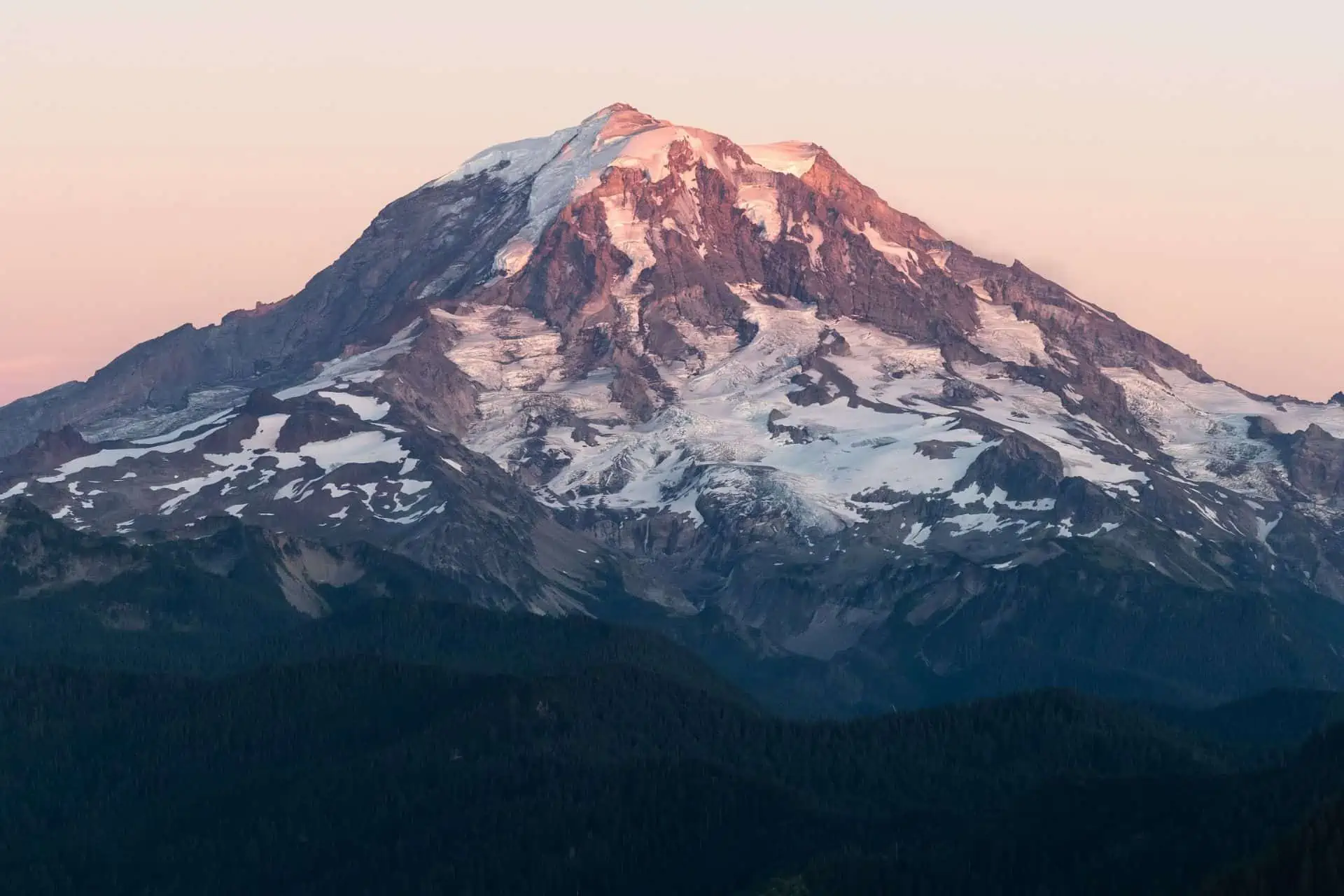
Mount Adams is a potentially active stratovolcano (it hasn’t erupted in over 1,000 years – but it could!) in Southern Washington, and at 12,281 ft / 3,743 m, it’s the second-highest peak in the state after Tahoma/Mount Rainier.
From the closest point on the PCT, a roundtrip hike to the summit of Mount Adams is 20.6 mi / 33.2 km with approximately 13,600 ft / 4,145 m of elevation change from PCT northbound mile 2238.2 / southbound mile 417.
For more on climbing Mount Adams, you can check out the Forest Service website.
Interest
Six points of interest for summiting Mount Adams. It’s a prominent mountain that’s within view of the Pacific Crest Trail for quite a while. Climbing Mount Adams is certainly an awesome side quest, but it’s nowhere near a must-do as far as the PCT is concerned. Nobody is going to say to you, “WHAT?! You hiked the PCT and you didn’t summit Mount Adams!?”
Difficulty
Seven points for the difficulty of the Mount Adams sidequest. Its proximity to the Pacific Crest Trail is surprisingly close.
From PCT northbound mile 2238.2 / southbound mile 417, it’s 10.3 mi / 16.6 km to the summit. The trail climbs nearly 6,800 ft / 2,073 m over this distance making it significantly steeper than any single section of the PCT.
The terrain will be much more difficult than anything hikers will find on the PCT and you’ll likely need an ice axe and traction for your shoes (potentially crampons). However, what you’ll need will vary depending on your experience, the conditions, and the weather.
Inconvenience
If you decide to summit Mount Adams, you’ll need to purchase an additional permit, the Mount Adams Climbing Activity Pass. For more on the pass (and to purchase one), check out Recreation.gov. Note: you are required to use a wag bag if you climb Mount Adams.
As noted above, it’s also realistic that a Mount Adams climb will mean carrying additional equipment between White Pass and Trout Lake.
Stupid
Three stupid points for tagging the Mount Adams summit. It’s likely not going to be a side quest many Pacific Crest Trail thru-hikers attempt, but it will be one that should prove a worthy adventure for those who do.
Remember, you can always increase the stupid factor greatly by attempting this without the proper experience or equipment.

Start or End via Ross Lake
Interest: ⭐⭐⭐⭐⭐
Difficulty: ⚠️⚠️⚠️⚠️
Inconvenience: 😫😫😫
Stupid: 💩💩
Summary
Technically, the Pacific Crest Trail begins and/or ends at the US-Canada border. However, the northern terminus of the PCT is not accessible via car. This means northbound hikers will have to continue hiking to finish the PCT and southbound hikers will have to do extra miles if they wish to tag the northern terminus before beginning.
Northbound hikers have a few options when they reach the northern terminus: hike northbound to Manning Park in Canada (granted they’ve obtained permission in advance), backtrack on the PCT to Harts Pass, or backtrack on the PCT to Castle Pass and then hike westbound to Ross Lake.
It’s 36 mi / 58 km from Castle Pass to East Bank Trailhead at Highway 20. Hikers can use this trailhead as a starting or an ending point of the Pacific Crest Trail.
Interest
Five interest points for this side quest. If you do not have permission to hike into Canada or you’re a southbound hiker beginning their hike, this is a more interesting option than retracing the same trail to/from Harts Pass.
If you’re feeling adventurous, want to carry extra food, and hike some extra miles, you could even pop up and tag the US-Canada border a second time just south of Ross Creek Campground on the eastern shore of Ross Lake.
Difficulty
From the northern terminus to Manning Park, it’s 7.8 mi / 12.6 km with 2,000 ft / 610 m of elevation gain and 2,360 ft / 720 m of elevation loss. This is the easiest option for Pacific Crest Trail hikers ending their journey.
It’s 3.6 mi / 5.6 km from the northern terminus to Castle Pass.
From Castle Pass to Ross Lake and the East Bank Trailhead at Highway 20, it’s 36 mi / 58 km with 10,617 ft / 3,236 m of elevation gain and 14,269 ft / 4,349 m of elevation loss.
From Castle Pass to Harts Pass it’s 26.2 mi / 42.16 km with 7,472 ft / 2,277 m of elevation gain and 6,819 ft / 2,078 m of elevation loss.
This means a hike out via Ross Lake requires an additional 9.8 mi / 15.8 km of hiking, 3,145 ft / 959 m more climbing, and 7,450 ft / 2,271 m of extra descent. More difficult than the other two options for hiking out, but not insanely difficult on its own. Four points for difficulty.
Inconvenience
Hiking out via Ross Lake requires an additional 9.8 mi / 15.8 km of hiking, 3,145 ft / 959 m more climbing, and 7,450 ft / 2,271 m of extra descent. Inconvenient? Certainly more so than the other two hiking alternatives.
However, hiking out or in via Ross Lake means hikers will be beginning or ending at a trailhead along the well-traveled and easily accessible Highway 20. This trailhead is far more convenient to reach than Harts Pass Trailhead or Manning Park in Canada.
Three points for inconvenience here since the spot you’ll start/end is more convenient but the hike to/from it is more inconvenient.
Stupid
I don’t see much stupid about this option if you are a southbound hiker beginning the Pacific Crest Trail or you’re a northbound hiker who can’t or doesn’t want to hike into Canada. Two stupid points instead of one because if you do have permission to hike into Canada, that’s a fairly neat alternative if you have the means to get back afterward.

Hike into Canada
Interest: ⭐⭐⭐⭐⭐⭐⭐⭐⭐⭐
Difficulty: ⚠️⚠️
Inconvenience: 😫😫😫
Stupid: 💩
Summary
Northbound hikers have a few options when they reach the northern terminus: hike northbound to Manning Park in Canada (granted they’ve obtained permission in advance), hike back on the Pacific Crest Trail to Harts Pass, or hike out via Ross Lake to the west (another side quest).
Manning Park in Canada, east of Vancouver, is the closest road-accessible location to the northern terminus of the Pacific Crest Trail. Hiking here is often the final side quest of the PCT.
Unfortunately, this side quest is not available to southbound hikers as there is no legal way to hike into the United States from Canada (don’t do this).
Interest
Maximum interest points for hiking into Canada. If you’re a northbound thru-hiker and you can obtain permission to hike into Canada via the Pacific Crest Trail, I would consider this a must-do. The PCT is full of novel experiences, and crossing an international border on foot in the middle of the woods is certainly up there as far as uniqueness goes.
Difficulty
The trail from the Pacific Crest Trail’s northern terminus to Manning Park is 7.8 mi / 12.6 km with 2,000 ft / 610 m of elevation gain and 2,360 ft / 720 m of elevation loss. Of all the options available to PCT hikers at the northern terminus, this is by far the easiest. At least as far as the physical demands of this hike are concerned.
Two points for difficulty since it’s not quite as easy as just stopping to look at something and you’re essentially required to do it (unless you for some reason have to call search and rescue and get carried/helicoptered out of the wilderness).
Inconvenience
Hikers wanting to enter Canada via the Pacific Crest Trail will have to obtain permission in advance. The Pacific Crest Trail Association has all the information you need about obtaining this.
It’s not a difficult application but if you don’t have an American or Canadian passport, you have visa issues that complicate this process. Also, there are multiple reasons why your application can be denied as an American. Be sure to follow the directions carefully when submitting your paperwork.
Three inconvenience points for this side quest.
Stupid
Minimum stupid points for this side quest. Being able to hike into Canada at the end of your Pacific Crest Trail thru-hike is awesome. How often do you get to cross an international border in the middle of the woods?

Wrap Up
It’s easy to get excited when planning a Pacific Crest Trail hike and imagine you’re going to do ALL THE THINGS. However, the reality is often different from the idealistic plans you make beforehand.
Oftentimes, you’ll be exhausted from hiking, and the thought of venturing off the PCT or adding any complications to your thru-hike will seem like madness. That said, other times you may be inspired to put in some extra effort and get some bonus XP.
Have a Pacific Crest Trail Washington side quest that you believe is worthy of making this list? Know of a Washington side quest that more PCT hikers should be taking advantage of?
Leave a comment below or get in touch!
Affiliate Disclosure: This page may contain affiliate links, which means I may receive small commissions for purchases made via these links at no additional cost to you. This helps pay the bills and keep the site up and running. Thank you for your support!


You could also suggest the Maple Pass Loop, starting and arriving Rainy Pass. I didn’t hike it from PCT because the day I was at Rainy Pass, all these are was cloud covered, but I went back to do it after finishing. A bit less than 10 miles, 2200 feet elevation but well maintained trail, between 3 and 4 hours long. One of the nicest hike in Wasington and North Cascades and I would definitly recommand it to a PCT hiker if weather’s fine at Rainy Pass
A more long but great adventure could be taking 3-4 days from Stehekin to hike to Cascade Pass and Sahale Glacier and back. Cascade Pass must be around 20 miles from High Bridge, then around 3 miles to the Glacier. Would need to get a wilderness permit in Stehekin and check weather condition. I did Cascade Pass and Sahale Glacier from its trailhead after finishing PCT when I went back in North Cascades, maybe my most beautiful day in Washington. At least as nice as Goat Rocks.
I anticipate that a detour from Rainy Pass would be either too early or too late for many PCT hikers eager to begin (or end) their journies, but that’s a great suggestion.
Sahale Glacier and Cascade Pass look awesome!
I’m surprised you didn’t include the Goldmyer Hot Springs alternate as a side quest.
As it so happens, I’ve crossed the US/Canada border twice in the middle of the wilderness, though the second time wasn’t in the middle of the woods but in alpine terrain (Chilkoot Pass). It features exciting things you don’t see at the northern end of the PCT, such as archeological artifacts from the 19th century and an avalanche zone on the Canadian side where I was instructed to not stop at all, not even for a quick break. The Chilkoot border crossing has been closed since 2020 (I went there in 2019, the last year international crossings were legal), but if it ever reopens, I highly recommend it.
I meant to and completely forgot! I will get on adding that now.
I actually did this alternate during my first PCT hike and I included it as part of my Best PCT Section Hikes of Washington: https://www.halfwayanywhere.com/trails/pacific-crest-trail/best-section-hikes-pct-washington/