Hayduke Trail Hiking Data and Stats
I’ve decided to put out my Hayduke Trail hiking stats to help future Hayduke hikers (Haydukers or Haydookies) plan their trips and manage their expectations.
There’s so much variation in the Hayduke that you could literally “hike the Hayduke” twice and have not only a completely different experience each time (a spring vs. fall hike, for example), but you could also have minimal physical overlap in the trail you’re on from one hike to the next. Often, people refer to the Continental Divide Trail (CDT) as a choose-your-own-adventure trail, but the CDT is a far second to the Hayduke when it comes to adventure choosing.
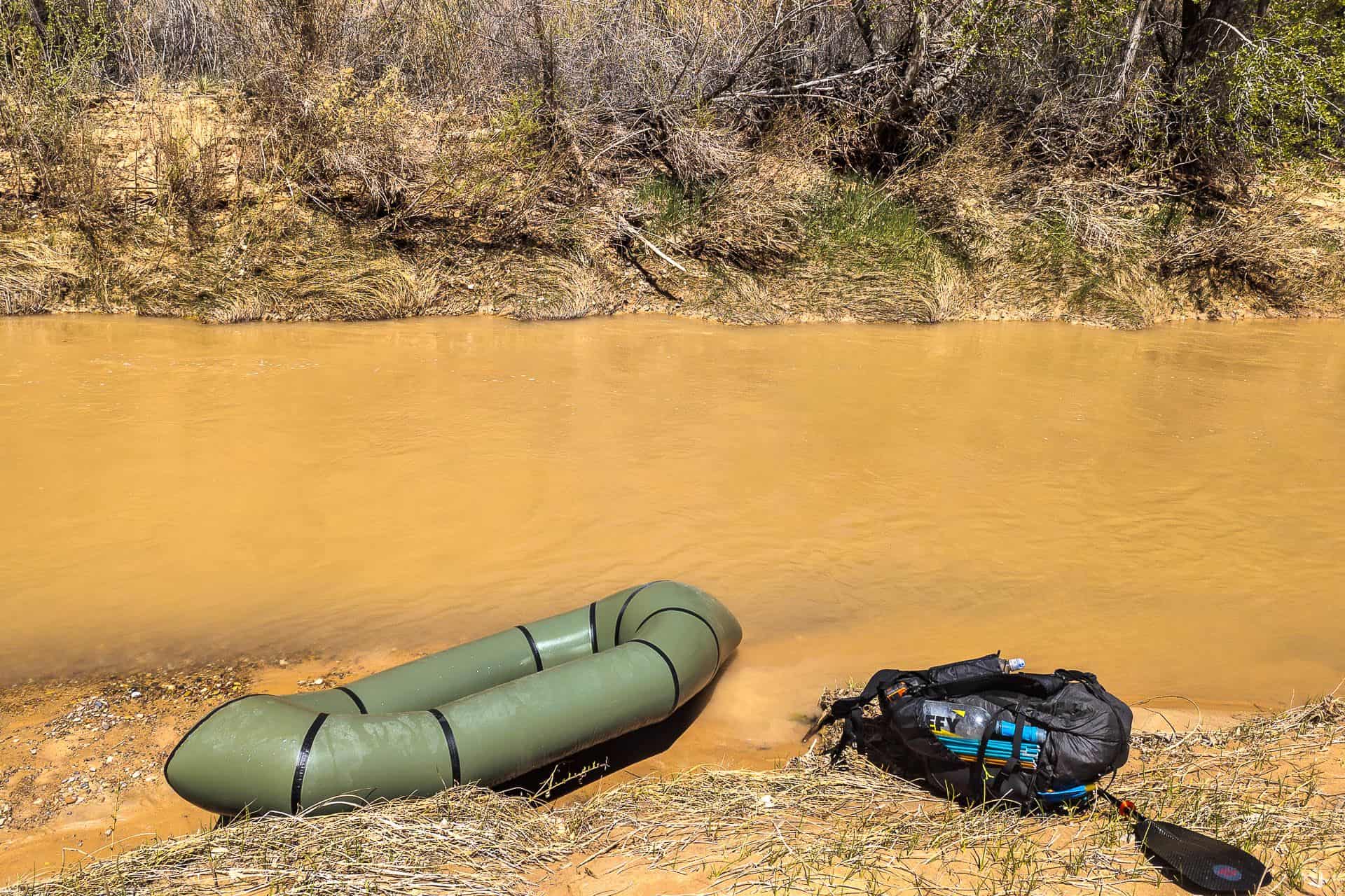
Before delving into the data, it’s worth pointing out a few key features of my Hayduke hike: I hiked in spring, it was a higher-than-average snow year, I took an extended break to go on a rafting trip and let Grand Canyon creek levels drop, and I packrafted 60.18 mi / 95.85 km of the route. But more on all this below.

Notes on My Hike
The Hayduke – more than many other long-distance hikes – is a route filled with alternates, detours, side quests, and optional adventures that make each person’s thru-hike unique. I wager it would not be easy to find two people who hiked the Hayduke (not together) and ended up taking the same route (regardless of the time it took them).
Here are the notes to remember when reviewing the data from my Hayduke thru-hike.
- On Day 3, in the tables below, I only hiked 4.05 mi / 6.52 km because I left Moab in a thunderstorm and then thought to myself, “Why the hell am I leaving town in terrible weather?” I hitchhiked back to town (you’re on a paved and then a dirt road leaving Moab), stayed the night, and left the next morning after the storm.
- The distance from Moab to Needles Outpost is a bit off from a more traditional Hayduke hike because I hiked from Moab to a beach south of Basecamp Adventure Lodge via the official route and then hiked back to Moab via the Jackson Hole Alternate. I then hiked from Moab back north to the Colorado River and packrafted down to Basecamp Adventure Lodge. Why? Good question. More on why you shouldn’t do this here.
- I took a double zero in Hanksville, not because I wanted to but because I had to wait for a phone to arrive at the post office (I do not trust overnight shipping to these small towns). This second phone was my backup navigation device in case my primary phone failed.
- I took an extended break from the Hayduke (to raft the Desolation Gray Canyons section of the Green River) after reaching Jacob Lake (Days 35-45). This was to (hopefully) allow the creeks in Grand Canyon National Park some time to recede, as they were all still running high from the spring snowmelt.
- The North Kaibab Trail (the typical route out of the Grand Canyon after stopping at the South Rim) was closed due to rockfall. This forced me to take an extremely circuitous route, first hiking west from Grand Canyon Village to the South Bass Trail, down the South Bass Trail to the Colorado River, where I had to hitch a ride on a raft to cross, and then up North Bass Trail to reconnect with the Hayduke at Muave Saddle/Teddy’s Cabin. This was further complicated because it took nearly 24 hours to find a safe place to cross Shinumo Creek, which was in flood.
- Long story short: other Hayduke hikers met me and the people I was hiking with at Hack Canyon Trailhead (with a vehicle), and we ended up hiking a shorter day (May 25, Day 59) and going into Kanab to spend the night/resupply. This is not a typical place where people hitch into town, although it is possible (but may be difficult). It is less than 40 mi / 64 km from this spot to the next resupply spot in Colorado City/Hilldate (also, Colorado City/Hilldate is called Colorado City/Hilldate because it straddles the Arizona/Utah border. Colorado City is in Arizona, and Hilldale is in Utah; however, they’re essentially the same town as far as Hayduke hikers are concerned.
- The original route the Hayduke follows into Zion National Park at the trail’s western terminus is closed indefinitely due to rockfall. Instead of hiking to the highway in Zion and hitchhiking through the tunnel to finish, I hiked north out of Hilldale/Colorado City through the Canaan Mountain Wilderness into Rockville, then west from Rockville, and then north into the western half of Zion before taking an off-trail route over a pass (Around Zion Alternate) and then hiking the West Rim Trail down into the valley.

Hayudke Alternates
There are a ton of alternates on the Hayduke Trail (I’ll cover them in more detail in a separate post).
The following is an overview of the alternates, detours, shortcuts, or side quests I completed during my Hayduke thru-hike. Yes, it’s a lot.
- Devils Garden Alternate in Arches National Park (to begin the route)
- Unknown Alternate bypassing Lower Courthouse Wash in Arches National Park
- The Jackson Hole Alternate south of Moab (this was hiked in reverse back to Moab after hiking the main Hayduke route to where they intersect)
- Needles Outpost/Visitor Center “Fast” Route in Canyonlands National Park
- Salt Creek to Beef Basin Alternate (to Peekaboo Connector Route) in Canyonlands National Park
- Peekaboo Connector Route (to Heart of the Needles Alternate) in Canyonlands National Park
- Heart of the Needles Alternate (from where it connects to the Peekaboo Connector Route back to the main route) in Canyonlands National Park
- An early route up from the Dirty Devil, which connected to a road that intersected the Hayduke
- A lower route through the Henry Mountains along Henry Mountains Road (there was a lot of snow in the Henrys
- Under Tarantula Alternate
- Reese Saddle Shortcut
- Upper Paradise Alternate
- Bryce Canyon Extension via Tropic
- Made up alternate paralleling Arizona Trail south to Jacob Lake after climbing up to Kaibab Plateau south of Stateline Campground
- A low route via Buffalo Ranch/Houserock Road to reach the Nankoweap Trail Trailhead and then reconnect with the Hayduke at the Grand Canyon National Park boundary
- South Bass Trail to North Bass Trail in Grand Canyon National Park (because the North Kaibab Trail was closed)
- Forest Service roads from North Bass Trailhead to Bill Hall Trailhead to Thunder River Trail to bypass Tapeats Creek
- Water Canyon Road and trail north out of Colorado City/Hilldate to Around-Zion Alternate
- Zion Traverse West Extention into Zion National Park (from Around-Zion Alternate) from the west

Totals and Averages
- Total Days: 64
- Zero Days: 19 (see above if you skipped here and are wondering why I took so many zeroes)
- Hiking Days: 46
- Nearo Days (< 10 mi / 16 km): 6
- Total Distance Hiked: 894.54 mi / 1,439.62 km
- Total Elevation Gain: 116,628 ft / 35,548 m
- Average Daily Pace (hiking days only): 19.45 mi / 31.1 km
- Average Daily Elevation Gain (hiking days only): 2,535 ft / 773 m
- Median Elevation Gain: 111 ft/mi or 21 m/km
- Miles Packrafted: 60.18 mi / 95.85 km
- Total Distance Covered: 954.72 mi / 1,536 km
- Resupplies: 9
- Average Distance Between Resupplies: 106.08 mi / 170.72 km
- Longest Day of Hiking: 32.72 mi / 52.65 km with 984 ft / 300 m of elevation gain (you’re not reading that incorrectly; it was absurdly flat) from Lick Wash to Stateline Campground via Upper Buckskin Gulch and Wire Pass with an average elevation gain of 30 ft/mi or 4.5 m/km
- Most Elevation Gain in a Day: 6,532 ft / 1,991 m over 16.11 mi / 25.92 km from Shinumo Creek to Muav Saddle via North Bass Trail (this is not part of a typical Hayduke hike – I was forced to do this because the North Kaibab Trail was closed) with an average elevation gain of 405 ft/mi or 77 m/km
- Times Snow Encountered: 4 – Dark Canyon Plateau, Henry Mountains, Bryce Canyon National Park, Kaibab Plateau (North Rim of Grand Canyon)

Town Data (Imperial)
| Distance (mi) | Elevation Gain (ft) | Days | Nights | ||
|---|---|---|---|---|---|
| Start | Moab | 31.72 | 3,304 | 2 | 1 |
| Moab | Needles Outpost | 81.50 | 10,637 | 3 | 2 |
| Needles Outpost | Hanksville | 113.12 | 13,127 | 5 | 4 |
| Hanksville | Escalante | 129.84 | 13,455 | 6 | 5 |
| Escalante | Tropic | 124.95 | 11,929 | 5 | 4 |
| Tropic | Jacob Lake | 108.48 | 12,786 | 4 | 3 |
| Jacob Lake | Grand Canyon Village | 103.07 | 19,166 | 5 | 4 |
| Grand Canyon Village | Kanab | 136.17 | 20,418 | 8 | 7 |
| Kanab | Colorado City/Hilldale | 30.09 | 1,542 | 3 | 2 |
| Colorado City/Hilldale | Finish | 51.51 | 9,738 | 3 | 2 |
Town Data (Metric)
| Distance (km) | Elevation Gain (m) | Days | Nights | ||
|---|---|---|---|---|---|
| Start | Moab | 51.04 | 1007 | 2 | 1 |
| Moab | Needles Outpost | 131.13 | 3242 | 3 | 2 |
| Needles Outpost | Hanksville | 182.01 | 4001 | 5 | 4 |
| Hanksville | Escalante | 208.91 | 4101 | 6 | 5 |
| Escalante | Tropic | 201.04 | 3636 | 5 | 4 |
| Tropic | Jacob Lake | 174.54 | 3897 | 4 | 3 |
| Jacob Lake | Grand Canyon Village | 165.84 | 5842 | 5 | 4 |
| Grand Canyon Village | Kanab | 219.10 | 6223 | 8 | 7 |
| Kanab | Colorado City/Hilldale | 48.41 | 470 | 3 | 2 |
| Colorado City/Hilldale | Finish | 82.88 | 2968 | 3 | 2 |

Data Table (Imperial)
| Day | Hiking Day | Date | Miles | Gain (ft) | Total (mi) | Cumulative Gain (ft) | Packraft (mi) |
|---|---|---|---|---|---|---|---|
| 1 | 1 | March 28 | 14.09 | 1,575 | 14.09 | 1,575 | 0 |
| 2 | 2 | March 29 | 17.63 | 1,729 | 31.72 | 3,304 | 0 |
| 3 | 3 | March 30 | 4.05 | 125 | 35.77 | 3,429 | 0 |
| 4 | 4 | March 31 | 30.32 | 3,045 | 66.09 | 6,474 | 0 |
| 5 | 5 | April 1 | 6.72 | 302 | 72.81 | 6,776 | 0 |
| 6 | 6 | April 2 | 4.16 | 99 | 76.97 | 6,875 | 0 |
| 7 | 7 | April 3 | 26.13 | 5,020 | 103.10 | 11,895 | 19.22 |
| 8 | 8 | April 4 | 25.05 | 2,572 | 128.15 | 14,467 | 0 |
| 9 | — | April 5 | 0 | 0 | 128.15 | 14,467 | 0 |
| 10 | 9 | April 6 | 22.90 | 2,808 | 151.05 | 17,275 | 0 |
| 11 | 10 | April 7 | 26.63 | 3,100 | 177.68 | 20,375 | 0 |
| 12 | 11 | April 8 | 20.79 | 3,097 | 198.47 | 23,472 | 0 |
| 12 | 12 | April 9 | 28.82 | 2,583 | 227.29 | 26,055 | 0 |
| 13 | 13 | April 10 | 13.98 | 1,539 | 241.27 | 27,594 | 0 |
| 15-16 | — | April 11-12 | 0.00 | 0 | 241.27 | 27,594 | 0 |
| 17 | 14 | April 13 | 14.71 | 4,669 | 255.98 | 32,263 | 0 |
| 18 | 15 | April 14 | 24.88 | 2,421 | 280.86 | 34,684 | 0 |
| 19 | 16 | April 15 | 25.61 | 1,529 | 306.47 | 36,213 | 0 |
| 20 | 17 | April 16 | 20.82 | 2,572 | 327.29 | 38,785 | 0 |
| 21 | 18 | April 17 | 0 | 0 | 327.29 | 38,785 | 0 |
| 22 | 19 | April 18 | 12.98 | 2,264 | 340.27 | 41,049 | 26.03 |
| 23 | — | April 19 | 0 | 0 | 340.27 | 41,049 | 4.81 |
| 24 | 20 | April 20 | 10.95 | 3,501 | 351.22 | 44,550 | 0 |
| 25 | 21 | April 21 | 22.71 | 2,070 | 373.93 | 46,620 | 0 |
| 26 | 22 | April 22 | 30.03 | 2,851 | 403.96 | 49,471 | 0 |
| 27 | 23 | April 23 | 30.84 | 1,765 | 434.80 | 51,236 | 0 |
| 28 | 24 | April 24 | 30.42 | 1,742 | 465.22 | 52,978 | 0 |
| 29-30 | — | April 25-26 | 0 | 0 | 465.22 | 52,978 | 0 |
| 31 | 25 | April 27 | 21.00 | 5,135 | 486.22 | 58,113 | 0 |
| 32 | 26 | April 28 | 27.87 | 3,104 | 514.09 | 61,217 | 0 |
| 33 | 27 | April 29 | 32.72 | 984 | 546.81 | 62,201 | 0 |
| 34 | 28 | April 30 | 26.89 | 3,563 | 573.70 | 65,764 | 0 |
| 35-45 | — | May 1-11 | 0 | 0 | 573.70 | 65,764 | 0 |
| 46 | 29 | May 12 | 22.95 | 1,837 | 596.65 | 67,601 | 0 |
| 47 | 30 | May 13 | 20.18 | 3,717 | 616.83 | 71,318 | 0 |
| 48 | 31 | May 14 | 19.09 | 4,006 | 635.92 | 75,324 | 0 |
| 49 | 32 | May 15 | 26.60 | 4,780 | 662.52 | 80,104 | 3.53 |
| 50 | 33 | May 16 | 14.25 | 4,826 | 676.77 | 84,930 | 0 |
| 51 | — | May 17 | 0 | 0 | 676.77 | 84,930 | 0 |
| 52 | 34 | May 18 | 27.47 | 1,677 | 704.24 | 86,607 | 0 |
| 53 | 35 | May 19 | 7.96 | 2,146 | 712.20 | 88,753 | 0 |
| 54 | 36 | May 20 | 16.11 | 6,532 | 728.31 | 95,285 | 0 |
| 55 | 37 | May 21 | 27.36 | 3,760 | 755.67 | 99,045 | 0 |
| 56 | 38 | May 22 | 15.94 | 1,713 | 771.61 | 100,758 | 0 |
| 57 | 39 | May 23 | 9.37 | 1,585 | 780.98 | 102,343 | 0 |
| 58 | 40 | May 24 | 24.02 | 1,883 | 805.00 | 104,226 | 0 |
| 59 | 41 | May 25 | 7.94 | 1,122 | 812.94 | 105,348 | 0 |
| 60 | 42 | May 26 | 11.28 | 741 | 824.22 | 106,089 | 0 |
| 61 | 43 | May 27 | 18.81 | 801 | 843.03 | 106,890 | 0 |
| 62 | 44 | May 28 | 21.82 | 4,613 | 864.85 | 111,503 | 0 |
| 63 | 45 | May 29 | 14.16 | 3,474 | 879.01 | 114,977 | 0 |
| 64 | 46 | May 30 | 15.53 | 1,651 | 894.54 | 116,628 | 0 |
Data Table (Metric)
| Day | Hiking Day | Date | Km | Gain (m) | Total (km) | Cumulative Gain (m) | Packraft (km) |
|---|---|---|---|---|---|---|---|
| 1 | 1 | March 28 | 22.67 | 480.21 | 22.67 | 480.21 | 0 |
| 2 | 2 | March 29 | 28.37 | 527.17 | 51.04 | 1,007.38 | 0 |
| 3 | 3 | March 30 | 6.52 | 38.11 | 57.55 | 1,045.49 | 0 |
| 4 | 4 | March 31 | 48.78 | 928.41 | 106.34 | 1,973.90 | 0 |
| 5 | 5 | April 1 | 10.81 | 92.08 | 117.15 | 2,065.98 | 0 |
| 6 | 6 | April 2 | 6.69 | 30.18 | 123.84 | 2,096.17 | 30.92 |
| 7 | 7 | April 3 | 42.04 | 1,530.58 | 165.89 | 3,626.75 | 0 |
| 8 | 8 | April 4 | 40.31 | 784.19 | 206.19 | 4,410.94 | 0 |
| 9 | — | April 5 | 0.00 | 0.00 | 206.19 | 4,410.94 | 0 |
| 10 | 9 | April 6 | 36.85 | 856.15 | 243.04 | 5,267.09 | 0 |
| 11 | 10 | April 7 | 42.85 | 945.18 | 285.89 | 6,212.27 | 0 |
| 12 | 11 | April 8 | 33.45 | 944.27 | 319.34 | 7,156.54 | 0 |
| 12 | 12 | April 9 | 46.37 | 787.55 | 365.71 | 7,944.09 | 0 |
| 13 | 13 | April 10 | 22.49 | 469.24 | 388.20 | 8,413.32 | 0 |
| 15-16 | — | April 11-12 | 0.00 | 0.00 | 388.20 | 8,413.32 | 0 |
| 17 | 14 | April 13 | 23.67 | 1,423.56 | 411.87 | 9,836.89 | 0 |
| 18 | 15 | April 14 | 40.03 | 738.16 | 451.90 | 10,575.04 | 0 |
| 19 | 16 | April 15 | 41.21 | 466.19 | 493.11 | 11,041.23 | 0 |
| 20 | 17 | April 16 | 33.50 | 784.19 | 526.61 | 11,825.42 | 0 |
| 21 | 18 | April 17 | 0.00 | 0.00 | 526.61 | 11,825.42 | 41.88 |
| 22 | 19 | April 18 | 20.88 | 690.29 | 547.49 | 12,515.71 | 7.74 |
| 23 | — | April 19 | 0.00 | 0.00 | 547.49 | 12,515.71 | 0 |
| 24 | 20 | April 20 | 17.62 | 1,067.44 | 565.11 | 13,583.15 | 0 |
| 25 | 21 | April 21 | 36.54 | 631.14 | 601.65 | 14,214.29 | 0 |
| 26 | 22 | April 22 | 48.32 | 869.26 | 649.97 | 15,083.55 | 0 |
| 27 | 23 | April 23 | 49.62 | 538.14 | 699.59 | 15,621.69 | 0 |
| 28 | 24 | April 24 | 48.95 | 531.13 | 748.54 | 16,152.82 | 0 |
| 29-30 | — | April 25-26 | 0.00 | 0.00 | 748.54 | 16,152.82 | 0 |
| 31 | 25 | April 27 | 33.79 | 1,565.65 | 782.33 | 17,718.47 | 0 |
| 32 | 26 | April 28 | 44.84 | 946.40 | 827.17 | 18,664.87 | 0 |
| 33 | 27 | April 29 | 52.65 | 300.02 | 879.82 | 18,964.89 | 0 |
| 34 | 28 | April 30 | 43.27 | 1,086.35 | 923.08 | 20,051.23 | 0 |
| 35-45 | — | May 1-11 | 0.00 | 0.00 | 923.08 | 20,051.23 | 0 |
| 46 | 29 | May 12 | 36.93 | 560.10 | 960.01 | 20,611.33 | 0 |
| 47 | 30 | May 13 | 32.47 | 1,133.30 | 992.48 | 21,744.63 | 0 |
| 48 | 31 | May 14 | 30.72 | 1,221.42 | 1,023.20 | 22,966.05 | 5.68 |
| 49 | 32 | May 15 | 42.80 | 1,457.41 | 1,065.99 | 24,423.46 | 0 |
| 50 | 33 | May 16 | 22.93 | 1,471.43 | 1,088.92 | 25,894.89 | 0 |
| 51 | — | May 17 | 0.00 | 0.00 | 1,088.92 | 25,894.89 | 0 |
| 52 | 34 | May 18 | 44.20 | 511.31 | 1,133.12 | 26,406.20 | 0 |
| 53 | 35 | May 19 | 12.81 | 654.31 | 1,145.93 | 27,060.51 | 0 |
| 54 | 36 | May 20 | 25.92 | 1,991.59 | 1,171.85 | 29,052.09 | 0 |
| 55 | 37 | May 21 | 44.02 | 1,146.41 | 1,215.87 | 30,198.51 | 0 |
| 56 | 38 | May 22 | 25.65 | 522.29 | 1,241.52 | 30,720.79 | 0 |
| 57 | 39 | May 23 | 15.08 | 483.26 | 1,256.60 | 31,204.06 | 0 |
| 58 | 40 | May 24 | 38.65 | 574.12 | 1,295.25 | 31,778.18 | 0 |
| 59 | 41 | May 25 | 12.78 | 342.09 | 1,308.02 | 32,120.27 | 0 |
| 60 | 42 | May 26 | 18.15 | 225.93 | 1,326.17 | 32,346.20 | 0 |
| 61 | 43 | May 27 | 30.27 | 244.22 | 1,356.44 | 32,590.42 | 0 |
| 62 | 44 | May 28 | 35.11 | 1,406.49 | 1,391.54 | 33,996.91 | 0 |
| 63 | 45 | May 29 | 22.78 | 1,059.21 | 1,414.33 | 35,056.12 | 0 |
| 64 | 46 | May 30 | 24.99 | 503.38 | 1,439.31 | 35,559.51 | 0 |

Wrap Up
The Hayduke Trail is by no means straightforward. Because of the variation between hikes, it isn’t easy to compare one Hayduke thru-hike to another. I honestly didn’t think I strayed too far from what would be the “standard” Hayduke thru-hike until I put this together.
This is one reason why the Hayduke is not a route for first-time thru-hikers and should only be attempted by experienced backpackers who have learned to adapt on the trail and can adjust plans on the fly (honestly, one of the best skills you can develop for prolonged outdoor adventures).
If you’re planning to hike the Hayduke, hopefully, this will help answer some of your questions, like, “How long did it take you to get from X to Y?” or “What was your average daily mileage?” It’s good to remember that all this data is based on just a single hike (mine) and that you may have a much different experience than I did.
Is there any data I missed? Is there anything that would be helpful to include? Comment below and let me know; I will respond and add it here. Alternatively, if you hiked the Hayduke, share your data, and maybe we can get enough to put together some interesting comparisons.