Best Section Hikes of the PCT: Northern California
The Pacific Crest Trail through Northern California passes through the Bucks Lake, Castle Crags, Trinity Alps, Marble Mountain, and Russian Wilderness areas, McArthur–Burney Falls Memorial State Park, Lassen National Forest, and Lassen Volcanic National Park.
Yet many PCT thru-hikers don’t fall in love with Northern California.
This might be partly the fault of the huge dives and climbs demanded by the valleys playing home to Northern California’s many resupply points. Hikers frequently need to descend (and then immediately ascend) some of the longest climbs on the entire trail (the climb out of Belden is close to 14 mi / 22.5 km of nearly unbroken climbing).

Northern California Overview
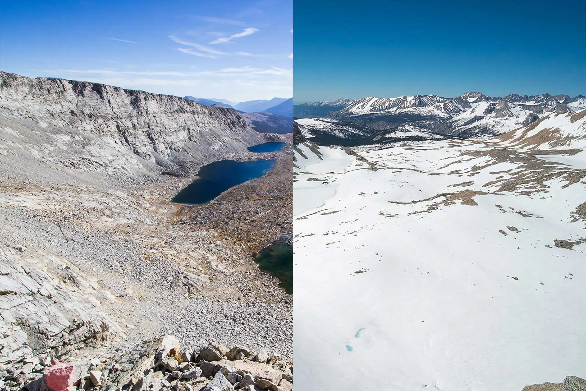
The Northern California Section of the PCT has a lot to offer, but as I said, its charms are lost on thru-hikers exiting the Sierra. However, perhaps as a section hiker, you will not suffer from the same jaded appetite as thru-hikers.
Water sources in NorCal are not as bountiful as they are in the Sierra, but they aren’t as big a problem as they are in the desert. The one place to note is Hat Creek Rim, an almost 30 mi / 48 km waterless stretch south of Burney Falls State Park (and north of Old Station in this section).
The last note is that much of the PCT in Northern California is under 5,000 ft / 1,524 m – the elevation cutoff for poison oak. Keep an eye out – especially on those long descents and ascents that bookend many NorCal towns.
Note: I was conservative on the mileage for many of these hikes and typically did not assume more than 12 mi / 19 km per day. However, if you’re looking for more of a challenge, I’ve included extensions at the end of each section so that you can conquer as much of the PCT as possible. In the event you’re saying, “That’s not conservative!” I’ve also included some ways to shave miles for most of the hikes.
For planning and navigating all of the Pacific Crest Trail section hikes listed below, I encourage you to check out FarOut Guides. They make an excellent app with waypoints, GPS functionality (even without service), distances, side trails, and more.
A Weekend: Castle Crags to Gumboot Campground
Start: Highway 5 near Castle Crags (PCT 1,498.7)
End: Gumboot Campground (1 mi / 1.6 km E of PCT 1523.3)
Length: 25 mi / 40.2 km
Elevation Gain: +6,852 ft / 2,088 m
Elevation Loss: -2,503 ft / 763 m

NOTE: The hike described here starts where the PCT crosses Highway 5, but you can also begin from the entrance to Castle Crags State Park.
This hike follows the PCT, climbing up from Highway 5 around Castle Crags and then continuing west before taking a northward turn and ending at Gumboot Campground near Gumboot Lake.
About halfway to Gumboot Campground, there’s a campsite (PCT 1516.4 – 6,320 ft / 1,926 m) with views of Castle Crags and Mt. Shasta. If you’re planning on taking two days to hike the 25 mi proposed here, this might be an excellent place to stop. There’s a spring at PCT 1513.7 (5,865 ft / 1,788 m) where you can pull water for the night.

The hike’s climbing maxes out near the Seven Lakes trail junction (PCT 1521 – 6,767 ft / 2,063 m), where you can head down to Echo Lake in the Seven Lakes Basin (this would be a nice place to camp if you can make it this far for an out and back).
You can also try your luck at summiting Boulder Peak via a cross-country trip from Tamarack Lake. This might be a nice way to tack on a bit of extra hiking if your destination is Gumboot Campground, but you feel that 25 mi / 40.2 km isn’t enough for your weekend adventure.
Alternates
Ideally, you would be either picked up and dropped off for this hike or have a vehicle waiting for you at the other end. However, if that is not possible, then you can just turn this into an out-and-back beginning at the entrance to Castle Crags State Park (or crush the 25 miles / 40 km to Gumboot and then head back the next day). To add something fun to this out and back, you could also opt to hike another 4.5 mi / 7.2 km round trip to the base of Castle Dome and over to Indian Springs. This can be done via a spur trail at PCT 1501.2 (2,828 ft / 862 m).
There are a few alternates you can do with this hike to mix up the scenery a little if you decide to turn this into an out-and-back (check out the Flume Trail and the Dog Trail).
Extension
If you want to extend this, you can also plan your exit (or entrance) when the PCT crosses Parks Creek Road (PCT 1537.2 – 6,860 ft / 2,091 m) or Highway 3 at Scott Mountain (PCT 1557.7 – 5,407 ft / 1,648 m).
Four or Five Days: Belden to Drakesbad Guest Ranch
Start: Belden (PCT 1,284.3)
End: Drakesbad Guest Ranch (PCT 1,347.6)
Length: 63.3 mi / 101.8 km
Elevation Gain: +12,749 ft / 3,886 m
Elevation Loss: -9,320 ft / 2,841 m

The town of Belden has an interesting reputation on the PCT and is famous for its yearly music festival (held in August). Linger here if you’re interested in meeting some characters, or set off and get ready for a serious lesson in climbing.
Leaving Belden, you begin immediately climbing and get to experience the source of a lot of PCT thru-hiker complaining. The first 14.2 mi / 22.8 km is mostly uphill as you climb 6,052 ft / 1,845 m (with 1,173 ft / 378 m of descent).
There should be plenty of water on the trail for the first 10 mi / 16 km in case you want to lighten your load for the climb by cutting down your water carry.
After 36.4 mi / 58.6 km, just after crossing the midpoint of this hike, you will reach the midpoint marker of the Pacific Crest Trail (PCT 1,320.7 – 7,229 ft / 2,203 m). Although the midpoint of the PCT has moved a couple of times (and the actual midpoint may be something more like PCT 1,325.1 – 4.4 mi / 7.1 km north of the actual marker), you will be passing it in this area.
Yes, a lot of the PCT is in California.

Not long after the midpoint marker, the trail passes Highway 36 (PCT 1,328.8 – 5,051 ft / 1,528 m). The town of Chester sits 7.5 mi / 12.1 km east of here, and if you’ve decided to give up on your hike, then this is just the place to do it).
The trail climbs up from the highway and now makes its way toward the Lassen Volcanic National Park boundary (PCT 1,343.8 – 5,909 ft / 1,801 m).>\@?
There are some trails around here that you can explore if you’re not ready to wrap up your hike and aren’t in the mood for a long extension. Drakesbad Guest Ranch (the northern terminus of this hike) is just another 2.8 mi / 4.5 km away. Drakesbad (PCT 1,347.6 – 5,700 ft / 1,737 m) has coin laundry, showers, and a restaurant. It is accessible via a paved road (private vehicles permitted).
Drakesbad phone: +1 866-999-0914
Drakesbad website: http://www.drakesbad.com
Extension
You can get in another 23.3 mi / 37.5 km by continuing north to Old Station (PCT 1,370.9).
This small town, just 0.3 mi / 500 m west of the PCT, has a small store, motel, payphone, RV Park, and post office.
Beyond Old Station is the (PCT) famous Hat Creek Rim, an almost 30 mi / 48 km waterless stretch that leads to the town of Burney and Burney Falls State Park.
A Week: Castle Crags to Etna
Start: Highway 5 near Castle Crags (PCT 1,498.7)
End: Etna Summit (PCT 1597.2)
Length: 98.54 mi / 158.6 km
Elevation Gain: +17,595 ft / 5,363 m
Elevation Loss: -13,772 ft / 4,198 m
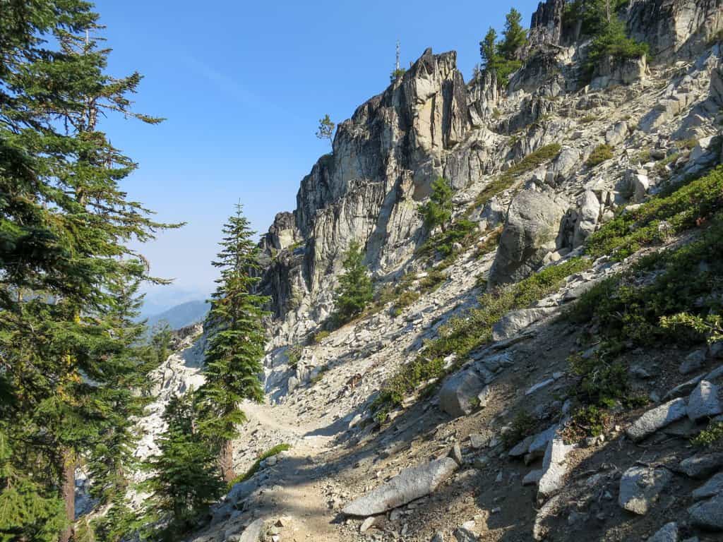
This trail, in addition to passing through Castle Crags State Park, hits two of the big-name wilderness areas in Northern California: the Trinity Alps Wilderness and the Russian Wilderness.
You can also begin this hike from the entrance to Castle Crags State Park or one of several side trails that head up to meet the PCT in Castle Crags (the Flume Trail or the Dog Trail, to name a couple).
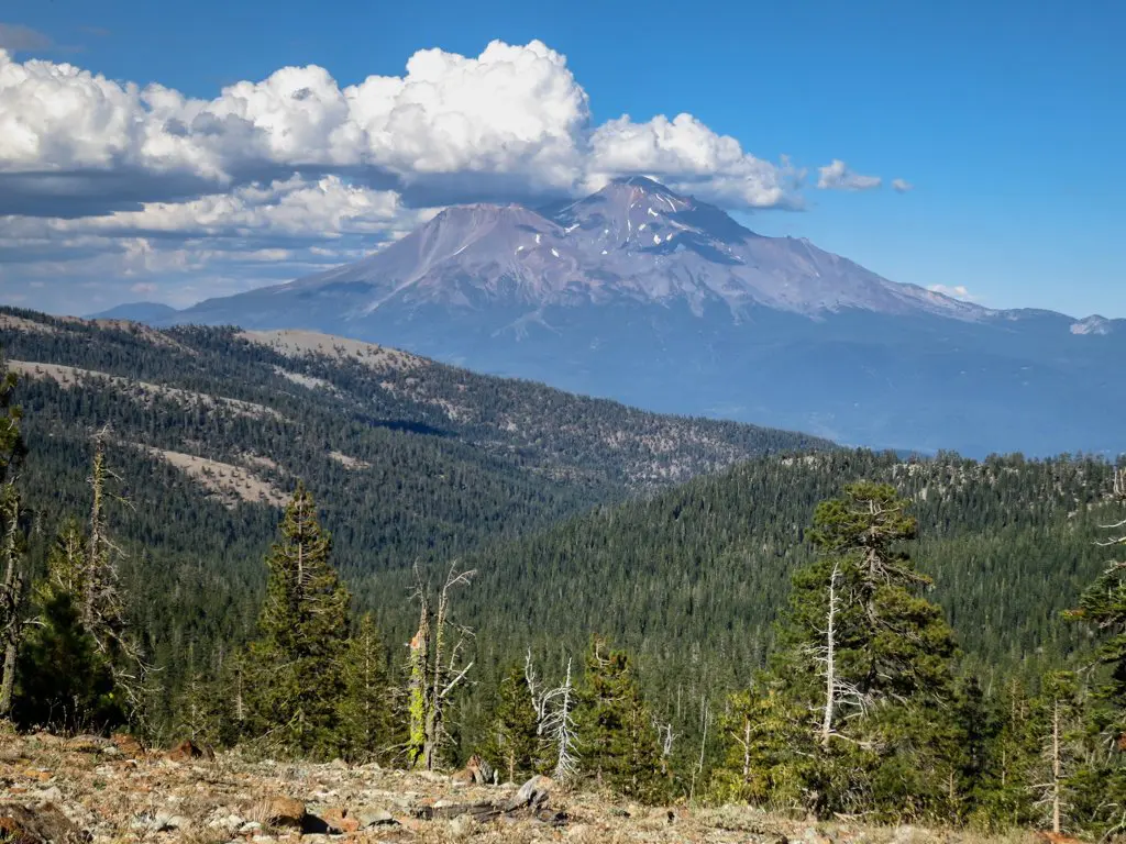
Hiking up into Castle Crags, you will quickly be rewarded with views of Mt. Shasta rising up in the north. If you want to detour, you can also hike a 4.5 mi / 7.2 km round-trip spur to the base of Castle Dome and over to Indian Springs if you think you’ll have time.
Leaving Castle Crags, you’ll encounter a bit of a climb (around 3,500 ft / 1,067 m), but the trail eventually mellows out. With the exception of a few small climbs and descents, the trail through this section is surprisingly level for what hikers generally come to expect on the PCT.
Water isn’t an issue in this section, but it isn’t incredibly abundant either. Make sure you’re filling up and keeping in mind where your water sources are (or risk becoming another corpse on the PCT).
After passing Highway 3 at Scott Mountain (PCT 1,557.7 – 5,407 ft / 1,648 m), the trail enters the Trinity Alps Wilderness (PCT 1,560.3 – 6,382 ft / 1,945 m). Exiting the Trinity Alps, the trail passes Highway 93 at Carter Meadows Summit (PCT 1,577.6 – 6,178 ft / 1,883 m) and then enters the Russian Wilderness (PCT 1,583.6 – 7,148 ft / 2,179 m) shortly afterward.
Both Highway 3 and Highway 93 are good places to bail if you need to do so.

Once you enter the Russian Wilderness, you have another 11.6 mi / 18.7 km before reading Sawyers Bar Road at Etna Summit. The town of Etna is 10.4 mi / 16.7 km east of here (down a windy mountain road).
Extension
Is that not enough to fill a week of your time? You could try pushing all the way up to Grinder Creek Campground (PCT 1,646.9) in Seiad Valley. This will push your daily average (assuming a week-long trip) to above 20 mi / 32 km per day, so it might be best to do this if you have a bit more time.
Note: The 12.5 mi / 20.1 km after Sawyers Bar Road are dry, so make sure to carry water.
Two Weeks: Seiad Valley to Burney Falls
Start: Grinder Creek (PCT 1,646.9)
End: Burney Falls State Park (PCT 1,416.5)
Length: 230.4 mi / 370.8 km
Elevation Gain: +45,540 ft / 13,880 m
Elevation Loss: -44,312 ft / 13,506 m

I suggest doing this hike southbound on the PCT for three reasons.
First, you can easily skip the 6.4 mi / 10.3 km road walk between Seiad Valley (PCT 1,653.4) and Grinder Creek (PCT 1,646.9); second, because McArthur–Burney Falls Memorial State Park (Burney Falls) is a lot more awesome of a place to end your hike than Seiad Valley; and third, because I can.
Your hike starts with a huge climb up from Seiad (as is typical of Northern California towns along the PCT) – be sure to watch for poison oak on the way up (poison oak does not grow about 5,000 ft / 1,524 m).
There are some beautiful lakes in the valleys below as you wind your way south towards Etna Summit (PCT 1597.2). This is a good place to bail if you’ve found yourself in over your head (Etna is 10.4 mi / 16.7 km NE of the PCT).

Assuming you wish to continue, head south towards some of the best-known parts of Northern California’s PCT: the Marble Mountain Wilderness, the Russian Wilderness, and the Trinity Alps Wilderness.
After 148.2 mi / 238.5 km of hiking, the trail intersects Highway 5 (PCT 1,498.7) just after descending through Castle Crags. Here you can resupply at either Castella (2 mi / 3.2 km SW of the PCT 1498.7), Dunsmuir (a town 5.5 mi / 8.9 km N of PCT 1,498.7 on Highway 5), or Mount Shasta (13.2 mi / 21.2 km N of PCT 1,498.7 on Highway 5). Castella is the easiest of the three to reach and has Ammirati’s Market next to the post office (open daily 8-9).
Following another long climb up to the trail, you still have one more big climb to look forward to – starting at PCT 1468.5 (2,372 ft / 723 m) after crossing the large wooden bridge over the McCloud River. After this 10 mi / 16 km climb, the trail flattens out for a while (relatively, that is), before finally making its way down to Burney Falls State Park (PCT 1,416.5).
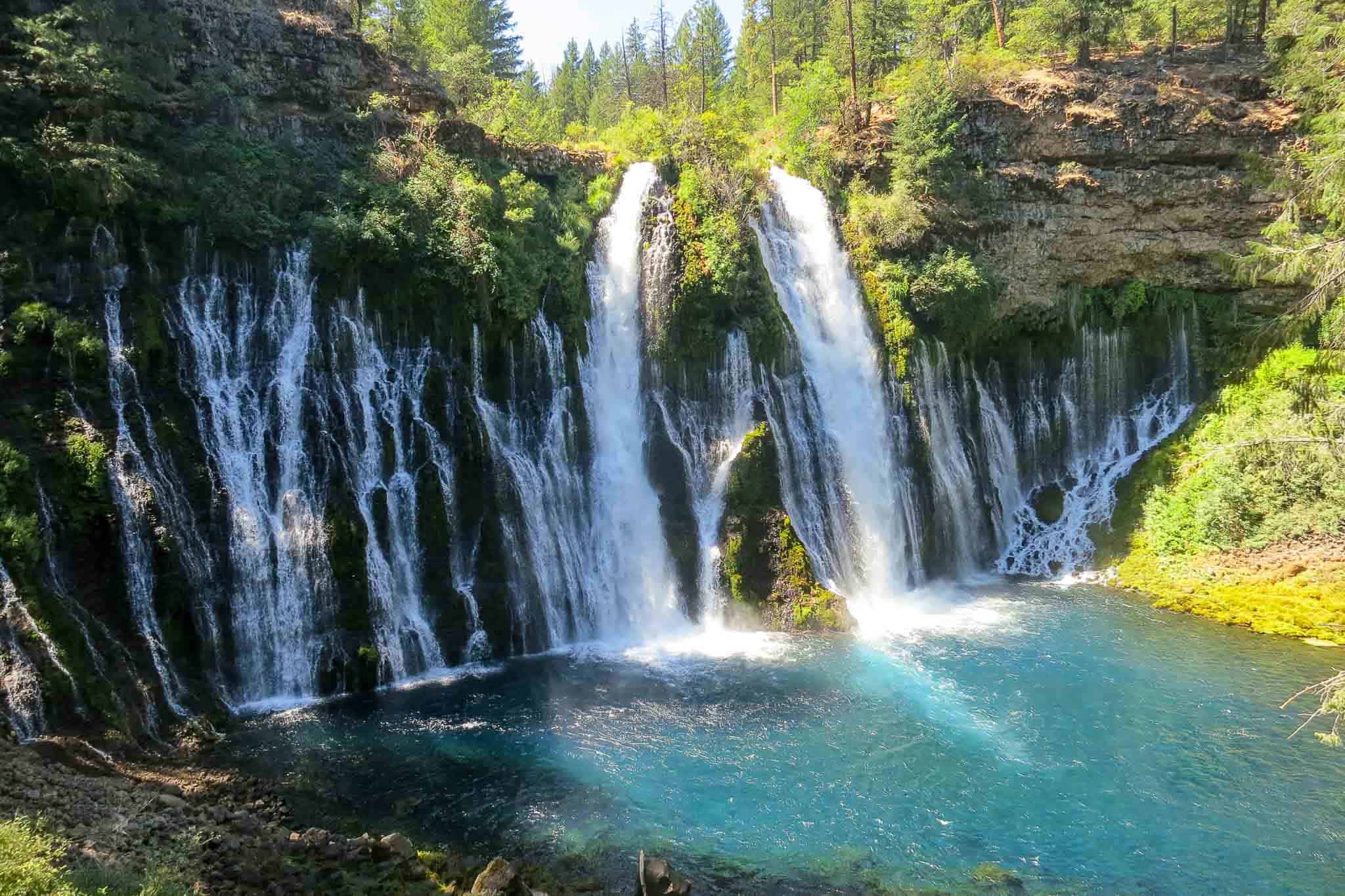
In addition to a 129-ft/39-m high waterfall, Burney Falls State Park has a store, campground, water, showers, and laundry. It’s basically a backpacker’s dream.

Short Version
Since the mileage here averages out to be 16.5 mi / 26.6 km per day (and I promised something closer to 12 mi / 19 km in the beginning) and because you’ll have to resupply during this hike, here is a suggestion for shaving some miles to complete this hike in a two-week window. Instead of starting at Grinder Creek, start your hike at Etna Summit (PCT 1,597.2) to save 56.2 mi / 90.5 km and skip this section. This drops your daily average to 12.4 mi / 20 km per day (assuming a two-week time frame).
Extension
If you want to keep hiking past Burney Falls, you will have to continue south across Hat Creek Rim another 23.3 mi / 37.5 km to Old Station.
Note: This section includes a 30-mi / 48-km waterless stretch across Hat Creek Rim, so make sure to get plenty of that waterfall juice before pressing on.


How far is it from Seven Lake Trailhead to Echo Lake?
Are permits required for the weekend Castle Crag trip? I’ve looked online but haven’t found much information other than for campground reservations, but I was thinking more of an overnight backpacking trip than camping in a campground.
I would suggest calling Castle Crags State Park. Their number is +1 (530) 235-2684
I am trying to plan a section hike around Belden, +/- 100 north. Did you have a specific permit? Or did you already have a thru-hiker permit? I have been looking online with no luck…
I had a PCT Long-distance Permit. Check out the sites for the wilderness areas that you will be traveling to. If you can’t find anything, you probably don’t need a permit.
SLIGHTLY off subject but im planning to do donner or sierra city nobo to burney falls or slightly further this summer. what do you think of those sections between donner and burney? ive heard mixed opinions.
Meh. Lassen is cool, I guess.