Canada Ends Entry Program for PCT Hikers
According to the Government of Canada, northbound Pacific Crest Trail hikers will no longer be permitted to cross the US-Canadian border at the PCT’s northern terminus. Previously, northbound PCT hikers could apply for a permit to enter Canada from the United States to continue north from the border to Manning Park in British Columbia.
Now, northbound hikers wishing to tag the PCT’s northern terminus will suffer the same fate as southbound hikers wanting to begin their hikes at the US-Canada border: they will have to hike the 40 mi / 64 km between Canada and Harts Pass (the closest road access to the northern terminus) twice.
Before this change, armed with an entry to Canada permit, northbound hikers could instead hike a relatively mellow and fairly uninteresting (beyond the fact they’re in Canada) 7.7 mi / 12.4 km from the border to Manning Park.


How will this change the logistics of a northbound thru-hike?
- It will add 32.3 mi / 52 km to a northbound PCT thru-hike (but what’s another day on top of months?)
- It will likely result in unlicensed shuttle services popping up and masquerading as trail angels at Harts Pass (no, trail angels, the hikers don’t need you).
- There will be a lot of noise from a small but vocal group of northbound thru-hikers who think they’re special (and if this sentence stings, you’re probably a part of that group).
- Hikers flying back home will likely now do so from Seattle instead of Vancouver (maybe this is all a ploy by Seattle–Tacoma International Airport to get more business?)
Will it mean people will choose to hike southbound instead of northbound? Probably not. But I wouldn’t be surprised if it changed the minds of a handful of hikers.

Ultimately, this will not significantly impact Pacific Crest Trail hikes. Was it cool to be able to hike across an international border to end a cross-country hike? Sure. Was it necessary? Nope.
That said, my heart goes out to the small number of Canadian hikers who each year finish their northbound thru-hikes by hiking back into their homeland and getting picked up by friends or family at Manning Park. The logistics of returning to Harts Pass and then reentering Canada via an official port of entry is much more of a hassle than hiking another 7.7 mi / 12.4 km to poutine and signs written in français.
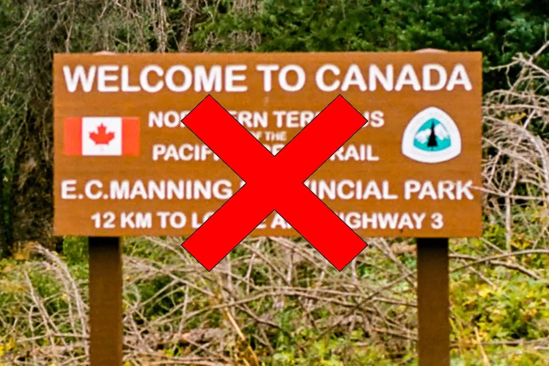
The question now is whether they will remove the “Welcome to Canada” sign since, theoretically, nobody will be welcome into Canada via the Pacific Crest Trail.
An Alternative Route
One alternative for northbound Pacific Crest Trail hikers who don’t want to return to Harts Pass is an exit via Ross Lake, west of the PCT and the northern terminus.
Here’s how to hike out to Ross Lake via the PCT:
- Hike 16.5 mi / 26.6 km south on the PCT from the border
- Turn west on the Devils Ridge Trail and follow it west for 7.9 mi / 12.7 km until it intersects with/becomes the Devils Dome Loop Trail
- Here, you have two options:
- Option 1: Turn right/continue west for another 10.2 mi / 16.4 km until it intersects the East Bank Trail and then follow the East Bank Trail south for 11.9 mi / 19.2 km until reaching Highway 20
- Option 2: Turn left/head south on the Devils Dome Loop Trail/Jackita Ridge Trail for 14.4 mi / 23.2 km until reaching Highway 20
Option one makes for 46.5 mi / 74.8 km of hiking – 6.5 mi / 10.5 km longer than the hike to Harts Pass from the northern terminus. Option two makes for a 38.8 mi / 62.4 km hike – 1.2 mi / 1.9 km shorter than the hike to Harts Pass. Both options get hikers to a more desirable place for road access (option two, a bit further east on the highway).
Highway 20 is the main road corridor through the area and is the road you would use to drive to the Seattle area. It’s far more likely to have traffic than the road at Harts Pass and will likely result in better hitchhiking opportunities (or a better pickup spot) for northbound hikers finishing their hikes.
That said, maybe northbound hikers will want to hike back to Harts Pass to get one more glimpse of their hiker friends, who may be a day or two behind them. Maybe it will inspire some PCT hikers to do the hike again – but southbound. Perhaps it will inspire a yo-yo attempt. Who knows?
If you’re looking at the map, you may spy another (slightly shorter) route via the Castle Pass Trail. However, the Okanogan Wenatchee National Forest has advised against this trail as it is not maintained and is difficult to follow. The Devils Ridge Trail route is the recommended route for reaching Highway 20.
That said, here’s what the Castle Pass Trail hike out would look like.
- Hike 3.5 mi / 5.6 km south on the PCT from the border
- Turn west on the Castle Pass Trail and follow it west for 19.3 mi / 31 km to the East Bank Trail
- Follow the East Bank Trail south for 21.1 mi / 34 km until reaching Highway 20


Yeah, I’ll bet this is mostly political……
As a NOBO in 2021, I was definitely bent out of shape when the border wasn’t open, but it turned out to be a blessing. For the last 3 days of my hike (between Hart’s Pass and Hart’s Pass, punctuated by finishing the PCT), I met hikers I had seen and hiked around for the previous 4 1/2 months. Hugs, laughs, high fives. It was great, and it wouldn’t have happened if the border had been open.
Not going to lie, that sounds pretty fun.
Another alternative would be to arrange for a water taxi to pick you up from the north east end of Ross Lake. This is a real bummer.
If you have to ask why Canada just closed its border, you haven’t been paying attention.
Funny you’d say exactly what I was thinking as I read the article… I wasn’t going to go there but since you put it out there …
And, Mac, you are appreciated as is the knowledge, and honesty you share – Thank You…
Ah, that’s too bad! In 2019 I walked to Manning. PCTers got a free donut and gym access. A shower and steam room!
Gym access – what every PCT hiker dreams of at the end of their thru-hike.
Why? The Canadians don’t seem to have a problem with people coming south across the border.
Would that be people disembarking boats after crossing the Arctic Ocean?
Why would they? Coming south is a US issue. The US has never allowed that as far as I know.
Turn about is fair play.
This article feels incomplete, given that it doesn’t state what Canada’s reason is for ending the entry permits. That’s an obvious question people would want to know the answer to, so if the reason for its omission is that the author doesn’t know, I hope there will be an update when the reason is out. It would suck if they left useful info out just to “remain apolitical” or whatever. If the info affects hikers, it’s not just politics.
Knowing the reasoning would also help hikers determine what this might mean for the CDT and Waterton terminus.
The Government of Canada’s website does not currently provide any reason for this.
Also, the situation on the CDT is entirely different as there is a ranger station/border crossing procedure in place at Goat Haunt, where the CDT hits the US-Canada border.
More on that at the following links:
https://www.canada.ca/en/parks-canada/news/2023/06/waterton-glacier-announce-reopening-of-goat-haunt.html
https://www.nps.gov/glac/planyourvisit/goathaunt.htm
Goat Haunt is not a full, staffed port of entry. If you’re entering Canada, you have to call in and self-report your entry. So if, for example, the Canadian Border Patrol’s reason for not allowing PCT hikers to cross was related to not wanting to staff phones, or not wanting to allow entry where you don’t get screened in person by an actual agent, that would indicate possible upcoming policy changes for going north into Waterton as well. That’s why knowing the reason for the PCT change is important.
I look forward to the results of your rigorous investigation.
Maybe worth mentioning the possible hike out via Ross Lake, which has you ending up at Highway 20 for a more convenient pick up
Good call! Added.
I was there late September 2024. It appeared that most hikers returned from the border back to Harts Pass. A few hikers had permits, and a small number had applied for permits, but the permits never arrived. My opinion is that the PCT has grown so popular that it is too much of a problem for the Canadian government to process all the requests, especially now that Trump is breathing down their throats about border security and tariffs.
The simplest explanation would be that it’s a relatively simple cost-cutting measure.
No, it opened back up mid 23.
I encourage you to check the Government of Canada website cited at the top of the article: https://www.cbsa-asfc.gc.ca/travel-voyage/pecpct-eng.html
In 1997 our group of 6 just hiked on thru to Manning Park, no permit, no problem. Two of our wives picked us up and we gorged on pizza and beer in Hope. Then we crossed the border in Sumas all loud, drunk, and stinky. Welcome back to the USA!!!
Just think, you could have been this group of six: https://nationalpost.com/news/canada/migrants-caught-illegally-crossing-border-manitoba
Still haven’t heard a good reason why they closed the border. Years back, I crossed the border with all the necessary Canadian permits. Had a great experience.
Serious question: what would you consider a good reason?
Why wouldn’t Canadian citizens be allowed to cross there?
Because their government says so.