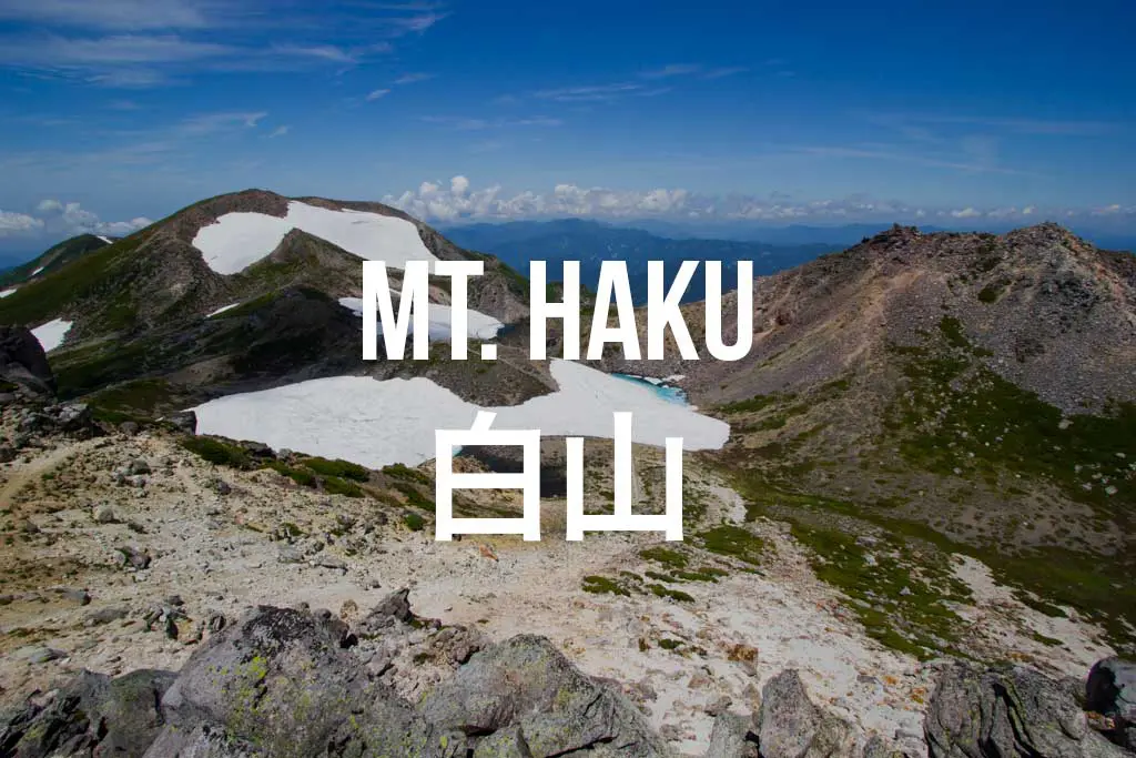
Hiking Mount Haku (白山) in Japan
Mount Haku (白山, Hakusan) is one of Japan’s Three Holy Mountains (三霊山) along with Mount Tate and Mount Fuji (what that means, I have no idea).
The mountain is on the border of Gifu (岐阜), Fukui (福井), and Ishikawa (石川) prefectures in Japan’s Hokuriku Region (北陸地方). Ishikawa is home to the most popular trailhead, but the peak can be approached from Gifu and Fukui as well (although these require multi-day hikes – approaching from Mount Sannomine in Fukui via Mount Bessan is one option).
Hakusan Facts
- Name: Mount Haku
- Japanese name: 白山 (Hakusan)
- Location: Hokuriku (北陸地方)
- Summit elevation: 8,865 ft / 2,702.2 m
- Elevation change: 4,764 ft / 1,452 m
- Round-trip distance from trailhead: 10.6 mi / 17 km (following the route here)
- Round-trip time from trailhead*: 8 hours (following the route here)
- Difficulty: Strenuous
- Water on trail: Available at Murodo (the massive lodge just below the summit)
- Trailhead facilities: Parking, bathroom, lodge, drinks, food
- Nihon Hyaku-meizan: Yes
- Note: One of Japan’s Three Holy Mountains (三霊山)
*NOTE: The round-trip time listed above is based on my own experience. Please remember that your time may vary greatly.
Getting to Hakusan
- Accessible via public transportation: Yes
- Trailhead parking: Yes
- Trailhead coordinates: 36.114304, 136.700530
- Summit coordinates: 36.155010, 136.771312
BY CAR: Via car, the base of Mount Haku can be reached easily. However, if you are heading up during peak season the road to Bettodeai (別当出合), home to the most popular trailhead, is closed to private traffic (weekends and holidays from mid-July to mid-October) – more on this in a second. If the road is closed (or you want a longer, more challenging hike), you can use a free parking lot at Ichinose Campground (市ノ瀬野営場) – map. From here you have two options:
- Hop on the bus for ¥500 and take it up to Bettodeai (別当出合). This will shorten the length of your hike to the summit by approximately five to six hours (according to the map).
- Park and walk up the road (or over the bridge spanning the stream at the northwest corner of the parking area – both routes will lead to the same place) until you reach the Hakusan Zenjodo Route (also called the Old Echizen Zenjodo Route). Follow this (and the signs) to Murodo (室堂).


BY TRAIN: There aren’t any train stations near the trailhead, so your best bet may be to head to Kanazawa Station (金沢) or Tsurugi Station (鶴来) and catch the bus to Bettodeai (別当出合) (described below).
BY BUS: You can reach the trailhead via bus from either Kanazawa Station’s (金沢) bus stop 1 (out the east exit of the station) or Tsurugi Station (鶴来) – the fares and times are ¥2,200/130 minutes and ¥1,700/100 minutes respectively. From either station, take the bus bound for Bettodeai (別当出合).
For more information on buses, you can check the schedule here (Japanese only).
The Hike
There are two main trails leading up to the summit: the (far) more popular route begins at Bettodeai at 4,134 ft / 1,260 m, and the less-traveled route (the one described here) begins at the Ichinose Campground (市ノ瀬野営場) at 2,738 ft / 834 m where you probably parked (if you have one of those automobiles).
Just so you don’t get confused if you happen to be reading this entire report: I began my hike at the Ichinose Campground, followed the Old Echizen Zenjodo Route up until it turned into the Kanko Shindo Route, and then followed this trail up to Murodo and the summit. On the way down I took the Saboshindo Route past the Junnosuke Shelter and down to Bettodeai where I caught the bus back to the Ichinose Campground. Got it? Good.
For a clean and labeled cartoon map of the area click here. Note: The Ichinose Campground and the bottom half of the Old Echizen Zenjodo Trail are not pictured on this map.


From the parking lot at Ichinose, either follow the road up or find the bridge spanning the stream at the northeast corner of the parking area (either way will get you to the same place). Head up the road until you reach a sign for the Hakusan Zenjodo Route (also called the Old Echizen Zenjodo Route).
Follow this trail and make sure you pay attention to the signage at the junctions you reach; all of them are clearly marked and have signage with landmarks and distances(in English and Japanese).
The trail does a lot of up and a little down as you make your way towards Mount Haku (which you will get a few glimpses of as you cross some smaller peaks along the way. Continue through the sometimes overgrown, but easy-to-follow trail and you will soon find yourself out of the undergrowth and with views back into the valley and of the surrounding mountains (or clouds and fog).
Not long after you begin up out of the trees, the trail passes a junction for Bettodeai. Past this junction, this trail is called the Kankou Shindou Route (観光新道), and it is still another four to five hours to the summit. If you need to bail for whatever reason, it takes about an hour to reach Bettodeai from here via the intersecting trail (from there you can take a bus back to Ichinose).

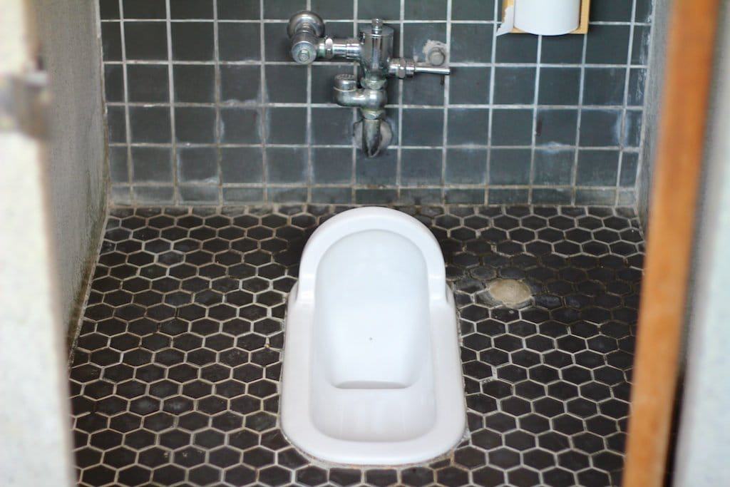
Continue 1.2 mi / 2 km past the junction and you will reach the (at the time of writing this) new and surprisingly nice-looking Tonogaike Shelter. Here you can find a squat toilet (because you’ve entered the trail’s crowded area) and probably a ton of other hikers if you’ve chosen a nice day for your hike
Thirty minutes after leaving the shelter (and 5 mi / 8.1 km from the trailhead if you’ve followed this route), the trail comes to a junction with the Saboshindo Route (which is the trail I followed on the way down) before continuing another .6 mi / .9 km and 328 ft / 100 m up towards Murodo. Past this, you will find yourself on a surprisingly flat area with a boardwalk-esque trail to escort you to your next climb.
Murodo (室堂) – the massive lodge 8,038 ft / 2,450 m up with a drying room, flushing toilets, and enough space for 750 guests – awaits you after this climb (typically open May 1 to October 15). And if you brought any mail with you, then you are in luck – there is a post office, too. If you want to find out more about Murodo or for some reason have been compelled to make a reservation to stay the night there (and you speak Japanese), you can visit their website.


The Summit
From Murodo it takes around half an hour to reach the summit of Mount Haku’s tallest peak, Gozengamine (御前峰) at 8,865 ft / 2,702.2 m (via the middle – and probably most obvious – of the three trails leading towards the summit area). Warning: For anyone looking at the track I recorded (below), know that I am fairly certain that my return trip to Murodo (the more western track) was done mostly off-trail (accidentally).
The summit area is a good size and is home to a Shinto shrine (because no Japanese mountain is complete without one) and a number of volcanic lakes.
From here you can retrace your steps back to Murodo or head over to do a loop of Mount Haku’s two other peaks, Kengamine (剣ヶ峰) at 8,783 ft / 2,677 m and Ōnanjimine (大汝峰) at 8,688 ft / 2,648 m. A loop takes about an hour and will take you back to Murodo.


If you are like me and you don’t feel that hiking all the way back down to Ichinose Campground is how you want to end your day, you can change up the scenery (and shave some time off your return hike) by instead heading down to Bettodeai (別当出合).
On the way down, when you reach the junction of the Kankoshindo Route (the one you hiked up if you’ve been following the hike described here) and the Saboshindo Route, follow the Saboshindo Route down past the Junnosuke Shelter Hut (6,647 ft / 1,965 m), Bettonozoki (5,741 ft / 1,750 m), and Nakahanba (4,921 ft / 1,500 m) to Bettodeai (4,134 ft / 1,260 m).
Just follow the signs and know that this way down will likely be far more crowded than the Old Echizen Zenjodo and Kankoshindo routes described here for the climb up.

Map of Hakusan
The following was the route my GPS recorded on my hike up Mount Haku.
I have no guarantee that this route is correct, nor that it can be accurately relied upon for backcountry navigation. It should serve only as a general guideline for what the trail is expected to look like.

Conclusion
If you find yourself in the area (or are willing to travel) Mount Haku is a great option for a challenging day hike (or possible multi-day hike – camping is permitted at Nanryusanso Lodge).
Although many of the views and peaks offered in the nearby Kita Alps are far more dramatic than Hakusan, none of them are one of Japan’s Three Holy Mountains (except of course Tateyama). And no, I still have no idea what it means to be one of these three mountains (but I am sure it has to do with these particular mountains being worshiped by people many centuries ago).
To check out the official website of Hakusan National Park (that is, not surprisingly, missing a lot of information for us English speakers), you can find it here.
Have any questions about Mount Haku? Want another post about another one of Japan’s mountains? Have a suggestion to improve this information?
Leave a comment and let me know!


Do these trails up / down Hakusan close over winter?
They’re closed in the sense that there are no services, people will tell you they are closed, and the trails will be buried in snow, but if you’re trying to do some winter mountaineering, I don’t believe there are any regulations preventing you from doing so.
Hello! I’m visiting Tokyo on a work trip. Can I do this hike on a weekend by myself?
It’s a long way from Tokyo. You could do it, but I’d recommend something closer (in the Minami Alps).
Hi there, I chanced upon this article while searching on Hakusan. I’m visiting the area in April (mainly for sakura) and thinking of doing some hiking as well. I’m wondering if Hakusan can be hiked in early/mid-April? Would it still be mainly covered by snow and is there any bus access to/from the trail head in April? I can’t seem to find much information on the hike.
Also, I would still consider myself as a beginner at this, with my toughest hikes being only Japan’s Mt. Fuji and Poland’s Tatra Mountain Five Lake hike. Is it too risky (not recommended) for me to this hike in April? Hope to hear from you soon, thank you!
Mount Haku will almost certainly still be covered in snow in April. If you’re not experienced climbing in these conditions, I would recommend looking for something further south (and at a lower elevation) for an April hike. Enjoy Japan!