Guide to Hiking Yakedake (焼岳) in Japan
Yakedake (焼岳) is an 8,054 ft / 2,455 m peak at the southern end of Japan’s Northern/Kita Alps (北アルプス). It’s also an active volcano. You can also hike to the top of it.
One of Japan’s hyaku-meizan, it’s a fairly well-known peak but is not nearly as popular a hike as some of the more prominent peaks in the area. That said, it’s easily accomplished in a day, but there are also two huts on the north side where you can stay the night if you are so inclined.
There are four trailheads for Yakedake – one along Route 158 near Nakanoyu Onsen in Nagano Prefecture (just east of the border with Gifu Prefecture), one via the Shinhotaka Ropeway in Shinhotaka Onsen (新穂高温泉), one just south of Shinhotaka Ropeway, and one via Kamikochi (上高地) – a popular gateway to the Kita Alps accessible only via bus (no private cars allowed).

Yakedake Basics
- Name: Yakedake (Mount Yake)
- Japanese name: 焼岳
- Location: Northern Alps/Kita Alps (北アルプス)
- Summit elevation: 8,054 ft / 2,455 m
- Roundtrip distance*: ~10.2 mi / 16.4 km
- Elevation Change*: ~2,080 ft / 634 m
- Difficulty: Easy-Moderate
- Water on the trail: Yes**
- Trailhead facilities: Parking, bathroom**, lodge**, drinks**, food**
- Nihon Hyaku-meizan: Yes
*This is the distance and elevation change from the Shinhotaka Onsen trailhead (more on the others below)
**These facilities are only available if hiking from Shinhotaka Onsen or Kamikochi (more on this in the next section)

Getting to Yakedake
There are four trailheads for Yakedake: one at Kamikochi (上高地), one at Shinhotaka Onsen (新穂高温泉), one just south of Shinhotaka Onsen, and one on Route 158 near Nakanoyu Onsen (中の湯温).
- Accessible via public transportation: Kamikochi and Shinhotaka Onsen
- Trailhead parking: Shinhotaka Onsen and Route 158
- Trailhead coordinates:
Route 158 (36.203934, 137.598908)
Shinhotaka Onsen* (36.285816, 137.575336)
South of Shinhotaka Onsen (36.257405, 137.574757)
Kamikochi (36.231729, 137.620956) - Summit coordinates: 36.227021, 137.586984
BY TRAIN
There is no train access to any trailhead.
BY CAR TO SHINHOTAKA ONSEN*
There is a free parking lot for hikers at the Ryokan Shinhotaka Okuhida (map). From here, you will need to walk up the road, past the entrance to the ropeway, and then past the parking lot at the top of the hill to officially begin the hike (signage and maps provided at the lodge).
BY BUS TO SHINHOTAKA ONSEN*
From Takayama Station (高山駅) in Gifu (it’s a train station) take the bus bound for Shinhotaka Onsen (新穂高温泉) to the last stop. It takes about an hour and a half. The first bus departs Takayama Station at 7:00 in the morning.
You can also take a bus from Matsumoto Station (松本駅) in Nagano if you’re farther north.
*The Shinhotaka Onsen hike requires you to take the Shinhotaka Ropeway up and back from the trail. This saves a significant amount of elevation gain. For costs and hours, check here.
BY CAR TO SOUTH OF SHINHOTAKA ONSEN
If you don’t want to take the ropeway and would prefer to hike up from south of Shinhotaka Onsen, there is another trailhead on the way there, located at 36.257405, 137.574757. You can park here or walk from Shinhotaka Onsen (see directions for Shinhotaka Onsen above).
BY CAR TO ROUTE 158
There is a turnout on Route 158, where maybe 20 to 30 cars could fit. It is free and unmetered parking. The location is here 36.203934, 137.598908.
BY CAR/BUS TO KAMIKOCHI (上高地)
No private vehicles are allowed on the road to Kamikochi, so you must take a bus in. To reach the Kamikochi bus terminal, you can take a private vehicle or several different buses. Direct buses are available from Tokyo, Kyoto, Osaka, and Nagano. You can also take buses (with transfers) from Matsumoto and Takayama. For more on getting to Kamikochi, check out the official site here.
SHINHOTAKA ONSEN PARKING
ROUTE 158 PARKING
SHINHOTAKA SOUTH PARKING
Notes on Yakedake
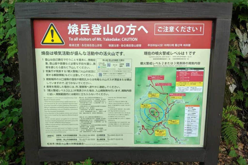
- Remember that Yakedake is an active volcano and that depending on the mountain’s temperament and the winds, climbing may be impossible due to gases from the crater.
- There are four ways to reach the summit of Yakedake. If you want to do it as a day hike and have your own car, I suggest hiking from Route 158. If you want to hit the onsen afterward, you could do a loop via the two Shinhotaka Onsen trailheads, and if you want to take the shortest route and/or go what’s probably the most popular way, go via Kamikochi.
- There are two huts north of Yakedake – Yakedake-goya (焼岳小屋), aka Yakedake Hut, and Nishiho-sanso (西穂山荘), aka the Nishiho Hut. Only hikers entering/exiting from the Shinhotaka Ropeway will pass Nishiho Hut (西穂山荘). Hikers entering from all trailheads except Route 158 will pass Yakedake Hut.
Yakedake Trail
From Shinhotaka Ropeway
This is probably the least popular route up Yakedake since it requires you to take the Shinhotaka Ropeway up to the ridgeline just south of Nishihotakadake (西穂高岳) – the peak most people hike from the ropeway. That said, it’s also the route with the smallest elevation change.
From Nishiho-sanso (西穂山荘), aka the Nishiho Hut, follow the signs (and ridge) south toward Yakedake. The trail is a bit overgrown as you pass Warudaniyama (割谷山) on your way toward Yakedake-goya (焼岳小屋), aka Yakedake Hut.
The hut has a toilet, lodging, and food and water available for purchase. From Yakedake Hut it’s 1 mi / 1.6 km of treeless hiking to the summit. You will pass some gas-spouting vents with sulfur-stained rocks and have a small bit of scrambling before reaching the summit.
Roundtrip from Shinhotaka Ropeway: ~10.2 mi / 16.4 km with ~2,080 ft / 634 m of elevation change


From Shinhotaka South
I haven’t personally hiked this way, but there is an additional trailhead south of the Shinhotaka Ropeway (parking here). This trailhead is located at approximately 4,100 ft / 1,250 m and has the most elevation change of any of the four trailheads as you climb to the 8,054 ft / 2,455 m peak.
The trail meets up with the trail from Shinhotaka Ropeway and the trail from Kamikochi at Yakedake-goya (焼岳小屋). But just before the trail splits – the trail to the left takes you directly to the hut whereas the trail to the right bypasses the hut and heads straight for Yakedake (meeting up with the trail from the hut shortly after diverging).
Roundtrip from Shinhotaka South: ~6 mi / 9.66 km with ~3,954 ft / 1,205 m of elevation change


From Kamikochi (上高地)
The trail via Kamikochi is perhaps the most popular route up to Yakedake. It begins just north of the Taisho-ike bus stop (or just southwest of the Kamikochi Imperial Hotel (上高地帝国ホテル). The trail gets progressively steeper until reaching Yakedake-goya (焼岳小屋) and then continuing up via the same route up the northern slopes of Yakedake.
Roundtrip from Kamikochi: ~5 mi / 8.05 km with ~3,133 ft / 955 m of elevation change


From Route 158
This is your trailhead for a straightforward hike up and down to the summit. The trail starts on what’s basically the side of the road and then climbs through some dense forest before breaking free of the shrub and continuing up the southern slopes of Yakedake to the summit.
There are no facilities or water along this route – you do not pass any mountain huts. Yakedake-goya (焼岳小屋), where you can find food and water for sale, is located approximately 1 mi / 1.6 km north of the summit (that’s an additional 1 mi / 1.6 km away from Route 158).
Roundtrip from Route 158: ~5 mi / 8.05 km with ~2,230 ft / 680 m of elevation change


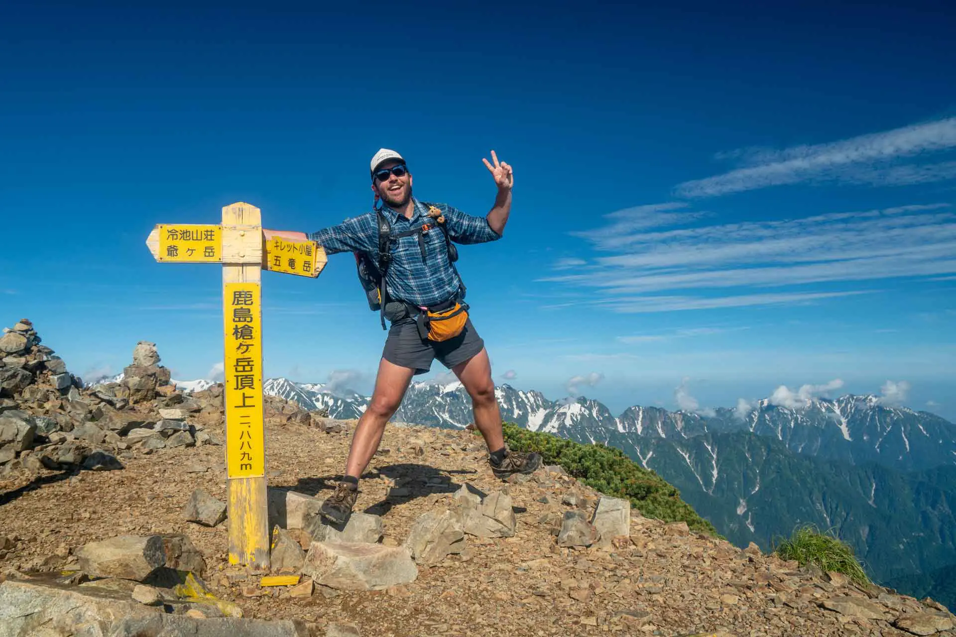
Yakedake Summit
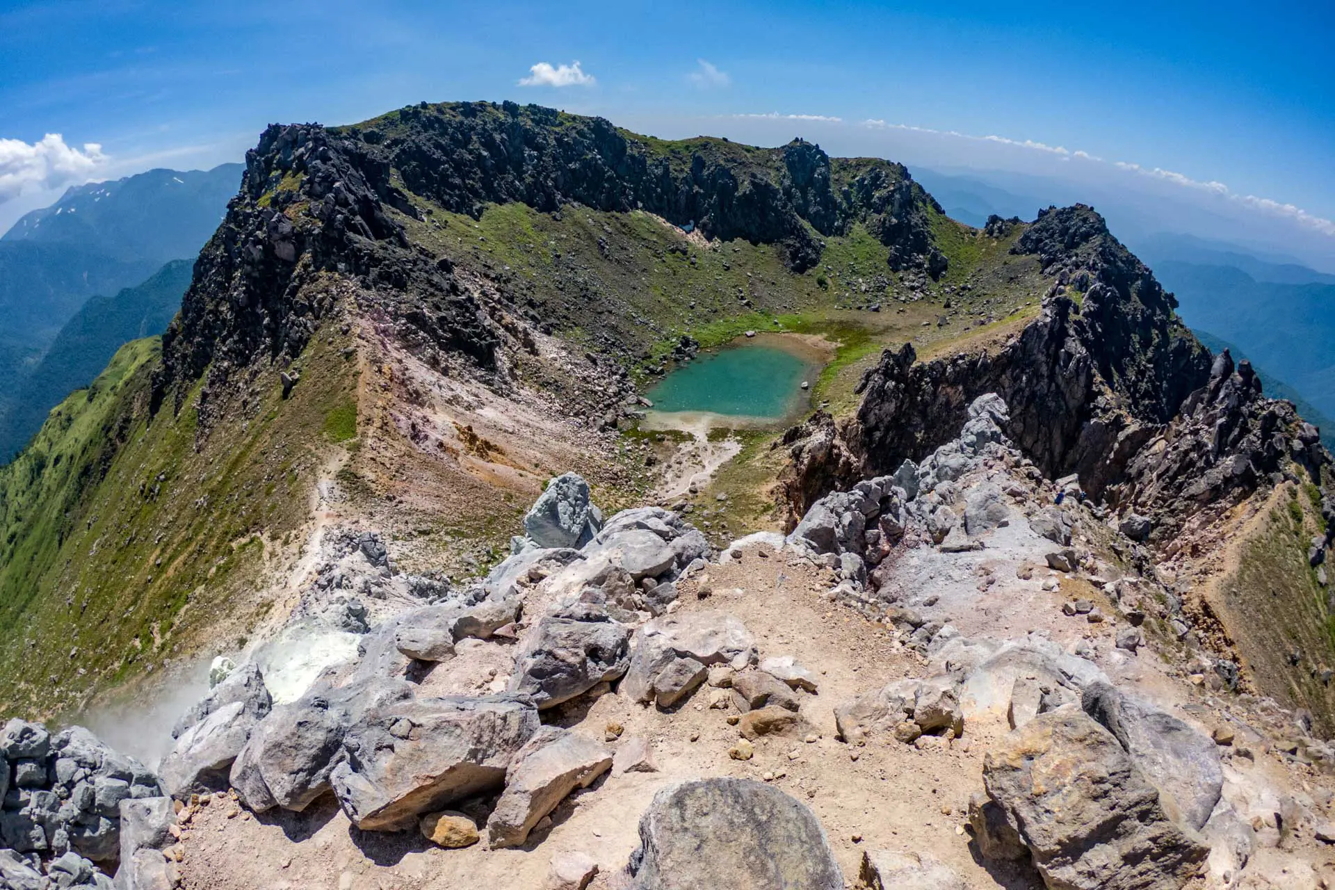
There’s a crater at the summit of Yakedake, which means that you’re not hiking toward a traditional-looking peak and instead will find the summit marker located on the southeast portion of the crater rim (don’t worry, the trail goes directly to it).
In the crater, there’s a small (probably poisonous) lake. You can scramble down a bit closer to it (and a sharp drop off), but there isn’t much in the way of a trail leading anywhere else around the crater rim. The summit marker isn’t even at the highest point of the rim – very disappointing.


Yakedake Map
The following map shows the hike up to the summit of Yakedake from the trailhead at the top of Shinhotaka Ropeway and then down to the trailhead located on Route 158.
I have no guarantee that this route is correct or can be accurately relied upon for backcountry navigation. It should serve only as a general guideline for the trail.

Wrap Up
Yakedake isn’t my favorite hike in the Kita Alps (北アルプス), but it’s one of the Nihon hyaku-meizan and it’s an active volcano. If you like to check boxes, this might be the hike for you.
Personally, I would recommend this hike via the Route 158 trailhead or as a loop via the two trailheads at Shinhotaka Onsen. Kamikochi is the easiest place to reach if you’re only in Japan for a short time and want to be efficient with your mountain exploring.
Have questions about hiking Yakedake? Want another post about another one of Japan’s mountains? Have a suggestion to improve this information? Leave a comment and let me know!
Yakedake Resources
- Kamikochi website
- Kita Alps website
- Shinhotaka Ropeway
- Shinhotaka Ropeway Schedule and Prices
- Shinhotaka Onsen
- Nishiho Hut (Japanese)
- Yakedake Hut (Japanese)
- Multilingual pamphlet with Kita Alps maps and descriptions


I intent to do a day hike and would like know is Yakedake is open for hiking during the 1st week of Nov?
None of the huts will be open at that time of the year (at least, I don’t think they will be), but you can still hike (although, depending on the year, there might be snow).
Would like to do this around 8-9th of May in 2024, however I find it hard to find information regarding when Yakedake opens up for the season, do you know?
You can see here https://www.m-kamikouchi.jp/en/yakedake/index.html
It says it opens “early June”
Planning to campervan in Gifu, route 158 seems like the best option.
Noticed that the Yakedake Hut sells some souvenirs but there’s this steep climb with ladders to get there… Concern about the ladders… as we are completely new to hiking anything more than 200m hahaha.
Are the souvenirs worth it? or are ladders completely safe?
The ladders are safe by my measure, but that could be different than yours. I believe there’s only one short ladder on the normal route to the summit hut and that the remainder of the ladders are reaching the summit (after the hut).
That said, if you’re just hiking up to get souvenirs, I would say it’s not worth it.
Hi I’d like to know if need to wear helmet while hiking in Mount Yake?
I did not wear a helmet hiking Mount Yake but many people do. It’s a personal decision.