• Skip to primary navigation
  • Skip to main content
  • Skip to primary sidebar
  • Skip to footer
Halfway Anywhere

Halfway Anywhere

  • About
  • Blog
  • PCT
  • CDT
  • Hikes
    • Arizona
      • Arizona Trail
      • Buckskin Gulch/Paria Canyon
      • Royal Arch Loop
    • Australia
      • Outback Bicycle Tour
      • New South Wales
        • The Coast Track
      • Tasmania
        • Federation Peak
        • Frenchmans Cap
        • Mount Anne Circuit
        • Overland Track
        • Western Arthurs Traverse
    • California
      • Cactus to Clouds
      • Kings Canyon High Basin Route
      • Southern Sierra High Route
      • Trans-Catalina Trail
    • Brazil
    • Japan
      • Alps Traverse
      • Fuji Area
      • Hokkaido
      • Hokuriku
      • Kansai
      • Kita Alps
      • Kyushu
    • Nepal
      • Everest Base Camp
      • Three Passes Trek
    • New Zealand
      • Ball Pass Route
    • Oregon
      • Timberline Trail
    • Washington
      • Wonderland Trail
  • Gear
    • Current Gear List
    • Gear Reviews
    • Gear Lists
    • PCT Gear
    • Best Backpacking Quilts
    • Best Satellite Messengers
    • Best Sun Hoodies
    • Best Thru-Hiking Shoes
    • Best Thru-Hiking Socks
    • Deals & Discounts
  • Surveys
    • PCT Survey
      • PCT Survey Results
      • PCT Gear Guide
      • PCT Resupply Guide
      • Women’s Gear Guide
      • Couples’ Gear Guide
      • Demographic Breakdown
      • PCT Horror Stories
      • PCT Hiker Advice
      • PCT Social Issues
      • All PCT Survey Articles
      • PCT SURVEY SIGNUP!
    • CDT Survey
      • CDT Survey Results
      • CDT Gear Guide
      • CDT Resupply Guide
      • CDT Horror Stories
      • CDT Hiker Advice
      • All CDT Survey Articles
      • CDT SURVEY SIGNUP!
    • JMT Survey
      • JMT Survey Results
      • All JMT Survey Articles
      • JMT SURVEY SIGNUP!
  • Contact
    • Say Hello!
    • Support

Japan Traverse in Photos: The Kita Alps (北アルプス)

By Mac 2 Comments

My traverse of the Japanese Alps began at the eastern edge of Toyama Bay (富山湾) in Niigata Prefecture (新潟県). 
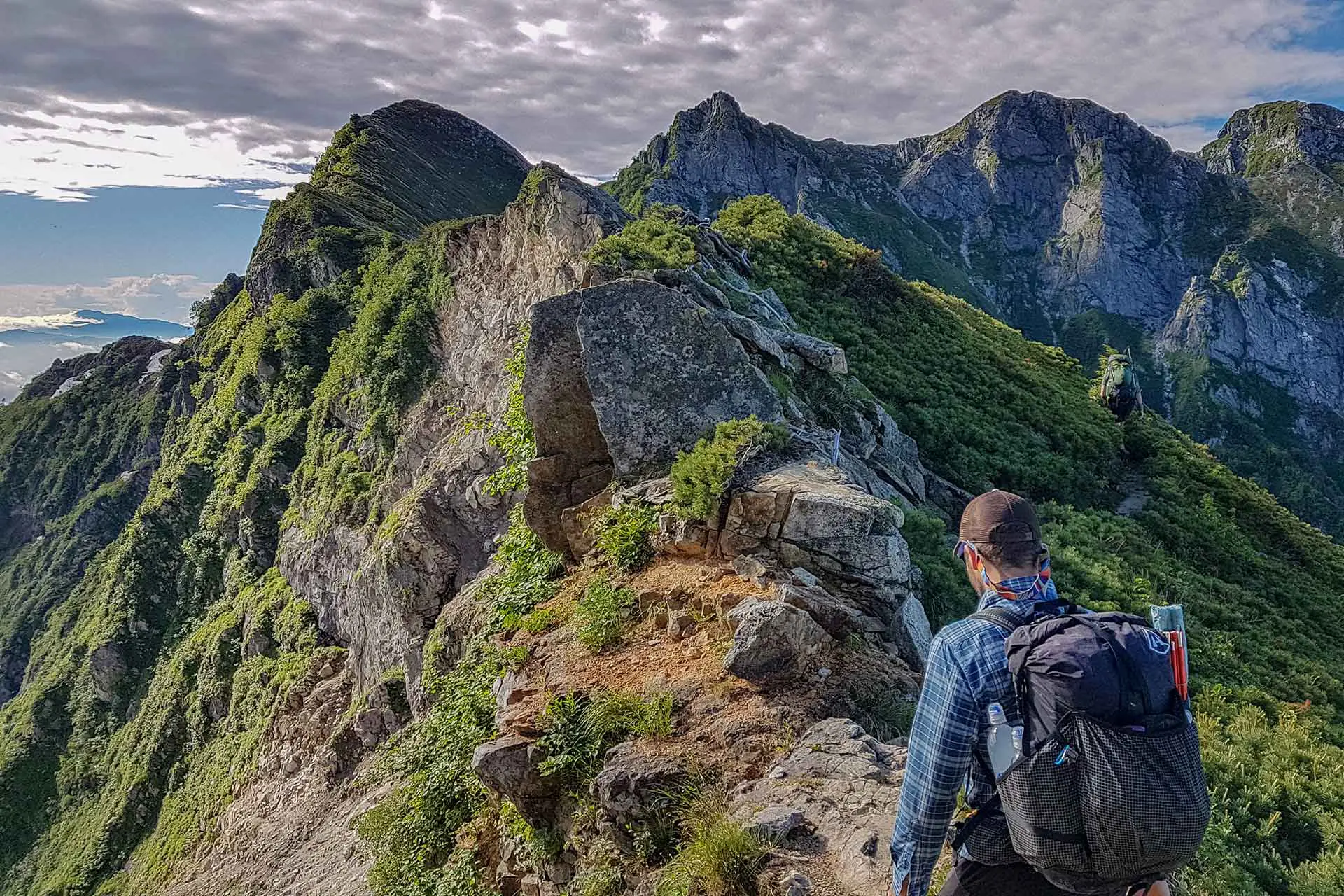
From the coast, my hiking party of two Kiwis and I headed up the northernmost ridgeline in the Kita Alps (北アルプス) – aka the Northern Alps. The trip began with nearly a week of nonstop rain as we traversed – it wasn’t until day four that we saw another person and it wasn’t until day five that we actually saw another hiker on the trail (the people we saw on day four were employees at a mountain hut we camped at).

The Northern Alps stretch from where we began, at the Tsugami Shindo Trailhead, to Ontakesan (御嶽山), or Mount Ontake, in the south. The Kita Alps are the longest of the three ranges comprising the Japanese Alps (the Kita (Northern), Chuo (Central), and Minami (Southern)) and this stretch took the first half of the hike – seventeen days (this includes a trip in and out of Toyama (富山市) via train from Tateyama (立山) for a resupply).

The photos in this post are in order of north to south and the peaks covered in this section are listed at the bottom of this post. If you’re interested in the daily itinerary for this route, you can find it here.

Japan Traverse Kita Alps
After three days of rain, we decided to hike out into the storm.
Japan Alps Traverse Kita Alps Rainy Ridgeline
We didn’t see anyone for the first four days of hiking (not very popular up here).
Japan Alps Traverse Kita Alps Snow Traverse
There were a few minor traverses in the beginning where some spikes definitely would have helped.
Japan Alps Traverse Kita Alps Raicho
A raicho (aka thunderbird) – one of the few animals we saw on the traverse.
Japan Alps Traverse Kita Alps Clearing
One of the first good views we got on the entire hike (once the storm we began in finally broke).
Japan Alps Traverse Kita Alps Clouds
Not all of the alps are green and lush.
Japan Alps Traverse Kita Alps Ridgeline Hut
These huts may be perched on ridgelines, but they are serious structures.
Japan Alps Traverse Kita Alps Tom Descend
The late-afternoon clouds always did their best to greet us.
Japan Alps Traverse Kita Alps Kirettogoya
We were forced to pay to stay here (Kirettogoya) because the weather turned and there was literally nowhere for us to set up camp – the hut took the good spot.
Japan Alps Traverse Kita Alps
Can you spot the hut?
Japan Alps Traverse Kita Alps Noodles
Noodles – something you can find at most of the huts (sometimes hot water costs extra).
Japan Alps Traverse Kita Alps Hut Sleeping
What your sleeping situation will look like should you decide to stay in a hut.
Japan Alps Traverse Kita Alps Chain
You’ll find these chains everywhere in the Kita Alps (I don’t trust them).
Japan Alps Traverse Kita Alps Mac View
Honestly, I might end up doing something like this again.
Japan Alps Traverse Kita Alps Green Tunnel
Generally, the trails aren’t too overgrows, but we found a couple sections that were ungodly.
Japan Alps Traverse Kita Alps Steep Ridge
When I say that this entire hike is basically a ridgewalk, I’m not exaggerating.
Japan Alps Traverse Kita Alps Tom Paula Ridge
Once you’re above the treeline, you don’t really go back down until you leave the mountains.
Japan Alps Traverse Kita Alps Djedi Dome
Testing out the Dyneema Djedi Dome from LOCUS GEAR.
Japan Alps Traverse Kita Alps
In the case of a storm, you can’t just bail off the side – the mountains here are steep.
Japan Alps Traverse Kita Alps Sunrise Hut
A rare boardwalked section of trail.
Japan Alps Traverse Kita Alps River Trail
Heading down to Kurobe Lake from Harinokigoya was basically hiking down a river.
Japan Alps Traverse Kita Alps River
The only time we ever hiked along a river (I guess it’s hard when you’re ridgewalking most of the time).
Japan Alps Traverse Kita Alps Rope River Crossing
Luckily, this river crossing on our way to Kurobe Lake wasn’t too flooded.
Japan Alps Traverse Kita Alps Kurobe Dam Bridge
Crossing the bridge just before reaching the Kurobe Dam on the western side of the lake.
Japan Alps Traverse Kita Alps Kurobe Dam
The Kurobe Dam – home to lots of tourists and, more importantly, food.
Japan Alps Traverse Kita Alps Tateyama Group
Tateyama is a huge tourist area and there are restaurants, lodges, stores, and this big stone sign.
Japan Alps Traverse Kita Alps Tateyama campground
Sunset at the Tateyama campground.
Japan Alps Traverse Kita Alps Tateyama Snowfield
The largest snowfield we encountered – south of Tateyama.
Japan Alps Traverse Kita Alps Trail Traverse
Don’t forget, these mountains are filled with terribly annoying insects and the terrifying giant Japanese hornet.
Japan Alps Traverse Kita Alps Mountains
For a not-that-wide island, there sure are a lot of mountains here.
Japan Alps Traverse Kita Alps
If you see a peak in the distance, chances are you’re going over it.
Japan Alps Traverse Kita Alps Sugoroku Campground
Official campgrounds aren’t too common and the more accessible ones look like this.
Japan Alps Traverse Kita Alps Tom Yarigatake
Thomas, looking longingly at Yarigatake from the west – our goal for the day.
Japan Traverse Kita Alps Yarigatake Sign
Walking the ridgeline to Yarigatake from Sugorokudake.
Japan Alps Traverse Kita Alps Yarigatake Crowds
A look at how crowded the more popular peaks can get (we arrived here on a holiday – big mistake).
Japan Alps Traverse Kita Alps Yarigatake
Looking back at Yarigatake from the south.
Japan Alps Traverse Kita Alps Morning Ridge
The ridges are endless.
Japan Alps Traverse Kita Alps
The sun comes up early in the summer (like 5:00), and an early start is highly recommended. Just look at those faces.
Japan Alps Traverse Kita Alps Hut Ridge
This hut, just north of the Daikeretto (Big Cut) has camping (and noodles…and soda…).
Japan Alps Traverse Kita Alps Daikeretto
A look at the Daikeretto (or “Big Cut” between Yarigatake and Kitahodaka.
Japan Alps Traverse Kita Alps Steep Downclimb
The incredibly steep traverse from Okuhodaka to Nishihodaka.
Japan Alps Traverse Kita Alps Jandamuru
Jandarumu (ジャンダルム) is one of the most awesome spots on the traverse.
Japan Alps Traverse Kita Alps Mac Ridge
One of my favorite bits of hiking in the world right here.
Japan Alps Traverse Kita Alps Hut Front Desk
The front desk of a hut in the Kita Alps.
Japan Alps Traverse Kita Alps Yakedake Climb
Climbing up to the summit of Yakedake from the north (can you see the hut in the valley on the right?).
Japan Alps Traverse Kita Alps Yakedake Crater
The crater of Yakedake – an active volcano.
Japan Alps Traverse Kita Alps Road Walk
Walking the road after descending the southern side of Yakedake.
Japan Alps Traverse Kita Alps Norikuradake Approach
Approaching Norikuradake from the north (photo taken looking north).
Japan Alps Traverse Kita Alps Dead Insect
These things drove me absolutely mad. Kill them.
Japan Alps Traverse Kita Alps Ontakesan Trail
One of the worst sections of trail we encountered – neading up the north side of Ontakesan.
Japan Alps Traverse Kita Alps Ontakesan
The summit of Ontakesan – a volcano that erupted unexpectedly in 2014 and killed a bunch of hikers.

Kita Alps Peaks

  • Nyudoyama (入道山) – 1470 ft / 448 m
  • Shiritakayama (尻高山) – 2221 ft / 677 m
  • Sakatatoge (坂田峠) – 1903 ft / 580 m
  • Shiratoriyama (白鳥山) – 4222 ft / 1286.8 m
  • Shimokomagatake (下駒ヶ岳) – 4072 ft / 1241 m
  • Kikuishiyama (菊石山) – 3969 ft / 1209.7 m
  • Orenyama (黄蓮山) – 4462 ft / 1360 m
  • Inugatake (犬ヶ岳) – 5225 ft / 1592.5 m
  • Sawaganiyama (サワガニ山) – 5290 ft / 1612.3 m
  • Kuroiwayama (黒岩山) – 5327 ft / 1623.6 m
  • Nagatsugayama (長栂山) – 7438 ft / 2267 m
  • Asahidake (朝日岳) – 7047 ft / 2147.9 m
  • Yukikuradake (雪倉岳) – 8566 ft / 2610.9 m
  • Mikunisakai (三国境) – 9026 ft / 2751 m
  • Shiroumadake* (白馬岳) – 9620 ft / 2932.3 m
  • Maruyama (丸山) – 9081 ft / 2768 m
  • Shakushidake (杓子岳) – 9226 ft / 2812 m
  • Yarigatake (鑓ヶ岳) – 9525 ft / 2903.2 m
  • Tengu Peak (天狗の頭) – 9226 ft / 2812.1 m
  • Karamatsudake (唐松岳) – 8845 ft / 2695.9 m
  • Daikokudake (大黒岳) – 7851 ft / 2393 m
  • Shiradake (白岳) – 8337 ft / 2541 m
  • Goryudake* (五龍岳) – 9232 ft / 2814 m
  • Kashimayarigatake (North) (鹿島槍ヶ岳北峰) – 9324 ft / 2842 m
  • Kashimayarigatake* (鹿島槍ヶ岳) – 9479 ft / 2889.2 m
  • Nunobikiyama (布引山) – 8802 ft / 2683 m
  • Jiigatake (North) (爺ヶ岳北峰) – 8632 ft / 2631 m
  • Jiigatake (爺ヶ岳) – 8760 ft / 2669.9 m
  • Jiigatake (South Peak) (爺ヶ岳南峰) – 8727 ft / 2660 m
  • Iwagoyazawadake (岩小屋沢岳) – 8630 ft / 2630.5 m
  • Shinkoshinokkoshi (新越乗越) – 8077 ft / 2462 m
  • Narusawadake (鳴沢岳) – 8665 ft / 2641 m
  • Akazawadake (赤沢岳) – 8786 ft / 2678 m
  • Subaridake (スバリ岳) – 9029 ft / 2752 m
  • Harinokidake (針ノ木岳) – 9254 ft / 2820.7 m
  • Harinokitoge (針ノ木峠) – 8320 ft / 2536 m
  • Tateyama (Oyama)* (立山(雄山)) – 9852 ft / 3003 m
  • Ryuodake (龍王岳) – 9423 ft / 2872 m
  • Onidake (鬼岳) – 9022 ft / 2750 m
  • Shishidake (獅子岳) – 8904 ft / 2714 m
  • Zaratoge (ザラ峠) – 7703 ft / 2348 m
  • Tonbiyama (鳶山) – 8583 ft / 2616 m
  • Echuzawadake (越中沢岳) – 8503 ft / 2591.6 m
  • Sugonoatama(?) (スゴの頭) – 7976 ft / 2431 m
  • Mayama (間山) – 8482 ft / 2585.4 m
  • Yakushidake (North) (北薬師岳) – 9514 ft / 2900 m
  • Yakushidake* (薬師岳) – 9600 ft / 2926 m
  • Yakushitoge (薬師峠) – 7526 ft / 2294 m
  • Taroyama (太郎山) – 7785 ft / 2373 m
  • Kitanomatadake (北ノ俣岳) – 8733 ft / 2661.9 m
  • Akagidake (赤木岳) – 8602 ft / 2622 m
  • Nakamatanokkoshi (中俣乗越) – 8038 ft / 2450 m
  • Kurobegorodake* (黒部五郎岳) – 9645 ft / 2939.7 m
  • Mitsumatarengedake (三俣蓮華岳) – 9322 ft / 2841.4 m
  • Maruyama (丸山) – 9364 ft / 2854 m
  • Sugorokudake (双六岳) – 9385 ft / 2860.4 m
  • Momisawadake (樅沢岳) – 9039 ft / 2755 m
  • Ionokkoshi (硫黄乗越) – 8399 ft / 2560 m
  • Senjo Junction (千丈乗越) – 8957 ft / 2730 m
  • Yarigatake* (槍ヶ岳) – 10433 ft / 3180 m
  • Hidanokkoshi (飛騨乗越) – 10105 ft / 3080 m
  • Obamidake (大喰岳) – 10180 ft / 3103 m
  • Nakadake (中岳) – 10118 ft / 3084 m
  • Minamidake (南岳) – 9950 ft / 3032.9 m
  • Daikeretto (大キレット) – 9016 ft / 2748 m
  • Kita-Hotakadake (北穂高岳) – 10190 ft / 3106 m
  • Karasawadake (涸沢岳) – 10203 ft / 3110 m
  • Oku-Hotakadake* (穂高岳) – 10466 ft / 3190 m
  • Gendarme (ジャンダルム) – 10377 ft / 3163 m
  • Tengunoatama (天狗ノ頭) – 9544 ft / 2909 m
  • Ainodake (間ノ岳) – 9537 ft / 2907 m
  • Nishihotakadake (西穂高岳) – 9543 ft / 2908.8 m
  • Nishihodoppyo (西穂高岳 独標) – 8862 ft / 2701 m
  • Nishiomaruyama (西穂 山荘) – 8045 ft / 2452 m
  • Waritaniyama (割谷山) – 7297 ft / 2224.2 m
  • Shinnakaotoge (新中尾峠) – 7021 ft / 2140 m
  • Nakatoge (中尾峠) – 7021 ft / 2140 m
  • Yakedake* (焼岳) – 8056 ft / 2455.5 m
  • Iodake (硫黄岳) – 8379 ft / 2554 m
  • Daikokudake (大黒岳) – 9094 ft / 2772 m
  • Fujimidake (富士見岳) – 9242 ft / 2817 m
  • Kodamadake (蚕玉岳) – 9760 ft / 2975 m
  • Kengamine (剣ヶ峰) – 9927 ft / 3025.7 m
  • Mamakodake (継子岳) – 9380 ft / 2859.1 m
  • Hidachojo (御嶽四の池) – 9226 ft / 2812 m

Peaks denoted with an asterisk (*) are part of Nihon Hyakumeizan (100 Famous Japanese Mountains).

You'll Like These Too:

Share this post:

Share on Facebook Share on Twitter Share on Pinterest Share on Reddit Share on WhatsApp Share on Email

Japan,  Japan,  Japan Alps Traverse,  Photo Gallery Kita Alps,  Photography

Subscribe
Notify of
guest
guest
2 Comments
Most Voted
Newest Oldest
Inline Feedbacks
View all comments

Primary Sidebar

Most Recent Posts

  • Continental Divide Trail Hiker Survey (2022)
  • Pacific Crest Trail Resupply Guide (2022 Survey)
  • The Pacific Crest Trail Gear Guide: Class of 2022 Survey
  • Pacific Crest Trail Hiker Survey (2022)
  • Zpacks Zip Around Sleeping Bag Review
Backpacking Gear Pacific Crest Trail Continental Divide Trail Mac's Backpack

Footer

STAY IN TOUCH

You've made it this far, you're either into this site or you're still looking for something. Either way, best to sign up for my newsletter, yeah?

NAVIGATION

  • Recent Posts
  • Backpacking Gear
  • Continental Divide Trail
  • Pacific Crest Trail
  • Brazil Trekking
  • Japan Trekking
  • Nepal Trekking
  • New Zealand Trekking
  • Tasmania Trekking

LEGALESE

  • Privacy Policy
  • Cookie Policy
  • Terms and Conditions

Copyright © 2023 · Halfway Anywhere