Pacific Crest Trail Side Quests: The Sierra
Pacific Crest Trail side quests are objectives PCT hikers can choose to accomplish during their hikes, but that don’t need to be completed to finish a PCT thru-hike.
Before beginning a Pacific Crest Trail hike – or perhaps any thru-hike – it’s common for would-be hikers to spend vast amounts of time meticulously researching, planning, and mulling over their coming adventure.
I would wager many hours spent “planning” are simply a means of justifiably procrastinating anything else a PCT hiker could be doing before their hike, but I’m not here to judge. I’m here to do the opposite – to give you even more options when it comes to things to plan, research, and consider before setting out on a PCT hike.

Need to Know
Side quests are listed in geographical order from south to north. Some side quests are only applicable to Pacific Crest Trail hikers traveling in a particular direction (i.e., northbound or southbound).
I have assigned each of the Pacific Crest Trail side quests four ratings, an interest factor, difficulty factor, inconvenience factor, and a stupid factor.
All these are scored on a scale of 1 to 10 with a clarification of each scale below.
Also, the mileage used in all the below descriptions is based on data from FarOut. These mileages can change as the PCT is always being rerouted and (hopefully) improved – consider them approximate. If you aren’t already familiar with FarOut and you’re going to hike the PCT, you should invest in the app.
Interest Factor
Despite what you read in your overpriced guidebook, not all side quests are particularly interesting. This is an assessment of where the side quest falls on a scale of “not worth your time” to “absolutely should attempt”.
Difficulty Factor
It isn’t unreasonable to encounter a side quest that’s more challenging than any single stage of the Pacific Crest Trail. This is a rating of how difficult the side quest is to accomplish on a scale of “zero effort needed” to “significant physical or logistical effort needed”.
Inconvenience Factor
Sometimes a side quest might be interesting and easy, but it may be a huge hassle. This is a gauge of how inconvenient a side quest is on a scale of “will not alter your hike whatsoever” to “enormous pain in the ass”.
Stupid Factor
Some side quests have become part of Pacific Crest Trail lore and/or the PCT hiker culture that some may consider to be undeserving of such consideration. This metric rates how stupid a side quest is on a scale of “no at all” to “dumb af”.

Mount Whitney Summit
Interest: ⭐⭐⭐⭐⭐⭐⭐⭐⭐⭐
Difficulty: ⚠️⚠️⚠️⚠️⚠️⚠️
Inconvenience: 😫😫😫😫
Stupid: 💩
Summary
The 14,505 ft / 4,421 m high summit of Mount Whitney is the highest peak in the Sierra Nevada and the highest point in the Continental United States. It’s a hugely popular side quest for Pacific Crest Trail hikers as the PCT passes just west of the summit.
What’s more, is that you do not need a permit to summit Mount Whitney from the west. However, you cannot descend or ascend the eastern side, the Whitney Portal Trail, without a permit (which is distributed months in advance via lottery or obtained via walk-up).
A roundtrip hike to the summit of Mount Whitney from the PCT is 16.2 mi / 26.07 km with 3,730 ft / 1,137 m of elevation gain and an equal amount of loss.
Interest
Top marks for Mount Whitney. If there’s anything on the Pacific Crest Trail that’s a must-do detour, this is it.
Difficulty
The difficulty of the climb up Mount Whitney depends on how well you’re coping with altitude, how much snow and/or ice there still is on the trail, and the current weather conditions. The trail itself is well-maintained and easy to follow. There is nothing technically difficult about the trail in dry conditions when it’s clear of snow.
However, if you’re climbing Mount Whitney in a high snow year or early in the season, it’s wise that you carry with you an ice axe and foot traction; and it’s always wise to carry the knowledge you may need to turn around.
Inconvenience
Getting to the top of Mount Whitney in favorable conditions is a minor inconvenience. The roundtrip hike is 16.2 mi / 26.07 km and requires 3,730 ft / 1,137 m of elevation gain (and the same amount of loss). This means that you’ll likely be carrying an extra day’s worth of food.
If you’re hiking in unfavorable weather, struggling with altitude, or don’t have the gear to safely cross patches of snow/ice, then getting to the top may prove more of an inconvenience – even crossing into the stupid category.
Stupid
Like the summits of San Jacinto and San Gorgonio further south along the Pacific Crest Trail, the only reason climbing Mount Whitney would be stupid is if you were putting yourself at risk by doing so. That is to say, if you are struggling at altitude, running out of food, don’t have proper gear for the conditions, or the weather is against you.

Sierra High Route
Interest: ⭐⭐⭐⭐⭐⭐⭐⭐⭐⭐
Difficulty: ⚠️⚠️⚠️⚠️⚠️⚠️⚠️⚠️⚠️⚠️
Inconvenience: 😫😫😫😫😫😫😫😫😫😫
Stupid: 💩💩💩💩💩💩💩💩💩💩
Summary
The Sierra High Route is a fantastic (mostly) off-trail route through the Sierra Nevada. It essentially parallels the Pacific Crest Trail and overlaps for some small sections. I’m not going to go into everything the SHR encompasses here but suffice it to say it’s an incredible off-trail route through the Sierra that could conceivably be an alternative to the PCT for a section.
Interest
The Sierra High Route is spectacular – an absolute must-do, but not necessarily as part of a Pacific Crest Trail thru-hike. Maximum amount of interest points. Add it to your list if you haven’t already.
Difficulty
Compared to the Pacific Crest Trail, the Sierra High Route is incredibly difficult. For most of it, you’ll be traveling cross-country, scrambling up passes covered in talus, sliding down scree-covered slopes, and visiting some of the most remote terrain in the Sierra. Maximum difficulty points for a SHR hike as part of PCT thru-hike.
Inconvenience
Assuming you have the experience and the gear to complete a Sierra High Route hike, the inconvenience would come mostly from the fact that you would be required to get a separate permit for your SHR hike – the SHR is not covered by a Pacific Crest Trail permit – and the additional planning that would be necessary to prepare for the SHR. You won’t be able to just follow FarOut.
Planning a thru-hike within a thru-hike? Maximum inconvenience.
Stupid
Hiking the Sierra High Route as part of a Pacific Crest Trail thru-hike would undoubtedly be awesome, but would also be stupid – particularly if you’ve never hiked in the Sierra before. The PCT travels through some of the Sierra’s most spectacular areas and it overlaps with the Sierra High Route multiple times.
If you’ve already hiked the Pacific Crest Trail once and are out for a second round, the Sierra High Route might be something to consider. But remember it would be a thru-hike within a thru-hike and the SHR is nothing like the PCT in terms of difficulty or navigational challenges.

Kennedy Meadows to Vermilion Valley Resort (VVR)
Interest: ⭐⭐⭐⭐
Difficulty: ⚠️⚠️⚠️⚠️⚠️⚠️
Inconvenience: 😫😫😫😫
Stupid: 💩💩💩
Summary
Kennedy Meadows to Vermilion Valley Resort (VVR) describes a resupply stretch in the Sierra. Essentially this means hikers leave Kennedy Meadows (commonly considered the beginning or end of the Sierra Nevada section of the Pacific Crest Trail) and hike through to Vermilion Valley Resort without stopping to resupply in between.
Because there are multiple trails into VVR the exact distance of this stretch can vary but it’s approximately 180 mi / 290 km with around 35,000 ft / 10,668 m of elevation gain.
Interest
The most interesting thing about this side quest is that it means hikers will be on the trail – without crossing a road for around 180 mi / 290 km – depending on which trail into/out of Vermilion Valley Resort hikers take.
It gets four stars for interesting. There’s nowhere else on the Pacific Crest Trail (or in the Continental United States, I would wager) where you can hike such a well-maintained trail through pristine alpine environments for this long.
If you really wanted to go as far as possible without seeing a road, you could hike the stretch between Kennedy Meadows and Tuolumne Meadows for a truly epic stretch – adding an additional 70ish miles (113 km). But this would require either moving quite fast or carrying a ton of food (and remember that your food carry is limited in the Sierra by the size of your bear canister).
Difficulty
This stretch can be made significantly more difficult when the ground is still covered in snow. The precise difficulty of the Kennedy Meadows to VVR hike (or the reverse) will depend heavily on your personal fitness, how quickly you’re moving through the Sierra, and how much food you’re willing to carry and/or ration.
It’s worth noting that this section also encompasses the hike up Mount Whitney. If you’re also hoping to hike to the summit of Mount Whitney during this stretch, you’ll need to account for the additional time/food you’ll need.
This stretch gets a six for difficulty as I expect it will be a little tough for the average PCT thru-hiker – especially those heading northbound and/or those wanting to summit Mount Whitney.
Inconvenience
Four points for inconvenience as it could be easily argued that hiking this stretch is more convenient than the alternative taken by many Pacific Crest Trail hikers – hiking over Kearsarge Pass to Onion Valley and resupplying in either Independence or Bishop.
The most inconvenient part of this side quest is the extra food you’ll be carrying for the first few days leaving either Kennedy Meadows or VVR.
Stupid
Is hiking from Kennedy Meadows through to VVR (or the reverse) stupid? Three stupid points.
The argument for this being stupid is that it may require hikers to rush through what’s consistently one of thru-hikers’ favorite sections of the Pacific Crest Trail.
A lot of hikers report on the PCT Survey they wish they had slowed down more during their hikes. Perhaps the Sierra isn’t the best place to rush.

Devils Postpile National Monument
Interest: ⭐⭐⭐⭐⭐⭐⭐
Difficulty: ⚠️
Inconvenience: 😫
Stupid: 💩
Summary
Devils Postpile National Monument is located just off the Pacific Crest Trail near Red’s Meadow outside Mammoth Lakes, California. According to the National Park Service, “The formation is a rare sight in the geologic world and ranks as one of the world’s finest examples of columnar basalt.”
The easiest way to access Devils Postpile is via Northbound Mile 908.4 or Southbound Mile 1745. There’s a trail parallel to the PCT that hikers can follow to visit the monument. Depending on how much you explore the monument, you’ll either add no distance to your hike or maybe a few hundred meters.
Interest
Along with Mount Whitney, Devils Postpile is as close to a must-do as you’ll encounter on the Pacific Crest Trail. Even if you aren’t particularly interested in the monument, it’s so close to that trail that you might as well pay a visit.
If you’re into rocks (and by this point in the PCT you might be just a little), it’s definitely a must-see.
Seven interesting points for Devils Postpile.
There’s also a toilet at the vehicle-accessible parking lot if that’s of any interest to you. Again, by this point in the trail, it probably will be.
Difficulty
It’s easy to get to Devils Postpile from the Pacific Crest Trail. You simply take a trail parallel to the PCT and hike past the monument instead of staying west of it.
Devils Postpile is perhaps the most attainable hiking-related PCT side quest on the entire route.
One difficulty point.
Inconvenience
The only inconvenient things about Devils Postpile are potentially the fact that you’re going to be moderately slowed down as you gaze at the basalt columns and that you’re likely going to have to deal with crowds of day hikers.
Not even day hikers, just people who took the bus down and are walking a few hundred steps from the parking lot.
One inconvenience point.
Stupid
As with the difficulty and inconvenience, no real reason to think this is a stupid side quest. Go forth and check out yet another interesting feature of the Sierra Nevada.
One stupid point.

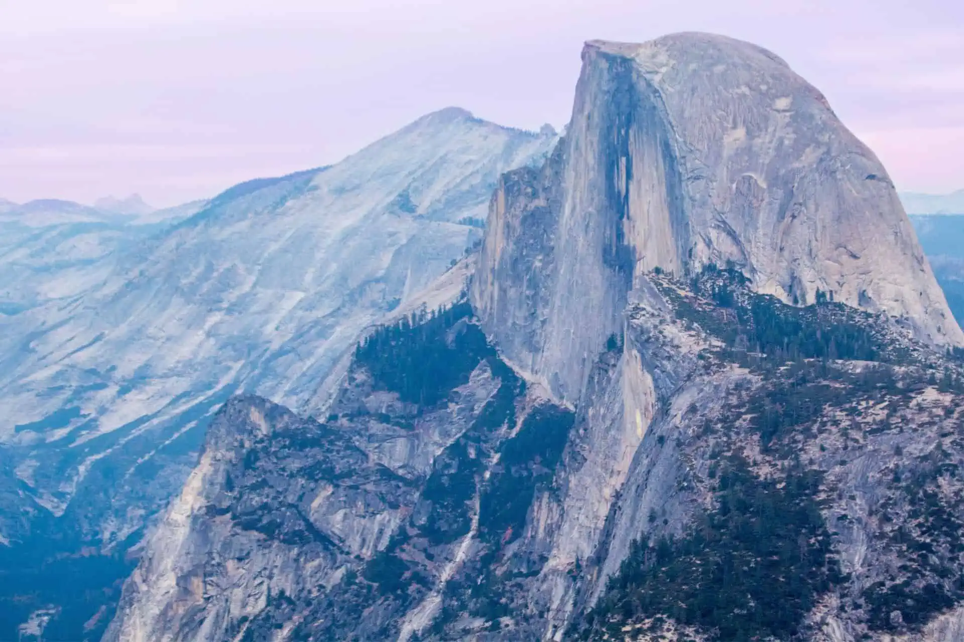
Yosemite Valley
Interest: ⭐⭐⭐⭐⭐⭐⭐⭐⭐⭐
Difficulty: ⚠️⚠️
Inconvenience: 😫😫😫😫😫
Stupid: 💩💩
Summary
Despite the Pacific Crest Trail passing through Yosemite National Park for 68 mi / 110 km, it doesn’t visit the iconic Yosemite Valley most people may be familiar with (photographs of). The Valley is where you can find the iconic views of El Capitan, Half Dome, Yosemite Falls, and more.
Pacific Crest Trail hikers can either hike or hitchhike to Yosemite Valley. Once inside the valley, PCT hikers will need to arrange accommodation at one of the Valley campsites – Upper Pines, Lower Pines, North Pines, or Camp 4 – or one of the Valley lodges/hotels.
Interest
If you don’t expect to be back in California’s Sierra Nevada anytime soon, a trip to Yosemite Valley is worth considering. It could be argued this trip is a must-do, but because it can be inconvenient to reach from the PCT, it doesn’t quite meet that bar.
Ten starts for interest – what could be more interesting to someone who’s hiked all this way on the PCT? I remind you there’s food and flushing toilets there, too.
Difficulty
It’s not difficult to reach Yosemite Valley. Yes, if you decide to hike there things may end up being more difficult, but the easiest way is to hitchhike.
That said, there’s also a bus that runs once a day between Yosemite Valley and Tuolumne (where the Pacific Crest Trail crosses the road in the park) in each direction. It typically leaves the Valley for Tuolumne in the early morning and leaves Tuolumne for the Valley in the early afternoon.
Alternatively, you can choose to hike to Yosemite Valley from Tuolumne Meadows. It’s around 22 mi / 36 km of mostly downhill hiking to the Valley. From there, you can either hike back up or hitch back to Tuolumne.
Keep in mind that if you want to camp on the way down to the Valley (or on the way back up), you’ll need an additional permit. There are backcountry ranger stations in both Tuolumne and the Valley.
Two points for difficulty.
Inconvenience
Yes, hiking, hitching, or taking a bus might be inconvenient, but the real inconvenience that comes from visiting Yosemite Valley has to do with the time you’ll take away from the PCT.
You may be sad about leaving your trail friends behind (just do it, you’ll find them again or you’ll make new ones) or be worried about making it to the end of your hike on time, but Yosemite Valley is worth the visit – particularly if you’re not going to be back in the area for the foreseeable future (i.e. you don’t live in the Western United States).
Five points for inconvenience. It would be four but the fact that you may need to get another permit depending on what you’re planning to do in the Valley bumps it up a bit.
Stupid
Visiting the Valley is never a stupid idea; unless you’re doing so with a car on a holiday weekend in the middle of summer.
As a hiker, the Valley is an awesome place to be. There is a free shuttle that you can use to get around the Valley floor and that will take you to visit all the iconic landmarks and granite walls you’ve likely seen in so many photos.
Two stupid points just because the Valley is so far from the Pacific Crest Trail. Stupid, PCT.

Half Dome
Interest: ⭐⭐⭐⭐⭐⭐⭐⭐
Difficulty: ⚠️⚠️⚠️⚠️⚠️⚠️
Inconvenience: 😫😫😫😫😫😫😫😫
Stupid: 💩💩
Summary
Half Dome is an iconic quartz monzonite batholith in Yosemite Valley and is one of the park’s most iconic features. Every year, cables are erected on the backside of Half Dome (no, not the side that’s a vertical wall)
Interest
Half Dome gets an eight on the interest scale.
It’s an iconic landmark that’s become so popular a quota system has been implemented to prevent people from loving it to death. The cables up the back are a unique experience and the hike is certainly worth doing once.
It doesn’t get maximum interest marks since there are still 225 people permitted to climb each day and I know crowds can be a huge turnoff – especially for thru-hikers.
Difficulty
I’m giving Half Dome a five on the difficulty scale.
The trail up the cables is significantly steeper than anything hikers will encounter on the Pacific Crest Trail. This will likely put it out of the comfort zone of many PCT hikers, but it will be well within the skillset for many.
The most exposed bit of the hike up is relatively short. The hike to and from Half Dome either from Tuolumne Meadows or Yosemite Valley should be fairly easy for any PCT hiker who’s made it this far – regardless of the direction of their hike.
Yes, many people use harnesses and gloves on the cables to make their ascent more secure. I suspect you won’t have access to these as a PCT hiker – perhaps something to keep in mind.
Inconvenience
Unfortunately, hiking Half Dome can be an incredibly inconvenient endeavor as you’re required to get a permit ahead of time. If you’re lucky with the lottery and your guess of when you’ll be at Half Dome, the advance lottery is in March.
For the rest of us, there are daily permit lotteries between the end of May and the start of October. This lottery allows you to get a reservation for two days from whenever you enter – i.e. if you entered on July 4 and won, you would receive a permit for July 6.
Please note that permits are required 24 hours a day, seven days per week. Ascending the subdome or Half Dome cables without a permit is punishable by a fine of up to $5,000 and/or six months in jail. Not worth it – particularly if you intend on finishing your PCT hike.
You can hike to Half Dome from either the Valley or from Tuolumne depending on how much you want to hike (the hike from the Valley is shorter). You could also try to get a backcountry permit for the night before you summit Half Dome and camp somewhere in the area to get a jump on the other 224 people with permits for the same day.
Stupid
It’s not a stupid idea to hike Half Dome as part of your Pacific Crest Trail thru-hike unless you’re pressed for time or intend on doing so without a permit. That said, Half Dome is incredibly steep and if you’re unstable on steep slabs and/or may want the use of equipment you may not have (e.g. a harness), then maybe Half Dome shouldn’t be part of your PCT hike.

Wrap Up
It’s easy to get excited when planning a Pacific Crest Trail hike and imagine you’re going to do ALL THE THINGS. However, the reality is often different from the idealistic plans you make beforehand.
Oftentimes, you’ll be exhausted from hiking, and the thought of venturing off the PCT or adding any complications to your thru-hike will seem like madness. That said, other times you may be inspired to put in some extra effort and get some bonus XP.
Have a Pacific Crest Trail Sierra side quest that you believe is worthy of making this list? Know of a Sierra Nevada side quest that more PCT hikers should be taking advantage of?
Leave a comment below or get in touch!
Affiliate Disclosure: This page may contain affiliate links, which means I may receive small commissions for purchases made via these links at no additional cost to you. This helps pay the bills and keep the site up and running. Thank you for your support!

“What’s more, is that you do not need a permit to summit Mount Whitney from the west”
Can you elaborate on that a little more? i do not see a trail going up the west side only from the center and the east side via mountineering route
The PCT passes west of Mount Whitney near Crabtree Meadow. You can hike up to Mount Whitney via Crabtree Meadow and Guitar Lake (the same route the John Muir Trail takes) to reach the summit without a permit.
However, if you exit via Whitney Portal, you are required to have a Whitney permit to reenter via the Portal. Most hikers summit Mount Whitney as a day trip from the PCT.