Pacific Crest Trail Side Quests: The Desert
Pacific Crest Trail side quests are objectives PCT hikers can choose to accomplish during their hikes, but that don’t need to be completed to finish a PCT thru-hike.
Before beginning a Pacific Crest Trail hike – or perhaps any thru-hike – it’s common for would-be hikers to spend vast amounts of time meticulously researching, planning, and mulling over their coming adventure.
I bet many hours spent “planning” are simply a means of justifiably procrastinating anything else a PCT hiker could be doing before their hike, but I’m not here to judge. I’m here to do the opposite – to give you even more options when it comes to things to plan, research, and consider before setting out on a PCT hike.

Need to Know
Side quests are listed in geographical order from south to north. Some side quests are only applicable to Pacific Crest Trail hikers traveling in a particular direction (i.e., northbound or southbound).
I have assigned each of the Pacific Crest Trail side quests four ratings, an interest factor, difficulty factor, inconvenience factor, and a stupid factor.
All these are scored on a scale of 1 to 10 with a clarification of each scale below.
Also, the mileage used in all the below descriptions is based on data from FarOut. These mileages can change as the PCT is always being rerouted and (hopefully) improved – consider them approximate. If you aren’t already familiar with FarOut and you’re going to hike the PCT, you should invest in the app.
Interest Factor
Despite what you read in your overpriced guidebook, not all side quests are particularly interesting. This is an assessment of where the side quest falls on a scale of “not worth your time” to “absolutely should attempt”.
Difficulty Factor
It isn’t unreasonable to encounter a side quest that’s more challenging than any single stage of the Pacific Crest Trail. This is a rating of how difficult the side quest is to accomplish on a scale of “zero effort needed” to “significant physical or logistical effort needed”.
Inconvenience Factor
Sometimes a side quest might be interesting and easy, but it may be a huge hassle. This is a gauge of how inconvenient a side quest is on a scale of “will not alter your hike whatsoever” to “enormous pain in the ass”.
Stupid Factor
Some side quests have become part of Pacific Crest Trail lore and/or the PCT hiker culture that some may consider to be undeserving of such consideration. This metric rates how stupid a side quest is on a scale of “no at all” to “dumb af”.

Lake Morena on Day One
Interest: ⭐
Difficulty: ⚠️⚠️⚠️⚠️⚠️
Inconvenience: 😫😫😫
Stupid: 💩💩💩
Summary
This side quest is for northbound hikers only. It’s exactly what it sounds like, you hike to Lake Morena (approximately 20 mi / 32 km) on day one of your PCT hike.
I’ve already written a detailed article on why there’s no need (and why it’s oftentimes not wise) to hike to Lake Morena on day one of a Pacific Crest Trail thru-hike. But I’m sure that’s not going to stop many fresh PCT hikers from attempting it anyway.
Interest
There’s no reason or benefit to hiking to Lake Morena on day one of a thru-hike which is why this side quest earns an interest factor of one. Twenty miles (32 km) may seem like a big day to you at the start of your hike, but for most hikers, this distance will be trivial by the time they reach Northern California or Oregon.
Difficulty
It earns a difficulty factor of five as it will undoubtedly be quite difficult or even impossible for some hikers but rather easy for others. Remember that because this is an average your personal difficulty factor here could be as low as one or as high as ten.
Inconvenience
As for the inconvenience of it, you’ll need to pay for camping at Lake Morena, you’ll be pressed for time on your first day, and you’ll want to start early which could mean a more logistically-heavy southern terminus transport situation. On the other hand, you’ll have flushing toilets and showers at Lake Morena and you’ll be able to walk a short distance down to the market (map) for snacks if you get there early enough. I put the inconvenience level at three.
Stupid
It’s stupid for all hikers to feel pressure to hike a 20 mi / 32 km day on their first day of hiking. However, if you’re capable of making it to Lake Morena, there’s no reason why doing so would be a stupid decision. This earns hiking to Lake Morena on day one of a PCT hike a stupid rating of three.
San Jacinto Summit
Interest: ⭐⭐⭐⭐⭐⭐⭐⭐⭐⭐
Difficulty: ⚠️⚠️⚠️
Inconvenience: 😫😫
Stupid: 💩
Summary
Climb to the 10,834 ft / 3,302 m summit of Mount San Jacinto, just east of the Pacific Crest Trail. There are two options for reaching the summit, the Wellman’s Cienega Trail (northbound mile 181.2 / southbound mile 2474) and the Deer Creek Trail (northbound mile 185.7 / southbound mile 2470)
You can either do an out-and-back hike via the Wellman’s Cienega Trail or the Deer Creek Trail or you can connect the two via the summit. The latter option is 5.7 mi / 9.2 km long with around 3,600 ft 1,100 m of elevation change but will bypass approximately 4 mi / 6.4 km of the PCT. Not that you should care about missing these unremarkable miles of the PCT, just something of note.
Interest
The interest factor of San Jacinto Peak gets maximum marks. On a clear day, you can look west and see to Catalina Island off the coast of Southern California. It’s the second-highest peak in Southern California behind San Gorgonio (visible to the north from San Jacinto), the tallest peak in the San Jacinto Mountains, and the sixth-most-prominent peak in the Contiguous United States.
Apparently, the racist American naturalist John Muir said, “The view from San Jacinto is the most sublime spectacle to be found anywhere on this earth.” I would disagree that it’s the most sublime spectacle on Earth, but it’s pretty nice.
Difficulty
If you’ve made it this far up San Jacinto from either the south or the north, reaching the summit won’t be much more of an effort. Yes, it’s 1,600 ft / 487 m of climbing, but it’s all on a nicely graded trail (no matter which you choose). However, in winter conditions this climb can be significantly more difficult. If this is the case, it’s recommended you have foot traction and possibly an ice axe depending on the conditions. Difficulty score? Three.
Inconvenience
It’s a short detour with a big reward, the summit of San Jacinto. Yes, you may be tired and the extra climbing and distance may seem like an inconvenience, but you’ll probably be happy you put in the effort. That said, if it’s cloudy, covered in snow, or struggling and wanting to get off the mountain, it could be an inconvenient side trip. I give it an inconvenience score of two. It’s one of the best effort-reward side quest values of the entire PCT.
Stupid
There’s nothing stupid about hiking to the summit of San Jacinto. However, you can make the decision to climb to the summit of San Jacinto a stupid one if you do so in snowy/icy conditions and without the proper gear and/or experience. Stupid factor of one.
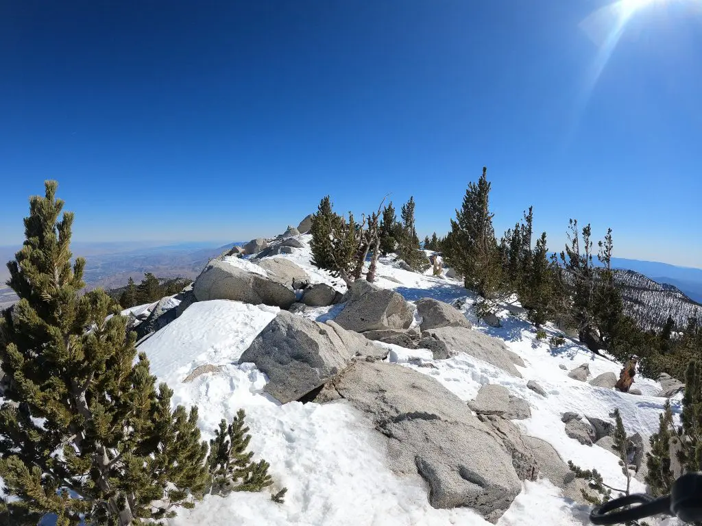
San Gorgonio Summit
Interest: ⭐⭐⭐⭐⭐⭐⭐
Difficulty: ⚠️⚠️⚠️⚠️⚠️
Inconvenience: 😫😫😫😫😫😫😫
Stupid: 💩💩
Summary
It’s a 10.4 mi / 16.7 km one-way hike to the 11,503 ft / 3,506 m summit of San Gorgonio – the highest peak in Southern California. A roundtrip hike to the summit from the Pacific Crest Trail would be 20.8 mi / 33.4 km and require nearly 8,000 ft / 2,440 m of combined elevation gain/loss.
Hikers depart heading westbound from PCT northbound mile 240 / southbound mile 2415.2 to reach the summit. Many hikers will burn an entire day or more to complete the detour.
Interest
As the highest peak in Southern California, San Gorgonio is a tempting objective for Pacific Crest Trail hikers. If you’re hiking northbound, you’ll be able to see the summit as you drop down Fuller Ridge (or from the summit of San Jacinto, if you decide to make the detour). If you’re hiking southbound, San Gorgonio is visible from the summit of Mount Whitney.
That said, the peak is not a relatively well-known peak outside the area and may not be as desirable an objective as something like Mount Whitney, for example. For that reason, it earns an interest factor of seven. Not an absolute must-do, but certainly not something to be shrugged off either. Consider this one.
Difficulty
San Gorgonio can hold snow until late into the year, so if you’re an early-season northbound thru-hiker, the summit may prove to be challenging. However, there is a trail leading to the summit from the Pacific Crest Trail and so long as the trail is clear of ice/snow and you have favorable weather, reaching the summit shouldn’t be a technically difficult prospect.
The most difficult part of reaching the summit will be convincing yourself the detour from the PCT is worth it and the nearly 4,000 ft / 1,220 m of climbing a roundtrip journey to the summit requires. Difficulty rating? Five.
Inconvenience
The hike to the summit of San Gorgonio may be straightforward (outside winter conditions), but it will likely take a day or more out of many PCT hikers’ hikes. The extra time needed, the extra food hikers will need to carry, and the potential for weather making this trip potentially more trouble than it’s worth earns San Gorgonio an inconvenience factor of seven.
You’ll also need a permit to day hike or camp in the San Gorgonio Wilderness. Find out permit information here.
Stupid
The only argument I could see made for this side quest being stupid is that it’s too far from the Pacific Crest Trail to be considered an objective. That said, it’s possible to tag the summit from and return to the PCT in a single day; that argument doesn’t hold much water. Alternatively, if attempted in winter conditions without the proper gear and/or experience, that could turn this quest into quite a stupid one. Stupid factor of two.

Mount Baden-Powell Summit
Interest: ⭐⭐⭐⭐⭐⭐⭐⭐⭐
Difficulty: ⚠️⚠️
Inconvenience: 😫😫
Stupid: 💩
Summary
Leave the Pacific Crest Trail at northbound mile 377.9 / southbound mile 2277 to reach the 9,407 ft / 2,867 m summit of Mount Baden-Powell via a 0.2 mi / 322 m detour. The trail to the summit connects to the PCT on either side which means PCT hikers do not need to backtrack to reach the summit.
Interest
The summit of Mount Baden-Powell is one that’s much sought after by hikers living in Southern California. With it being so close to the Pacific Crest Trail, there’s little reason not to tag it unless there’s perhaps lingering ice and/or snow making conditions dangerous.
Nine points for interest instead of ten because the summit doesn’t offer the most spectacular views. Nice views, to be sure, but probably not anything you’re going to be putting in your top ten favorite places of the PCT.
Difficulty
Two points for the difficulty of summiting Mount Baden-Powell. It’s a short and quick detour to the summit and you can reconnect back to the Pacific Crest Trail independent of the direction you’re traveling. That said, this could potentially be increased significantly if there’s lingering ice or snow.
Inconvenience
You’re not going to find a more convenient peak to tag on the Pacific Crest Trail. Two inconvenience points because you’ll need to climb an additional 150 ft / 45 m to reach the summit. If this amount of extra elevation scares you, you’re going to have problems elsewhere on the trail (or maybe you’re just a very tired southbound thru-hiker).
The trail to the summit connects on both the north and west sides meaning you don’t need to do an out-and-back hike to reach Mount Baden-Powell – convenience at its finest.
Stupid
Nothing at all stupid about tagging the summit of Mount Baden-Powell during a Pacific Crest Trail thru-hike. The only thing stupid is that it’s not technically on the PCT. One stupid point. It would be stupid not to tag it (unless there’s a harrowing amount of snow and conditions are unsafe).

McDonald’s Challenge
Interest: ⭐⭐
Difficulty: ⚠️⚠️⚠️
Inconvenience: 😫😫😫😫😫
Stupid: 💩💩💩💩💩💩💩
Summary
At northbound mile 341.9 / southbound mile 2313.3 there’s a 0.3 mi / 500 m detour PCT hikers can take to the McDonald’s at Cajon Pass. This is generally a northbound-only side quest. The idea behind this side quest is that you resupply entirely at McDonald’s and eat nothing but McDonald’s for the nearly 30 mi / 48 km between Cajon Pass and Highway 2 where you can hitchhike into Wrightwood.
Interest
Eating nothing but McDonald’s for nearly 30 mi / 48 km isn’t particularly interesting and is by no measure a must-do activity on the Pacific Crest Trail (or any trail). However, because it’s novel it earns an interest score of two instead of one.
Difficulty
There’s nothing particularly difficult about eating nothing but McDonald’s for 30 mi / 48 km of hiking. There may be some difficulty in considering your meals to be tasty – particularly after your food cools off – but calories are calories (especially on the trail). Eating nothing but McDonald’s gets a difficulty factor of three. It would be two but I decided to bump it one in recognition of everyone unable to complete this side quest due to dietary restrictions.
Inconvenience
Is it inconvenient to eat just McDonald’s for multiple meals in a row? Maybe not necessarily. But when you consider that the food likely won’t keep well (I would go with lots of Chicken McNuggets and sauces), eating cold, soggy, smashed, or mushy McDonald’s certainly couldn’t be considered convenient – an inconvenience score of five.
Stupid
Eating nothing but McDonald’s for even a single meal could probably be considered stupid – let alone relying on only McDonald’s for 30 mi / 48 km of hiking. The McDonald’s challenge side quest gets a stupid rating of seven; it’s pretty dumb.

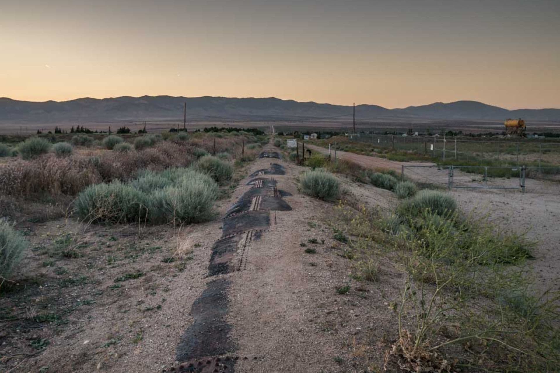
Aqueduct Night Hike
Interest: ⭐⭐⭐⭐⭐
Difficulty: ⚠️⚠️⚠️
Inconvenience: 😫😫😫😫
Stupid: 💩💩💩
Summary
The Aqueduct is an infamous 40.9 mi / 65.8 km portion of the Pacific Crest Trail north of Highway 138 (northbound mile 517.6 / southbound mile 2137.6). This section ends at Tehachapi Willow Springs Road (northbound mile 558.5 / southbound mile 2096.7).
You’re only actually following the aqueduct for the southernmost part of this section, but this entire stretch is largely referred to as the aqueduct. It’s the longest, straightest, flattest part of the entire PCT. In addition, there are few opportunities for shade, making it a challenging prospect in the Southern California heat.
This is typically a more common side quest among northbound thru-hikers since southbound hikers typically don’t have to worry as much about the heat by the time they reach Southern California. That said, either group can attempt this side quest.
Interest
Night hiking is a divisive topic among PCT hikers. Some love it; some hate it. If you’re night-hike curious, the aqueduct may be a good opportunity early in the trail (if you’re northbound) to give it a shot.
If you happen to hit the aqueduct during clear weather and a full moon, I would say absolutely give it a shot. Night hiking with no moon and/or in the rain isn’t quite as exciting. However, night hiking can be fun – and sometimes scary – and I would suggest giving it a shot if you’ve never done it before.
Difficulty
Night hiking the aqueduct removes one of the most challenging parts of this section, the heat.
The actual hiking through this section is quite easy – and flat. There is some elevation gain in the latter half of this section approaching Tehachapi Willow Springs Road, but it’s nothing crazy. If you decide to hike this entire section in one night, it could be quite challenging. Most hikers will attempt just the first portion of their night hike, ending somewhere around Tylerhourse Canyon (northbound mile 541.5 / southbound mile 2113.7).
Aqueduct night hike difficulty factor? Three.
Inconvenience
The most inconvenient thing about night hiking the aqueduct is the interruption to your sleep schedule. If you decide to hike the entire 40.9 mi / 65.8 km section in an epic push, I expect you’ll be ready for sleep when you come out the other side – in the daylight.
Alternatively, if you choose to night hike just the southernmost section, you can still get to bed at a decent hour; you’ll probably just lose a few hours of sleep. Be sure to (try to) set up your tent somewhere you’ll be shaded in the morning if you want a few extra hours of sleep following your night hike.
Stupid
It’s less not stupid than it is stupid so the aqueduct night hike side quest gets a stupid score of three.
Some hikers will tell you that night hiking is stupid no matter the circumstances. I say don’t knock it until you’ve tried it.
Trying to do this entire section in one night may end up being a stupid decision if your legs aren’t ready for that big of a push or you wreck your sleep schedule.

Wrap Up
It’s easy to get excited when planning a Pacific Crest Trail hike and imagine you’re going to do ALL THE THINGS. However, the reality is often different from the idealistic plans you make beforehand.
Oftentimes, you’ll be exhausted from hiking, and the thought of venturing off the PCT or adding any complications to your thru-hike will seem like madness. That said, other times you may be inspired to put in some extra effort and get some bonus XP.
Have a Pacific Crest Trail Southern California side quest that you believe is worthy of making this list? Know of a desert side quest that more PCT hikers should be taking advantage of?
Leave a comment below or get in touch!
Affiliate Disclosure: This page may contain affiliate links, which means I may receive small commissions for purchases made via these links at no additional cost to you. This helps pay the bills and keep the site up and running. Thank you for your support!


im thinking of doing “Half dome” if i can get a permit
That’s on the list for the Sierra Side Quests!
https://www.halfwayanywhere.com/trails/pacific-crest-trail/pct-side-quests-sierra/
Man, reading this makes me kinda sad I missed the summit of San Jacinto! But I had tweaked my ankle earlier in the day and it was 2019 so the snow was still deep, which upped the stupid factor for me that particular day. Might have to make it a fun bonus adventure next time I’m in SoCal.
If you want to do it the exciting way, look at doing Cactus to Clouds: https://www.halfwayanywhere.com/trails/cactus-to-clouds/c2c-hiking-guide/
The McDonalds was closed when we went through —in 2023 it had reoccurring problems with water.
We flipped up to Walker Pass and did the Aquaduct SOBO by getting up really early and hiking into Hikertown and we saw others who left Hikertown and started north around 6:00 or so.
it was great and easier than hiking in the sun.
You didn’t miss much at the McDonald’s – the nearby gas stations are excellent substitutes.