
How to Connect the SoSHR and the SHR
The Sierra High Route and the Southern Sierra High Route are two incredible routes through California’s Sierra Nevada that are each remarkable on their own. However, it is possible to connect these two routes into a single and most epic journey through the Sierra. Here’s how to do it.
The Short Version
This post goes into a lot of detail about connecting the two routes.
If you want the one-sentence summary, here it is: connect the Southern Sierra High Route and the Sierra High Route by planning to hike the entirety of the SHR and then taking the Bubb’s Creek Trail between Road’s End (the southern terminus of the SHR) and where the SoSHR intersects the Bubb’s Creek Trail south of Glen Pass; the only parts of the SoSHR you’ll miss by doing this are on-trail miles following the PCT/JMT and Bishop Pass Trail.
SoSHR and SHR Overview
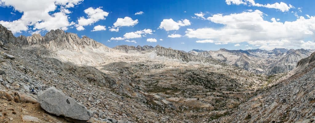
The Sierra High Route covers approximately 195 miles / 314 km with its southern terminus at Road’s End in Kings Canyon National Park (via the Copper Creek trailhead) and its northern terminus at Mono Village at Twin Lakes (just outside of Bridgeport). This route is typically hiked south to north (as this is how it’s described in Steve Roper’s book, Sierra High Route: Traversing Timberline Country), but there’s no reason you couldn’t reverse the route (the book offers notes on doing just this for each section).
The Southern Sierra High Route covers approximately 100 mi / 160 km with its southern terminus at Horseshoe Meadow (west of Lone Pine) via the Cottonwood Lakes/New Army Pass trailhead and its northern terminus located at South Lake via the Bishop Pass trail. This route is typically hiked north to south, but again, there’s no reason that you can’t reverse the route (I hiked it south to north).
Where They Overlap
Luckily, connecting these two routes is relatively simple since they not only overlap a bit, but they also operate (mostly) at different latitudes (precisely why the Southern Sierra High Route is named as such – it’s essentially meant to be an extension of the Sierra High Route).
The only caveat here is that you will forgo hiking the SoSHR section between the junction of the Pacific Crest Trail (PCT)/John Muir Trail (JMT) and the Bubb’s Creek Trail and the junction of the PCT/JMT and the SHR (just south of Mather Pass). However, chances are that if you’re reading this and are interested in hiking both the SHR and the SoSHR, then you’re not going to be upset about missing ~28 mi / 45 km of on-trail hiking over Glen Pass and Pinchot Pass.


The overlapping section of the Southern Sierra High Route and the Sierra High Route runs from immediately south of Mather Pass and continues approximately 13 mi / 21 km north to where the Bishop Pass trail intersects the two routes in Dusy Basin.
The two routes both go over Mather Pass, Cirque Pass, Potluck Pass, and Knapsack Pass. North of Knapsack Pass, the Sierra High Route follows the Bishop Pass trail west down to the PCT/JMT before continuing north over Muir Pass; the Southern Sierra High Route follows the Bishop Pass trail east over Bishop Pass and to the route’s northern terminus at South Lake. South of Mather Pass, the SHR splits off west from the PCT/JMT and crosses Frozen Lake Pass; the SoSHR follows the PCT/JMT south over Pinchot Pass.
The Southern Terminus
If you’re connecting the Southern Sierra High Route and the Sierra High Route, the southern terminus of your hike will be the Cottonwood Lakes trailhead at Horseshoe Meadow (map). This is not to be confused with the Cottonwood Pass trailhead (also located at Horseshoe Meadow).
The SoSHR goes over New Army Pass via the Cottonwood Lakes trail. You can connect the route over Cottonwood Pass to the SoSHR north of New Army Pass, but the route over New Army is far more scenic (Cottonwood Pass is pretty meh).


Horseshoe Meadow is located west of Lone Pine on Highway 395. It’s a 23-mi / 37 km drive up over 6,000 ft / 1,800 m of elevation from Lone Pine to Horseshoe Meadow. There is no charge to leave a car at Horseshoe Meadow.
At the trailhead, you will find plenty of parking, pit toilets, trash cans, bear boxes, and potable water (typically turned off sometime in October).
There are three campgrounds at Horseshoe Meadow:
- Cottonwood Pass Walk-in Campground | $6 per night, one-night limit – no reservations, register at the campground – website
- Cottonwood Lakes Walk-in Campground | $6 per night, one-night limit – no reservations, register at the campground – website
- Horseshoe Meadow Equestrian Camp | $12 per night, no reservations, register at the campground – website
The road up to Horseshoe Meadow is generally closed from November to May because of snow.
The Northern Terminus
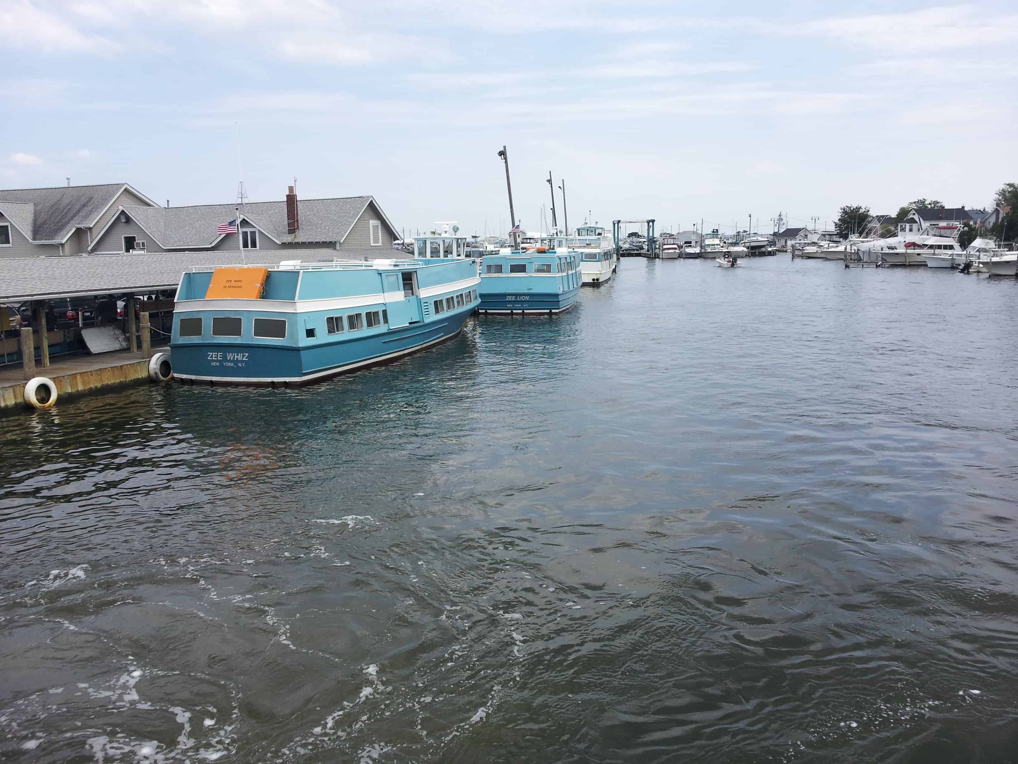
If you’re connecting the Southern Sierra High Route and the Sierra High Route, the northern terminus of your hike will be the Horse Creek Falls trailhead at Annett’s Mono Village (map) located at Twin Lakes just outside of Bridgeport on Highway 395.
It’s about 14 mi / 22.5 km from Bridgeport to Mono Village via Twin Lakes Road. Mono Village is a haven for old, overweight, white Republicans with expensive RVs and nothing else to do with their children’s inheritance. And I’m sure other people want to get outdoors as well. Mono Village has a small convenience store, a campground, flushing toilets, cabins for rent, coin-operated showers, laundry, and (apparently) Wi-Fi.

The cost to park a car at Mono Village is $15 for up to seven days (and I would assume an additional $15 per seven-day period following the first). Camping at Mono Village costs $28 per day (plus tax) for 2 people with a charge of $3 per day per additional person. They accept cash and credit cards.
The total driving distance between Horseshoe Meadow and Mono Village is 183 mi / 295 km.
Connecting The Routes
Connecting the Sierra High Route to the Southern Sierra High Route is simple.
If you’re heading northbound, split off from the SoSHR/Pacific Crest Trail/John Muir Trail when you reach Bubb’s Creek Trail south of Glen Pass. You follow Bubb’s Creek Trail 12.3 mi / 19.8 km west to Road’s End – the southern terminus of the SHR. Once you reach Road’s End, simply hike the SHR northbound as your time on the SoSHR has come to a close.
If you’re heading southbound, split off from the PCT/JMT after crossing Mather Pass and follow the SHR over Frozen Lake Pass (instead of following the SoSHR south over Pinchot Pass). Then, once you reach the southern terminus of the SHR at Road’s End, follow the Bubb’s Creek Trail east until you intersect the SoSHR/PCT/JMT. When you reach this junction, simply continue south on the SoSHR.

Alternatively, you can follow the SoSHR/PCT/JMT between Mather Pass and the Bubb’s Creek junction, but then you’ll be missing the southernmost section of the SHR – a much more scenic and exciting section of the Sierra than following the SoSHR along the PCT/JMT.
Road’s End is indicated on the map below (the Bubb’s Creek Trail is accessible via the Rae Lakes Loop Trailhead).
What You’ll Miss
It’s possible you’ll miss the northernmost section of the Southern Sierra High Route from Dusy Basin over Bishop Pass to South Lake (the northern terminus of the SoSHR) if you plan on connecting the two routes.
This section of the SoSHR is on-trail and is more a means of getting into/out of the mountains than it is a not-to-be-missed area. I promise that if you’re hiking the rest of the Sierra High Route and the SoSHR, you will not be disappointed for having missed the section of trail between Dusy Basin and South Lake.
However, if you want to make this section part of your trip, you could resupply via Bishop Pass/South Lake. This way, you will not be missing this section of the SoSHR. You can leave a car parked at South Lake (map), hitchhike into Bishop, or take the Bishop Creek Shuttle for $5 (stops at South Lake twice daily at 8:45 a.m. and 4:45 p.m.) (the Bishop Creek Shuttle has been discontinued).


By connecting the two routes via the Bubb’s Creek Trail, you will also be missing the section of the SoSHR from just south of Mather Pass to the intersection of the PCT/JMT and the Bubb’s Creek Trail. However, this ~28 mi / 45 km section consists entirely of on-trail hiking over Glen Pass and Pinchot Pass. Within this section, there’s an alternate you can take over Mount Baxter, which could be considered the one worthwhile thing you will miss on the SoSHR.
That said, the section of the SHR you will be hiking instead (which is nearly entirely off-trail) more than makes up for a trip over Mount Baxter and lots of on-trail PCT/JMT hiking.
Resources
- USFS: Cottonwood Pass Walk-in Campground
- USFS: Horseshoe Meadow Equestrian Camp
- USFS: Horseshoe Meadow Campground Guide
- Book: Sierra High Route: Traversing Timberline Country
- Adventure Alan: Southern Sierra High Route
- Annet’s Mono Village
Bishop Creek Shuttle (Eastern Sierra Transit Authority)


Just FYI, they’ve discontinued the Bishop Creek Shuttle. Very annoying.
Thanks for pointing that out! I’ve updated the article.
How much of the SHR and SoSHR overlaps the PCT/JMT? When I did the PCT I noticed that some signage I came across implied that I was on the SHR as I exited and entered again the PCT via the trail to/from Roads End
I don’t know that there’s any signage you would encounter indicating the SoSHR or SHR, but the SoSHR overlaps the PCT/JMT from north of Forester Pass to the north end of Palisade Lakes.
The SHR overlaps in a few spots including from just south of Mather Pass to the north end of Palisade Lakes, the intersection of the Bishop Pass Trail/PCT JMT to the north end of Evolution Lake, just south of Lake Virginia to the junction for Duck Lake, and very briefly near Tuolumne Meadows.